This year Great Rivers Greenway is celebrating a quarter-century of building greenways in the St. Louis region. The organization’s funding, born out of a public vote in November 2000, started GRG down the path to creating the 140 miles of trails, thousands of acres of public space, and 3 million yearly trail visitors they boast today.
While the St. Louis region’s trail-building org became a reality in 2000, its origins start much earlier. Below is a timeline of that history, and following is a conversation with GRG’s Emma Klues, looking back(and forward) to this legacy.
Trailnet: GRG Prehistory
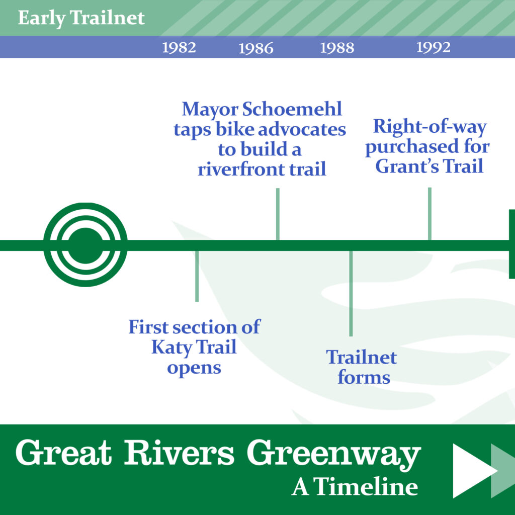
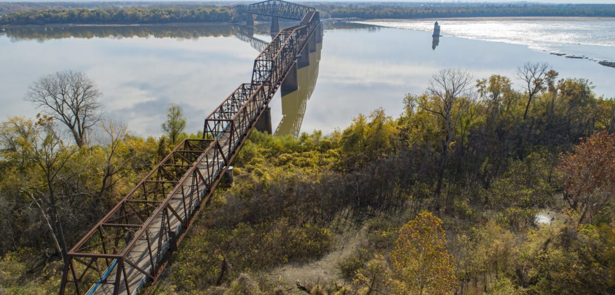
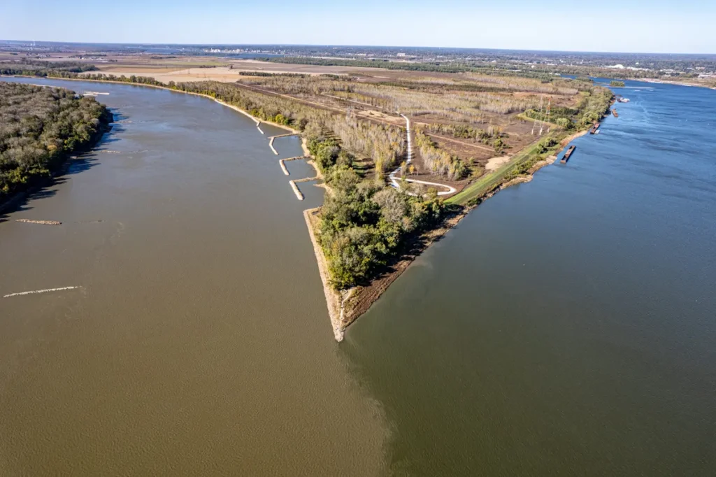
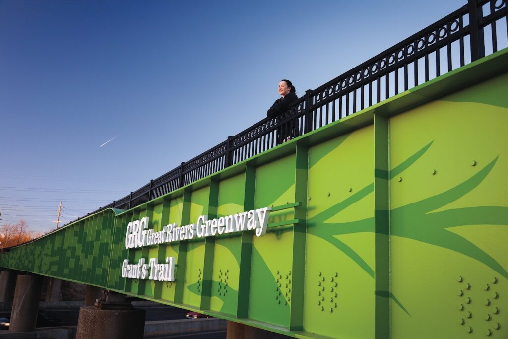
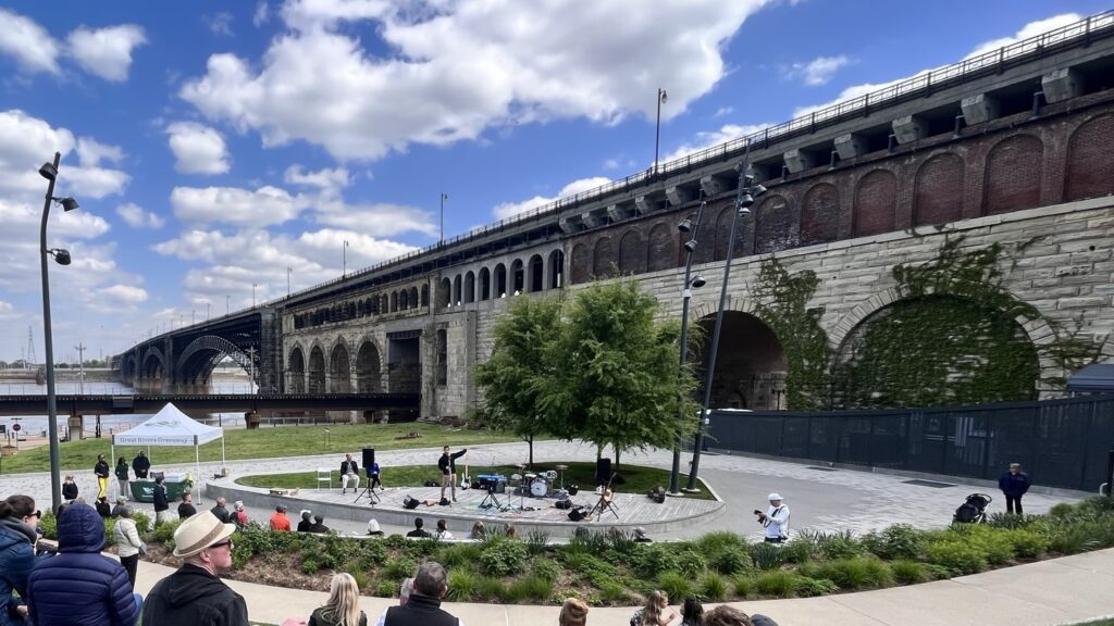
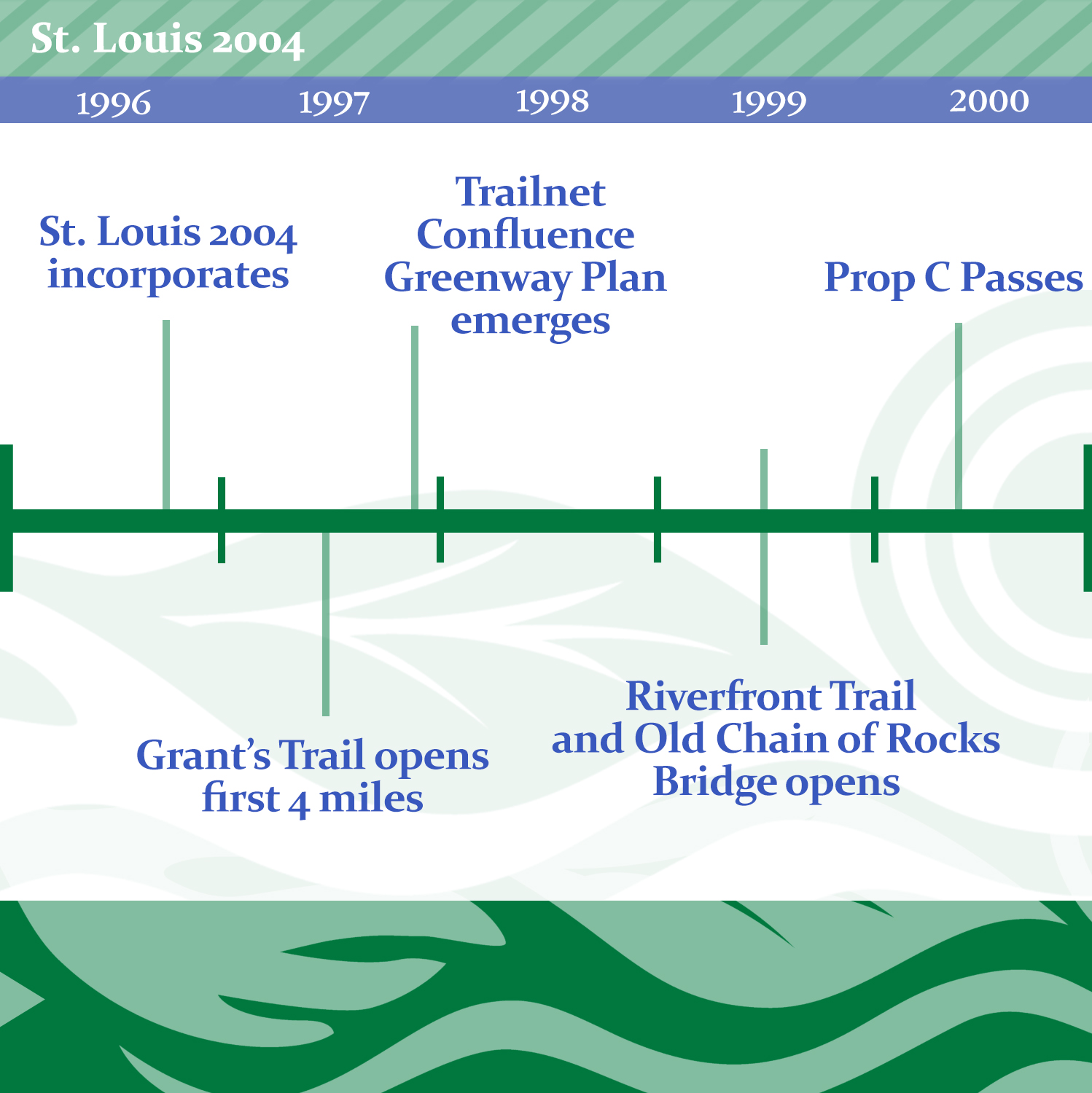
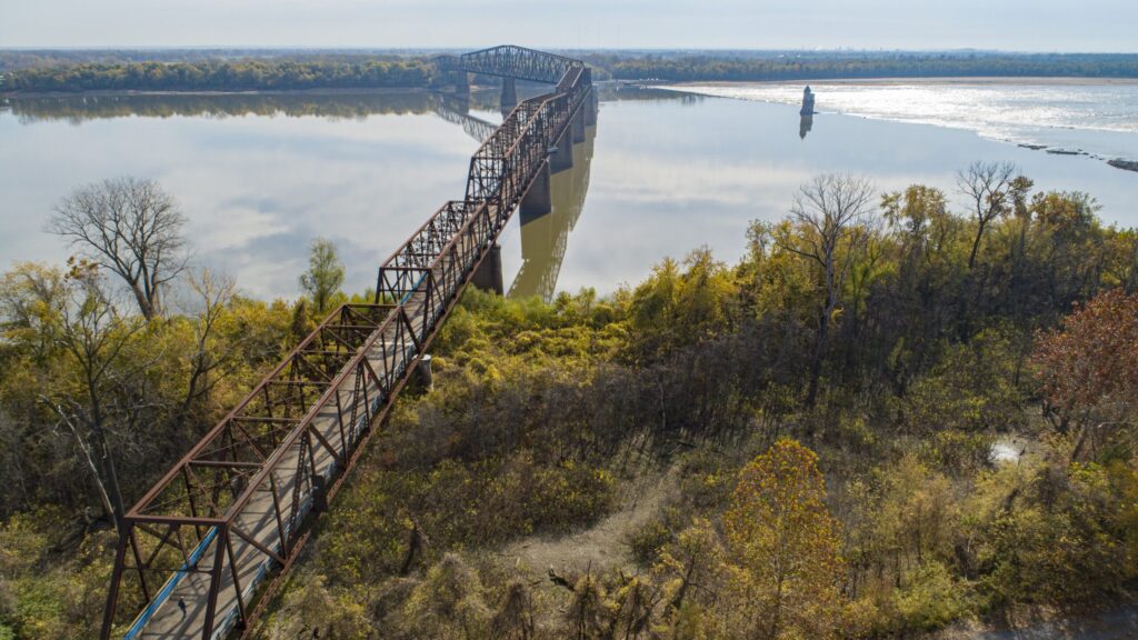
The region’s precursor to GRG is Trailnet. Trailnet, established in 1988, grew out of a mandate by then mayor Vincent Schoemehl to create what is now the Riverfront Trail (now part of GRG’s Mississippi Greenway). Since GRG’s inception, Trailnet’s focus has shifted to planning and advocating for on-street bike lanes, but in the 90s they were the region’s primary trail-building org. By 1992 they had purchased 6 miles of the former Union Pacific right of way near Grant’s Farm. After winning a lawsuit against local nimbys, the trail began construction 1994. By 1997 they had opened the first 4 miles of Grant’s Trail (now part of GRG’s Gravois Greenway). By 1999 they had completed 11 paved miles of the Riverfront Trail from Laclede’s Landing to a renovated Old Chain of Rocks Bridge. The trail and the bridge opened to the public that same year.
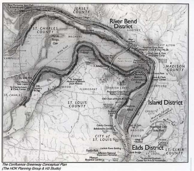
But Trailnet hadn’t planned to stop there. They were in the planning stages of something called the Confluence Greenway, a plan that would put similar trails along Missouri and Mississippi River corridors on both sides of the river, and eventually connect to the growing Katy Trail, which had made it as far east as St. Charles in 1996. By then, these trails had gained the attention of civic leaders in STL hoping to keep the trail wins coming.
St. Louis 2004 and Prop C
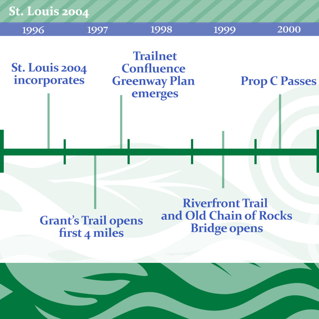
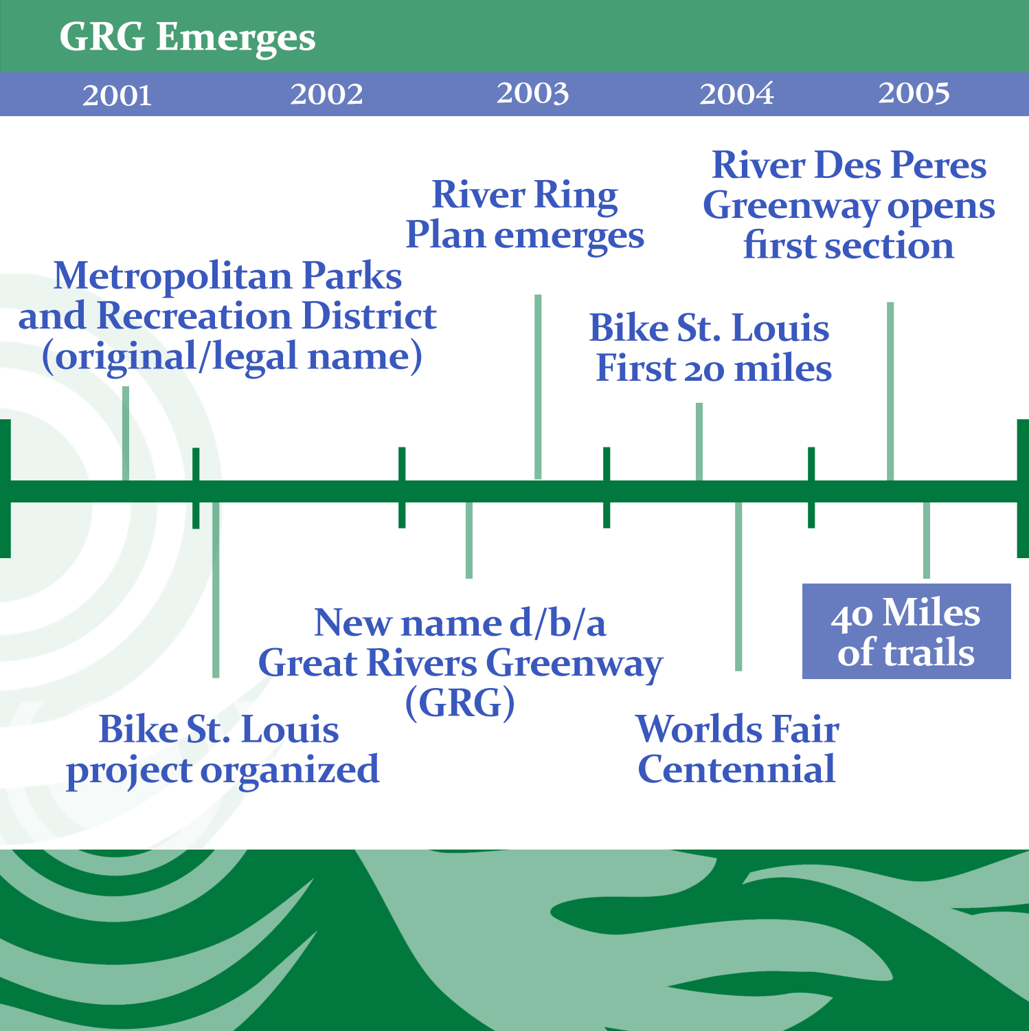
St. Louis 2004 was a public-private initiative begun in 1996 –in-part out of the St. Louis booster org Civic Progress– with the goal of moving the needle on civic issues in STL by the centennial of the 1904 Worlds Fair. Starting with broad conversations on the needs of the region, they landed on several initiatives, including the trail-forward Regional Parks Initiative. Taking Trailnet’s Confluence Greenway as a major goal, the Regional Parks Initiative was eventually spun into a ballot proposition “The Clean Water, Safe Parks, and Community Trail Initiative”- 1/10 of a cent sales tax levied across St. Louis City, St Louis County and St. Charles County. Voters passed the proposition in November of 2000 and a new org was born…”The Metropolitan Parks and Recreation District”
The MPRD adopted the Confluence Greenway plan, and immediately got to work purchasing land. They purchased some 614 acres near the confluence (for what would eventually become a State Park and Katy Trail’s eastern terminus.) MPRD expanded the purview of the Confluence Plan to numerous watersheds in the region including the Meramec and River Des Peres. Additionally the org spun off Bike St. Louis, a collaboration with St. Louis city and other municipalities to plan, fund, and create on-street commuter bike lanes in the region.
GRG Emerges: The River Ring
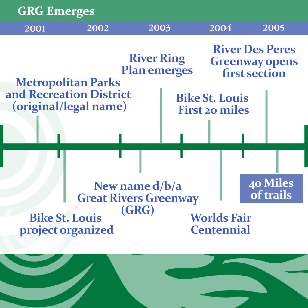
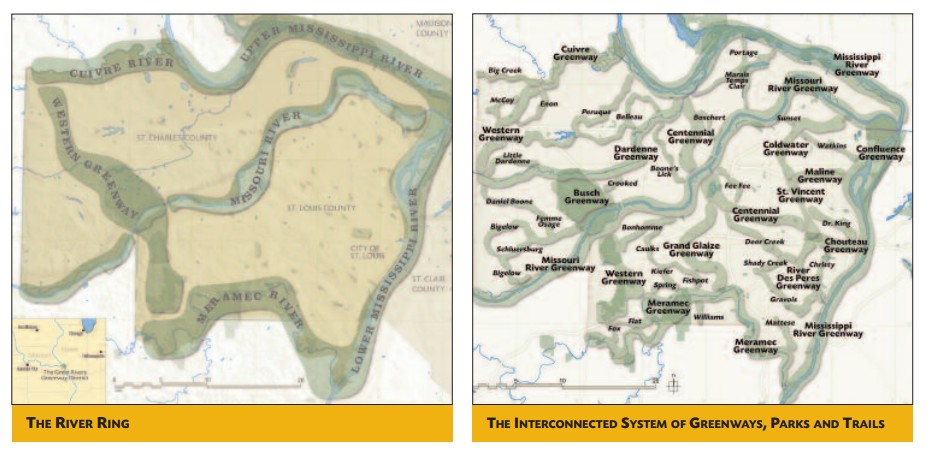
By 2004 the MPRD shed its public facing moniker for a catchier one, and started doing business as Great Rivers Greenway District(GRG). Alongside their new name they upgraded the Confluence Plan to the massively ambitious “River Ring” plan – a system of greenways that connected most or all of the major watersheds across all three counties –encircling the St. Louis area.
The River Ring would be the guidepost for GRG for the next decades. New greenway plans were added for the St. Vincent Greenway – a greenway connecting Forest Park to UMSL, Chouteau Greenway – a greenway in Downtown St. Louis connecting to Forest Park and incorporating a rebuilt Chouteau’s Pond. Other plans called for connecting the in-progress River Des Peres Greenway to Grants Trail, and greenways throughout St. Louis County and St. Charles County too numerous to name. By 2004 Bike St. Louis already boasted 20 miles of bike lanes. GRG was still in its infancy, but its harbinger – St. Louis 2004’s Regional Parks Initiative –indeed had a lot to show for its banner year.
Boom Years
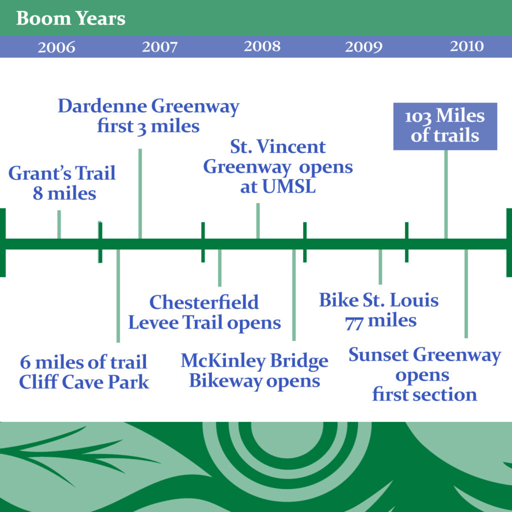
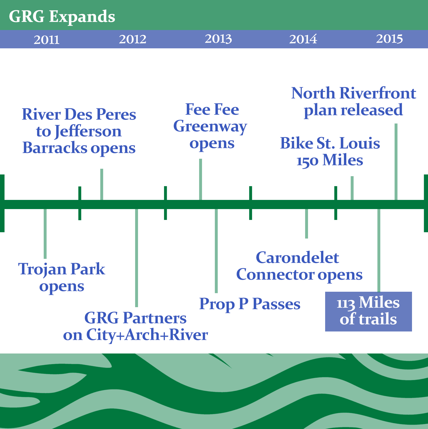
The next five years saw steady gains throughout the region. Greenway miles ballooned from 40 in 2005 to 103 in 2010. In the time, Grant’s Trail had expanded to 8 miles and connected to Kirkwood. River Des Peres Greenway, the first fully GRG created trail, opened from Gravois to Morganford. In St. Louis County and St. Charles Co., new sections of trail opened in the Dardenne, St. Vincent, Centennial, Bochert, Busch, Deer Creek, Missouri River, and Sunset Greenways.
That progress continued into the next five, with new trails opening in the Fee Fee, Mississippi, and Meramec Greenways, among them the Carondelet Connector – connecting the River Des Peres Greenway to Carondelet Park. Together they bring the total trail mileage by 2015 to 113 miles.
GRG Expands: CityArchRiver
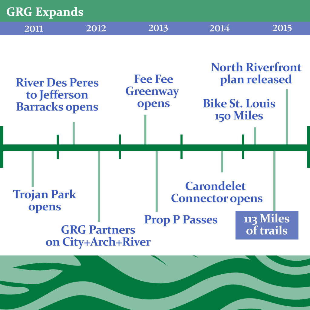
If the 2010 to 2015 gains seem meager compared the previous five years, it may simply follow the rule of diminishing returns–with the easy wins behind them, GRG was moving into a period of more complicated acquisitions and planning. But these years also saw the beginning of an expansion and evolution for the organization. In 2012, GRG partnered with the CityArchRiver project, a massive project to remake the Arch grounds, renovate the Old Courthouse, put a cap over the highway, and redo Leonor K Sullivan Blvd –all including miles of trails. Toward this end, a new funding proposition emerged in 2013, this one perhaps more contentious –Prop P: The Safe and Accessible Arch and Public Parks Initiative: a 3/16 sales tax levied to fund much of the renovation of the Arch grounds and to secure more spending power for GRG across the board. The proposition passed in November of 2013.
With a renewed focus on the downtown riverfront, GRG released the North Riverfront Open Space and Redevelopment Plan in 2015 –a plan that called for parks along the riverfront, office and residential development to its interior, and included an alternative plan that incorporated a massive football stadium at the district’s northern end – though all attempts to keep the Rams in STL would, of course, eventually prove fruitless.
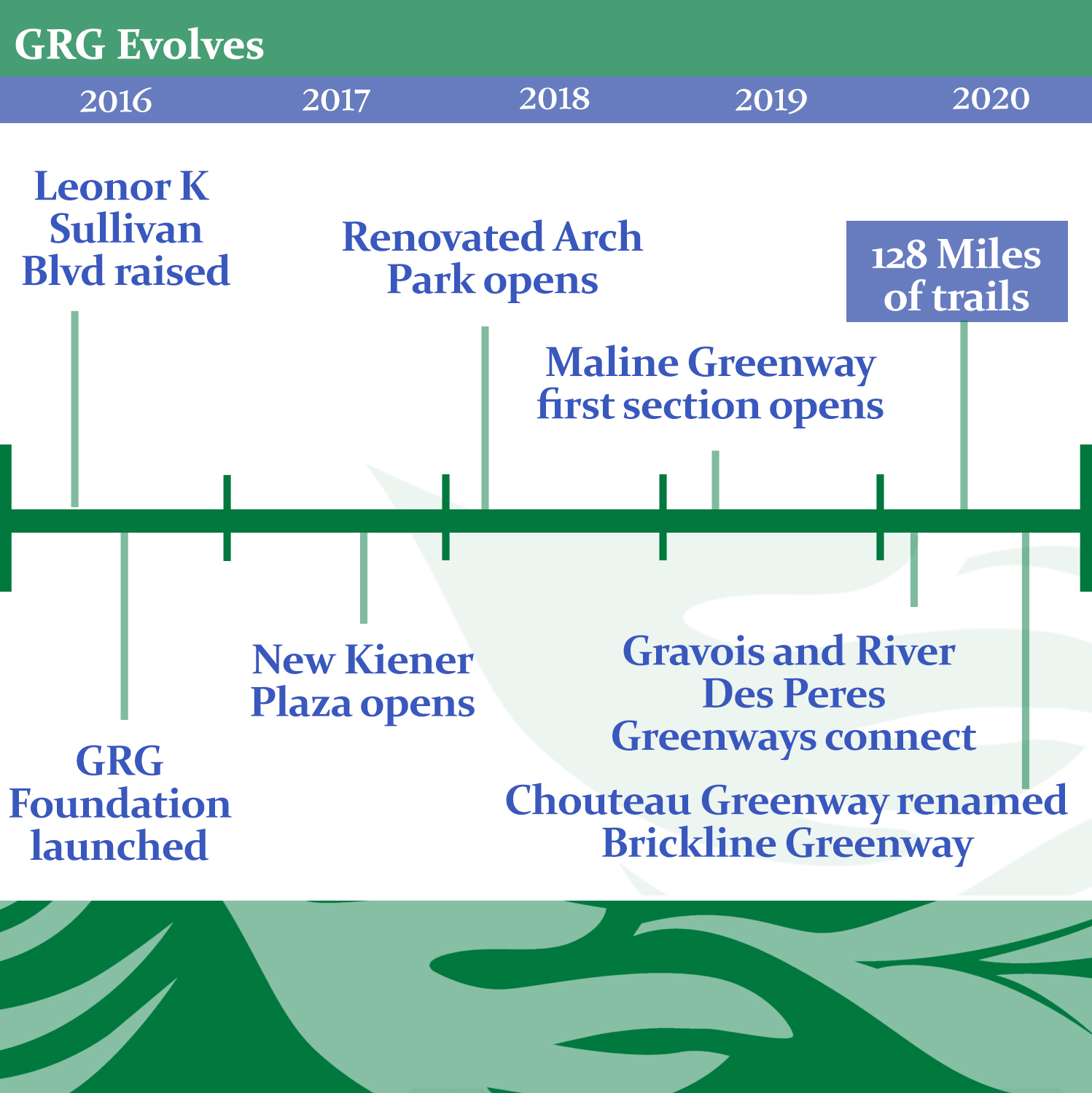
Indeed as GRG expands, their focus also begins to evolve in a few key ways starting in 2016. That year, they announce the Great Rivers Greenway Foundation – to bring additional private dollars into their funding structure. The foundational River Ring concept while still reflecting much of their planning effort, is quietly retired in many marketing and planning documents. With new avenues of funding and an updated conceptual framework(updates come to their strategic plan on a five year cycle), GRG enters a new era.
GRG Evolves: From Chouteau Greenway to Brickline Greenway
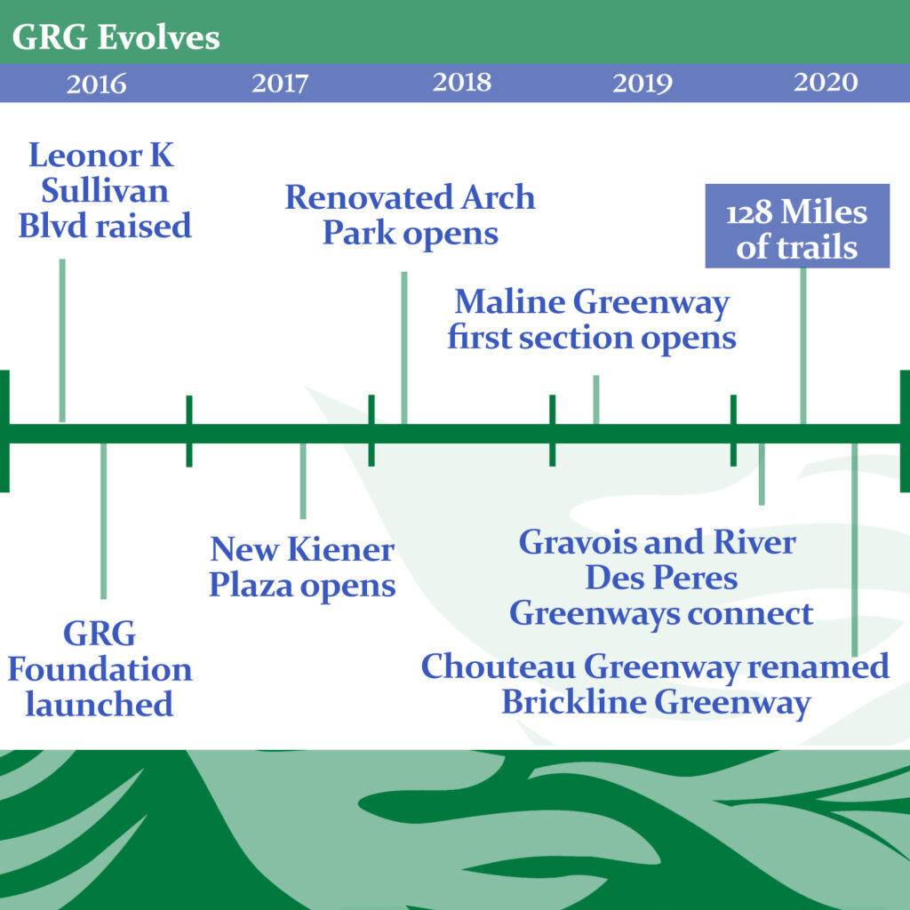
Creating park space in the North Riverfront, and pursuing the reintroduction of Chouteau’s Pond were some of the earliest mandates from the fledgling Regional Parks Initiative. Indeed McCormack Baron’s Chouteau Lake and Greenway Plan (CLG) held space in the org’s planning documents since its inception and land to build it had been purchased by GRG in 2004. However, that had shifted by 2016.
According to Richard Baron of McCormack Baron, then mayor Francis Slay said no to the city’s supporting funding efforts for the Chouteau Lake and Greenway Plan in favor of focusing fully on CityArchRiver. The other shoe dropped for the CLG in 2016 when GRG announced a competition to rethink the Chouteau Greenway.
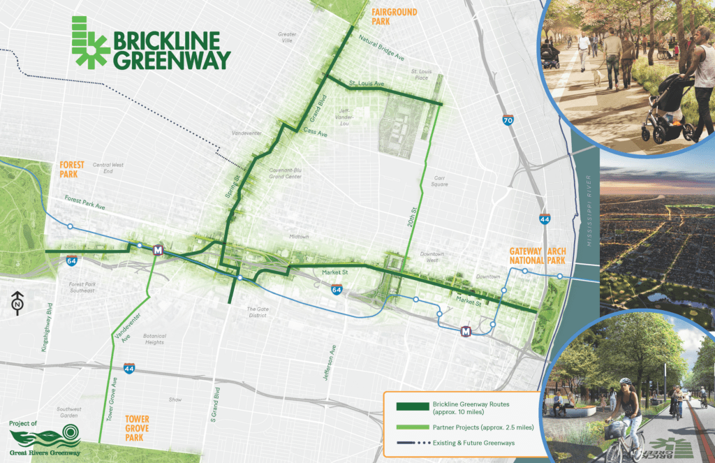
In 2018, GRG chose a winner –Stoss Landscape Urbanism’s “The Loop + The Stitch” plan from the Chouteau Greenway competitors. A cross-shaped plan connecting North to South and East to West that would see the Chouteau greenway connect Forest Park to the Arch and Tower Grove Park to Fairground Park. At this point the Chouteau Greenway didn’t look much like the CLG, and another competition was held to rename it, the winner: Brickline Greenway.
While the Brickline Greenway is a very different beast from the CLG, planning has not continued for a separate Chouteau Greenway – an outcome I have argued for elsewhere – even suggesting a plan that would connect the CLG plans through population dense South St. Louis all the way to Carondelet Park.
Brickline Emerging
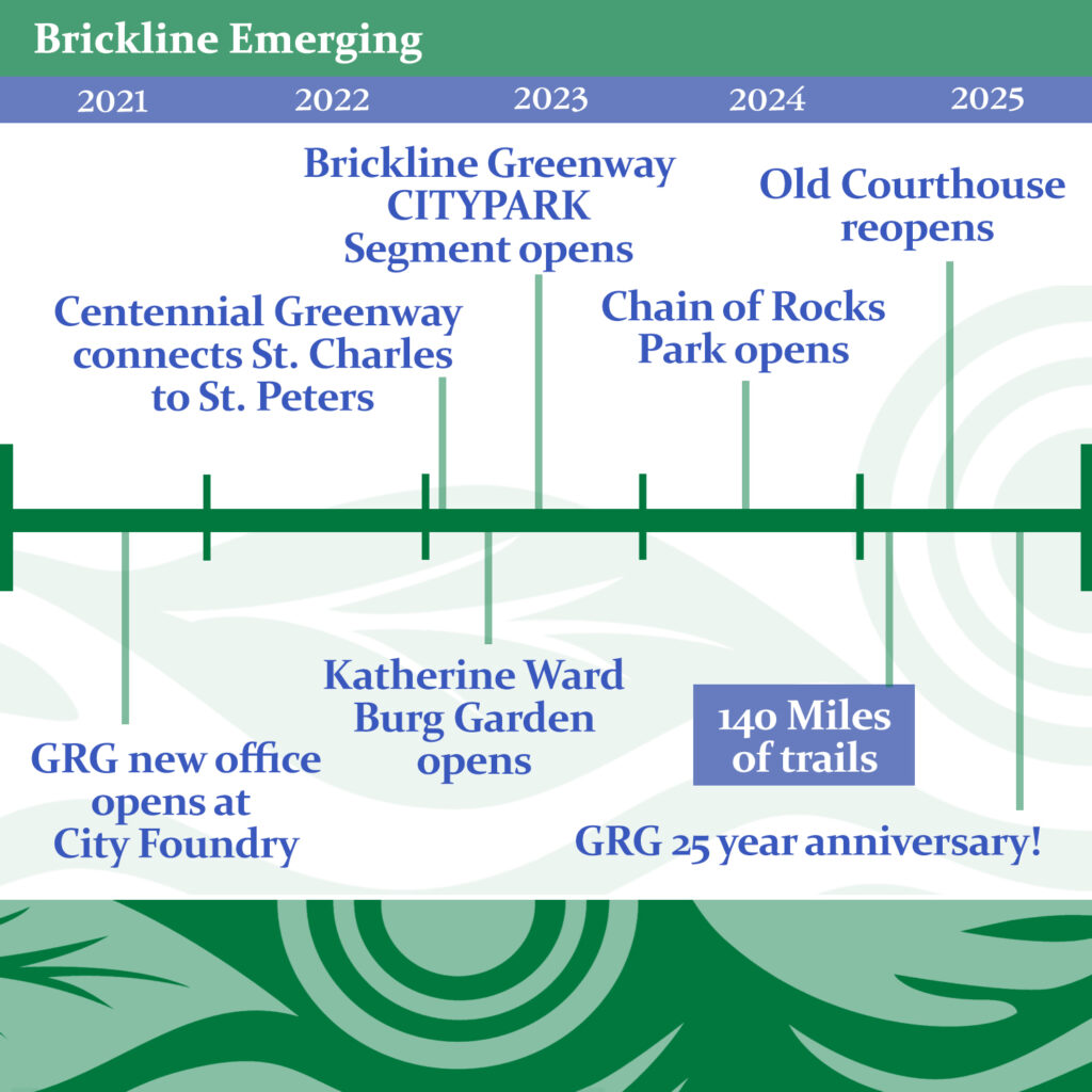
The Brickline really gets going in these past five years. A small section opened next to the new soccer stadium Citypark in 2023. A large section along Market between Compton and 22nd is currently in construction, as is the Tower Grove Connector –a STL City project connecting the Brickline to Tower Grove Park. A massive section on North Grand connecting the network to Fairground park has begun construction and is due to be complete in 2027. A bridge has been funded to take the trail through the HWY 64/40 stack at City Foundry.
While the Brickline Greenway has become GRG’s flagship in STL city over these past 10 years, GRG has of course continued building out the network elsewhere. By 2020 total trail mileage reached 128 miles. Trojan park opened along the St. Vincent Greenway in 2016. In 2017 the new Keiner Plaza(part of the CityArchRiver project) opened, the newly completed Arch grounds opened in 2018. That same year the Mississippi Greenway section opened in Cliff Cave Park. A bridge over the River Des Peres is the last piece of the puzzle in connecting the River Des Peres Greenway to the Gravois Greenway creating one contiguous 22 miles of trail in 2020. While progress moves slowly on the North Riverfront, the first little piece north of the Arch grounds, Katherine Ward Burg Garden, opened in 2023. At the crux of the riverfront trail and the Old Chain of Rocks bridge, the new Chain of Rocks Park opened in 2024
Great Rivers, Great Greenways

What started with a mayor’s dream to build a trail along the riverfront, has some 40 years later become a vast and growing network of trails and public spaces that would be the envy of any metro. It’s no exaggeration for me to say that since its inception 25 years ago, Great Rivers Greenway, taken together in its many partnerships, plans, initiatives, trails, parks, and conservation efforts, is STLs single greatest achievement in that time, and a living testament to what we can do when we come together as a region. What could be better than inspiring public greenspaces and a network of safe trails to connect them in the heart of a metro area? Here’s to another 25.
(Side note: While GRG has a truly regional focus – as a city dweller, I have focused perhaps overmuch on STL City’s trails to the neglect of St. Louis County and St. Charles county trails. Such is the massive scope of this work, that I must choose my battles.)
Slide through the images below to view the entire timeline–


A Conversation with GRG’s Emma Klues
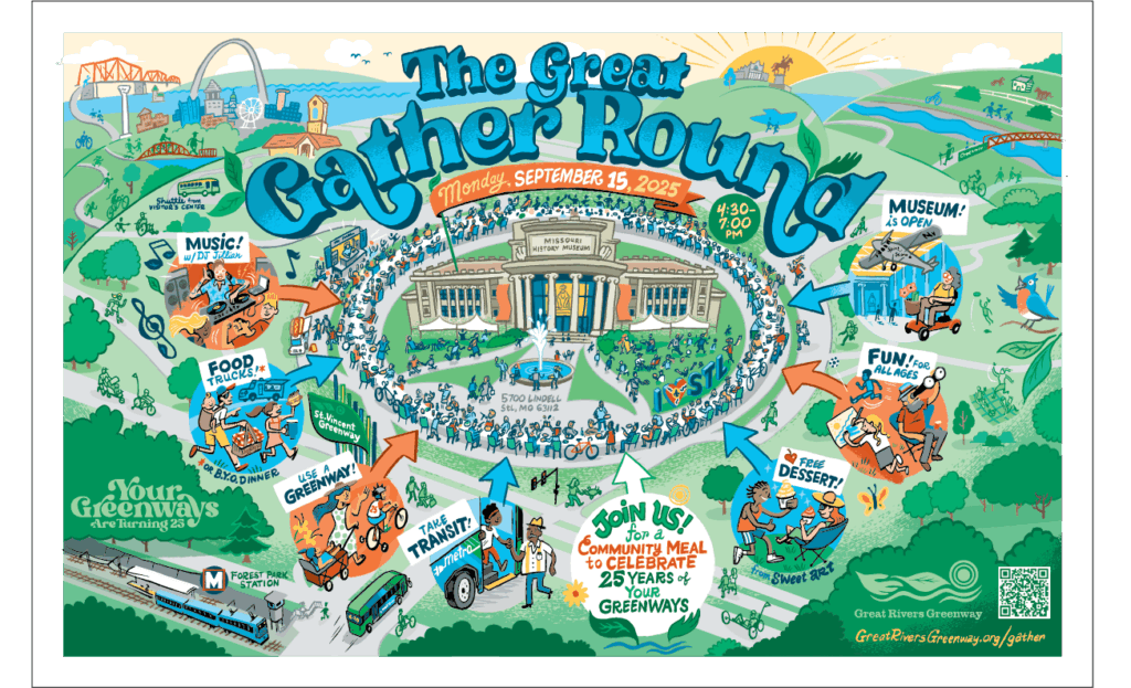
GRG is celebrating its first 25 years with events happening through the rest of the year, beginning next Monday September 15th from 430 to 7pm with the Great Gather Round, a community picnic featuring music, food trucks, and a 1500 foot gathering table– all at the Missouri History Museum. I took the opportunity to catch up with Emma Klues, the event’s planner and GRG’s Vice President of Communications and Outreach to ask a few questions about GRGs storied history:
MM: My own first interaction with GRG’s greenways would have been riding Grant’s Trail (now Gravois Greenway) some 15 years ago. What were some of GRG’s earliest strides? How did those early strides affect what came next?
EK: Some of the early strides, in addition to the groundwork laid by Trailnet for Gravois Greenway: Grant’s Trail and Mississippi Greenway: Riverfront Trail, were partnering on projects in the Meramec Greenway (which had many plans pre-dating us, which helped to solidify the commitment from multiple stakeholders) and River des Peres Greenway. All of these helped people to see (literally) that greenways had many different benefits, recreational, transportation, health, environmental and community connections. Having some proof of concept was crucial in the communities we engaged next being willing to discuss future projects. Additionally, the success of the KATY Trail helped pave the way (pun intended) for proof points for Missourians as well. While we’ve always had to work through challenges and opportunities with community members, we’re fortunate and thrilled to be (in my 11 years) largely be in a place where people want them faster than we can build them.
MM: Ok. I’m a bit confused I think with the trail vs greenway naming conventions. Like Grant’s Trail vs Gravois Greenway. Does the new name indicate that it is maintained by GRG?
EK: Greenways are trails that are part of the network, we use the terms interchangeably but prefer greenway for names and trail for a defining characteristic – the path itself. Ideally, all of them are called greenways so people know what to expect (a paved, accessible pathway/trail, conservation projects along the way, amenities, signage, etc) and can associate them with the overall network, like other parts of the same greenway. IE Mississippi Greenway in Cliff Cave Park will eventually connect to Mississippi Greenway in Jefferson Barracks and Mississippi Greenway by the Arch –all along the Mississippi River. Greenway names are often –but not always – watershed names.
None of the greenways are primarily maintained by GRG, they’re built by us, with partners and community input, and then turned over to the municipality or operating partner to operate and maintain. We have no powers of law enforcement or jurisdiction to do repairs. That being said, we often step in when partners need us, to ensure there’s an excellent experience across the varied and variably-resourced 3-county, 120-town region we serve.
MM: Speaking of rivers, one of GRGs early concepts was the “river ring.” Can you explain the concept, and speak to the progress that has been made?
EK: Yes! The big idea from our original 2004 plan was to connect a large “ring” around the rivers with greenways that follow waterways, including the creeks and tributaries around them for an interconnected network. Rivers not only are such a source of life and resource, but a huge driver of commerce as well, and the idea was to get people back in touch with the rivers that are a huge part of our history and why St. Louis has always had opportunity to thrive. The main three outcomes of that first plan were economic development, social capital and environmental stewardship.
Now in 2025, we continue to maintain the goal for people being connected to natural assets, including waterways, but we also have evolved the thinking to shape the network of greenways in two key ways: One–Flooding continues to be a major challenge in our region. Greenways that were originally built along these major rivers are not always able to withstand the incredibly powerful and more frequent flooding events. While we continue to drive toward people having access to rivers and views, we are not building as many paved trails alongside the substantial waterways. Two – People want these greenways to connect in their everyday lives. The critical connections to neighborhoods, jobs, transit and destinations have been steadily gaining importance for people’s daily transportation, exercise and connections to community.
MM: Securing a funding source via proposition C in 2000 was the win that brought GRG to life. In your opinion, what have been some of the biggest victories since? Though you’ve only been with GRG for part of this ride, what moments have been the most personally rewarding for you? What future projects are you most excited about?
EK: This is like picking a favorite family member! I think some of our biggest victories range from specific projects to overall progress. One would be –Being a partner in the CityArchRiver project was a gamechanger for us. We are one of the 6 partners in the alliance that helped to get the project built and continue to operate and maintain the site. We learned so much through the international design competition, a major public-private partnership and collaborating with so many entities in a very complicated area with federal, state and local jurisdiction as well as nonprofit foundations. Figuring out how to make sure the investment was a benefit to local contractors, how to work through complex construction at our city and state’s front door, and how to take care of a new space when partners’ capacity and budgets were not increased to care for new spaces.
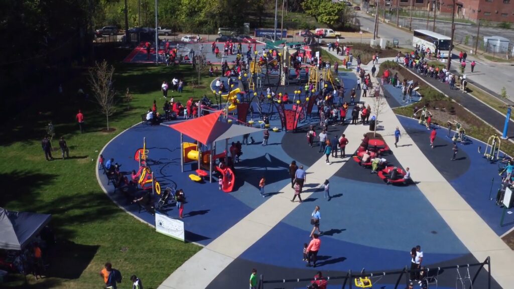
Trojan Park on the St. Vincent Greenway was a huge win – this was part of the Parks Build Communities initiative of the National Recreation and Park Association (NRPA)’s coming to St. Louis for their conference in 2016. The Wellston community had been very clear about wanting more places to gather and being able to deliver a world-class park was incredibly rewarding. Residents got to name it (after the Eskridge High School Trojans, which was no more after consolidation with the Normandy School District), and pick out equipment and features (including adaptive swings, musical instruments, fitness equipment, splash pad, pavilion and grills, and more) for NRPA to request from their vendors and exhibitors to be donated, free of charge. The Jr NBA even donated a full-court basketball court (the first in Wellston) for a community who has sent more than one graduate to the NBA.
Generally, the anecdotal wins for me include seeing unsolicited real estate and apartment listings where people list the greenway proximity as a selling point, hearing from people who’ve grown up next to a greenway and never known life without one, hearing from people about how this was a crucial part of their mental, physical and emotional health during the pandemic, and so many more.
Looking forward, I am a City resident so I am personally excited for the Brickline Greenway to take shape. It’s already come so far and it’s really aligned with the original community goals. I am also looking forward to extending the Centennial Greenway in Olivette and Creve Coeur, eventually taking people all the way to Creve Coeur Park!
MM: In balancing transportation, conservation, and recreation–it sound like you’re saying in the broad arc of these 25 years the organization has shifted some in its goals to privilege transportation utility over the other two concerns.
EK: I don’t think it has shifted to privilege transportation over the other two, but many of the earlier projects happened to have higher recreation and conservation goals than transportation. So now, we are balancing a little bit with some of the current projects. All of those goals (plus health, economy, social connectivity) are still applicable to projects and are always being balanced over time and across the 3 counties, in partnership with community priorities and opportunities.
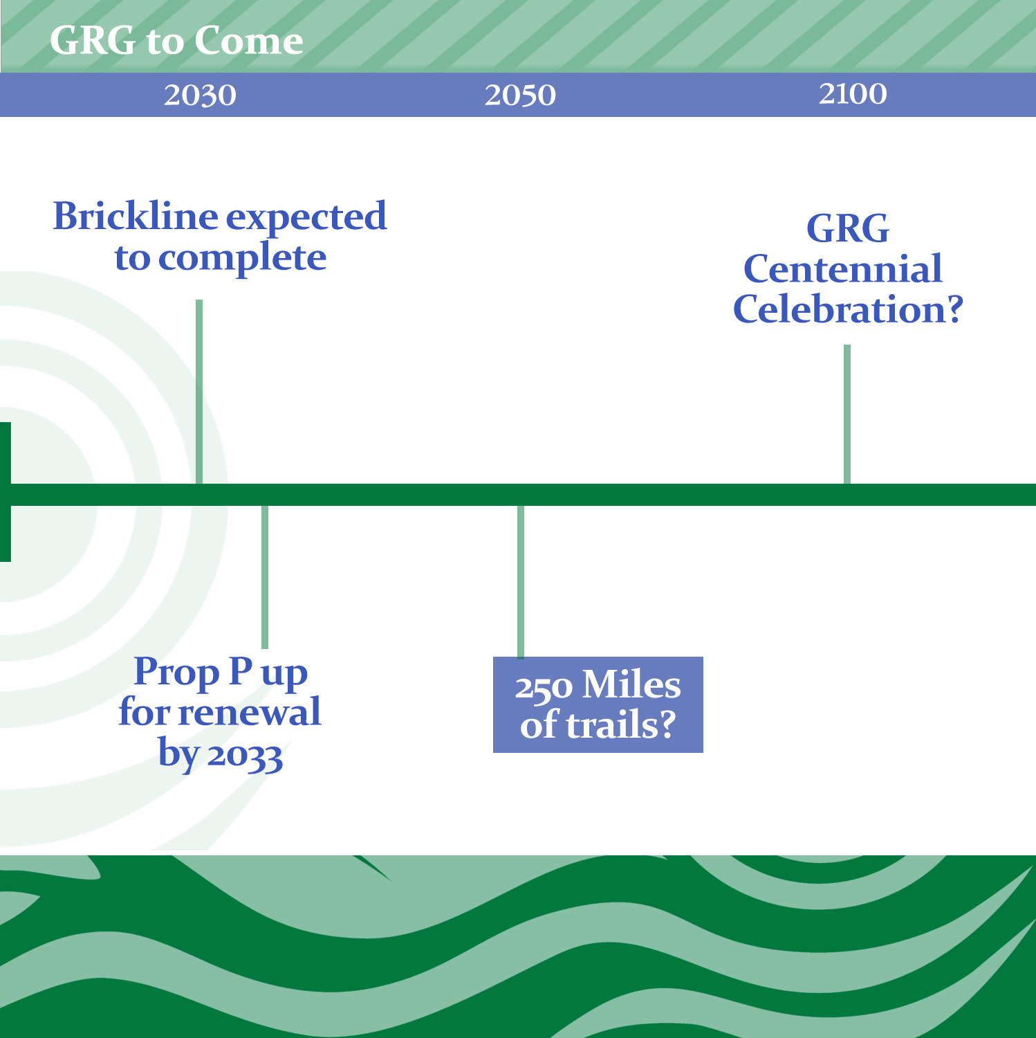
MM: How about the next 25 years– Are the in-progress and in-planning greenways essentially the plan for the next 25? Willing to speculate how the 140 number will grow?
EK: The greenways that are identified as in progress (red dots on map) are in construction, those will definitely be done. The ones that are green dashes, aka future greenways, vary in their timelines. Some of those will get built out in 2-3 years. Some might not happen in the next 25. We have about 25-30 projects in any given budget year, in a variety of stages, and then more are added every year. Similarly to above, nobody can say exactly how many miles will be completed in any given year, but the community will continue to help us figure it out together. And just like some geographic areas have been re-evaluated, it’s possible that some of the lines will change, re-route upon further study, or go away altogether.
Because we did inherit some mileage upon formation (thank you, Trailnet!) and because many of the “low-hanging fruit” options that are/were less expensive are now completed, significantly rising costs of materials and unpredictable economic conditions, I predict we will continue to make great progress but not an exact doubling of miles. My personal, wild guess is that 140 will go up 100 miles to get to 240 by 2050.
MM: Thinking 25 years ahead has me thinking of climate change. Would you say the goals of GRG have shifted any to address climate change?
EK: We continue to hear from people that shade is a priority, and much of the plans for Brickline Greenway (for example) reflect that. Rising temperatures and increased storm events are challenges, so providing shade and mitigating stormwater/flooding are top of mind on every project. Flooding events have become more frequent and more extreme, so that has shifted some of the plans to build right alongside rivers and creeks.
MM: On the disaster tip–Is there anything you can say about how greenways or greenway plans may have been affected by the May 16 tornado?
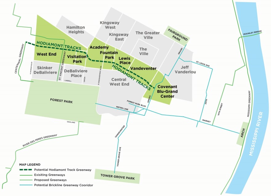
EK: The tornado deeply impacted the neighborhoods that will be home to the future Hodiamont Greenway. So far, the neighbors we’ve talked to urge us to keep going with our projects as planned; they are excited for the investment and improvements. We’ve done cleanups and recovery volunteer days for short-term support, but our main mission remains the same. (Hodiamont Greenway is 3.5 miles across 7 neighborhoods, the Gwen Giles Park/trailhead project is beginning construction next month.)