The Oak Hill Corridor
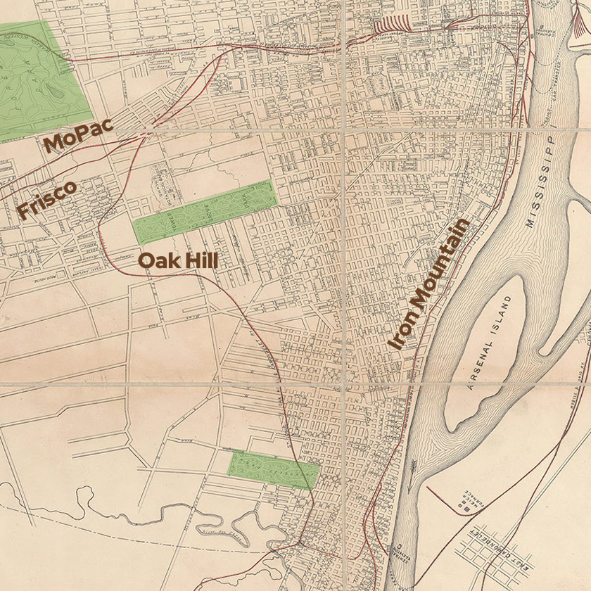
In 1886 a railroad branch was built running south from the Missouri Pacific “MoPac” and St. Louis & San Francisco “Frisco” line near what is now the Hill on land that was just beginning to develop as residences. Dubbed the “St. Louis, Oak Hill, and Carondelet Branch” often shortened to just the “Oak Hill” –the line meandered roughly south from the Hill to Carondelet where it met up with the St. Louis Iron Mountain and Southern or “Iron Mountain” railroad that ran south from downtown along the river.
Industry grew rapidly on the land adjoining the Oak Hill rail–creating a strip of large-scale industrial buildings, while residential areas continued to develop on the tracts just beyond. In 1906 city legislation forced the railroad to go below-grade and began the construction of several bridges to move the rail more easily through St. Louis’ rapidly populating southside. At the time, the railbed carried no less than two tracks the length of the corridor with a network of branches, spurs, and yards to feed the industries that for nearly a century, operated around it.
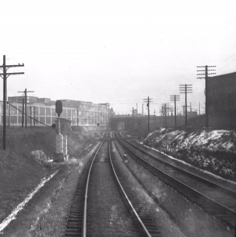
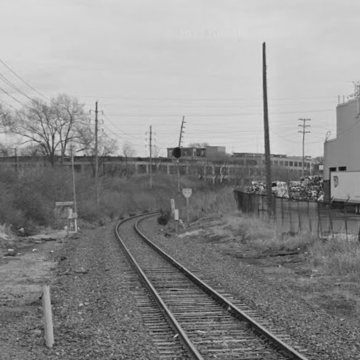
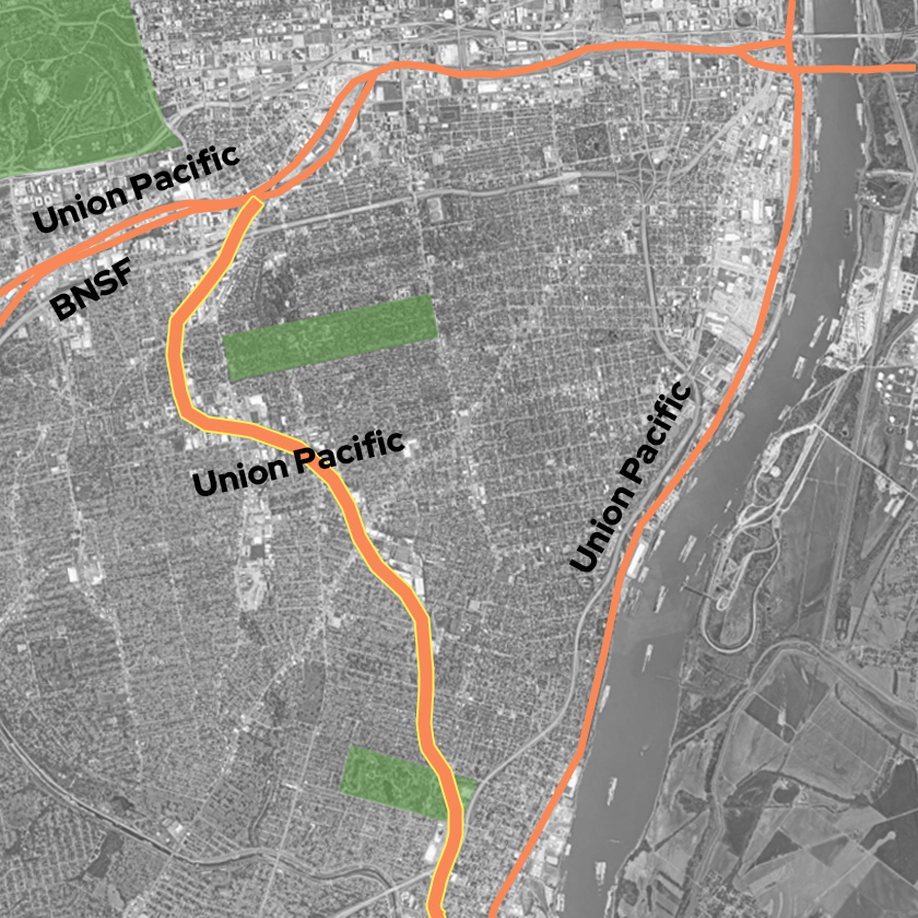
Today that industry has waned. Those railroads have all since consolidated under Union Pacific or BNSF. The spurs, yards, and branches have all but disappeared entirely. The historic buildings, where they haven’t been demolished, are being renovated for office, residential and other uses, actively falling apart, or sitting solid but empty along a rail line that has been reduced to a single track. The track that remains simply takes freight and Amtrak passengers through here, but not to here.
Even as the rail and its industry have ebbed, the space and spaces left behind create a timely opportunity to utilize a century of existing infrastructure– bridges built to protect people, carriages, animals, and automobiles from trains–to instead protect people and bikes from the cars that are increasingly injuring and killing them on streets. A greenway trail built alongside rail in this corridor could connect many of STL’s most populated areas and re-activate historic spaces as the corridor continues to deindustrialize.
Rails With Trails
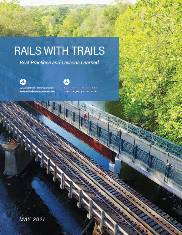
Rails-to-Trails projects like Missouri’s Katy Trail or GRG’s Grant’s Trail, are well used and well known. Less known but steadily growing are Rails With Trails. In fact the Rails to Trails Conservancy states that as of 2021 there are 399 rails with trails in the US, with trails along active rail totalling more than 1025 miles and more being built each year. In 2021 RTC helped USDOT release – Rails With Trails: Best Practices and Lessons Learned, a study loaded with planning resources including relevant state laws, sample licensing and easement agreements, and studies by cities that have already undergone this process. Trails along rail corridors are nothing new it turns out.
Let’s Take a Bike Ride
As I’ve written about previously, the rail corridor that begins south of Downtown and runs westward toward the viaduct at Vandeventer and Tower Grove has exceptional potential to transform underutilized train storage and automobile parking facilities into safe bike and pedestrian spaces in the heart of the city. Our ride begins at the Gateway Arch, and connects those Mill Creek Rail Valley possibilities to the Oak Hill corridor on one continuous 10 mile trail to Carondelet Park that connects to massive trail networks at both ends. Let’s imagine there’s a well kept anchored ebike facility at the south edge of the Arch grounds– we rent a couple bikes, and get going.
Arch to Tower Grove Connector
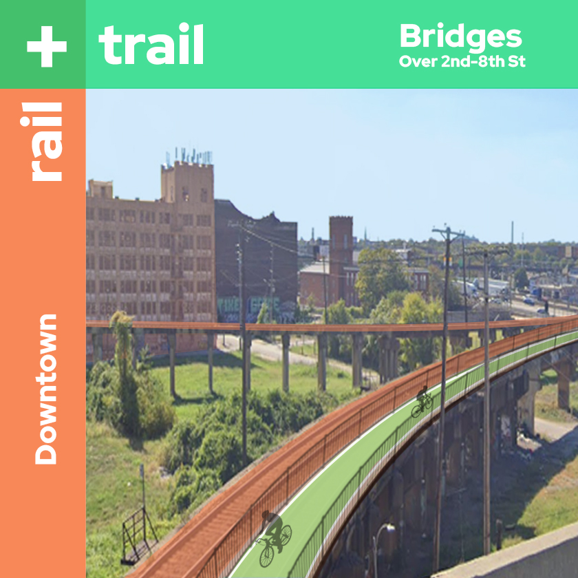
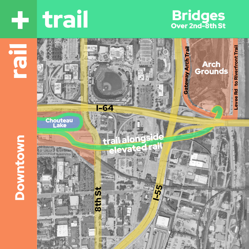
At the south edge of Gateway Arch NP the Riverfront Trail (which winds north all the way to Chain of Rocks bridge and crosses to points beyond) meets the Gateway Arch Trail. Here we take a ramp that loops up onto a bridge that runs west alongside the rail over the new Gateway South development and I-55 all the way to where the rail line dips down again after passing over 8th street, and we ride into the Chouteau Lake District.
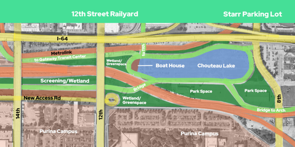
We curve momentarily away from the rail through a park that leads to a lake ringed with trails. We hang right and pedal around the lake. Ahead a small spur can take us to 8th Street where we can exit and head to Ballpark Village, but we continue circling the lake. After traversing the lake’s long north edge, two more spurs emerge, one heads north to 11th street where we could link up with the Brickline Greenway on the Gateway Mall or head to other points Downtown. Another heads west along the Metrolink line to the Gateway Transit Center where there are docks for our bikes. We could take a Greyhound bus, a Metrobus, Metrolink, or Amtrak.
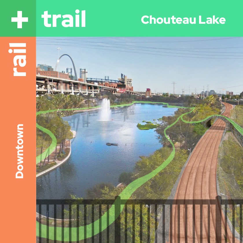
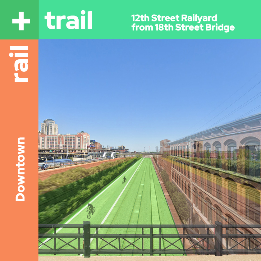
We stay on the trail and loop around a Boathouse at the western end of the lake where we might rent paddle boats or kayaks and get out on the water. Focused on our ride we loop around the end of the lake to a bridge that takes us over the rail line where the trail crosses through a corridor of trees and grasses. We pass under the 12th Street bridge and we enter a lively bike and pedestrian only streetscape spanning roughly eight blocks from 12th to 20th. People walk in and out of shops and eat on the broad patios of buildings at the south edge here as we cruise down a bike lane at the northern edge and under the 18th Street bridge.
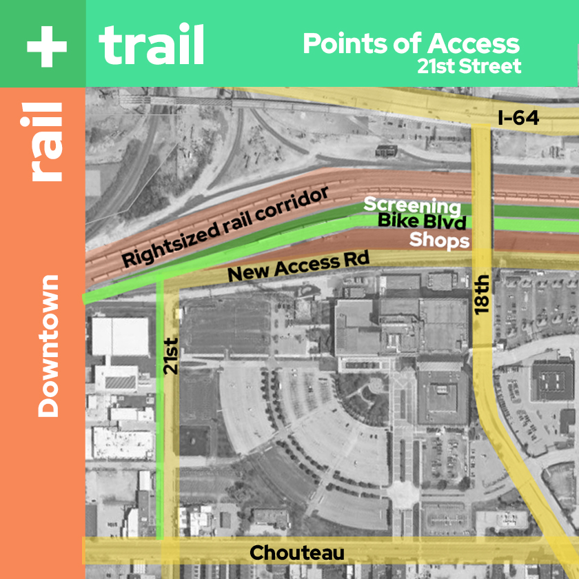
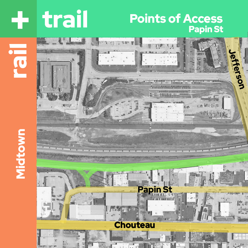
Soon we come to 21st Street where an access road that feeds the shops cuts back between them and the massive corporate campuses to the south. A bike spur here leads to Chouteau where we could suffer cars and ride a bike lane, or cross Chouteau at a signalized crossing on Mississippi and head to Lafayette Park. Instead we continue on, noticing an access just past Jefferson Blvd at Papin. From here we could access Jefferson and the North-South Metrolink or cross Chouteau into the Gate District Neighborhood.
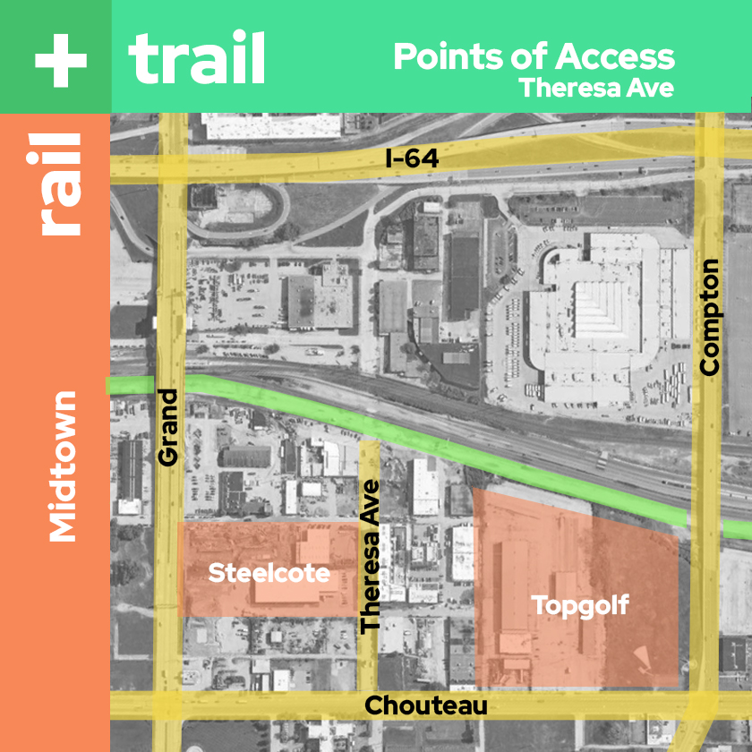
We’re making good time when we pass under the Compton Ave bridge and find another connection at Theresa Ave. We might stop at Topgolf(but probably not) or do some shopping at Target, or maybe you live or know someone at one of the new apartments here? This would be our best access to cross the bridge at Grand and catch the Metrolink or visit the City Foundry or Armory.
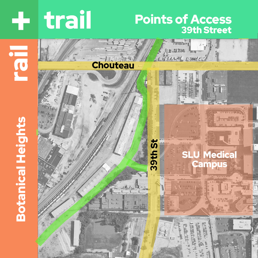
We push forward under Chouteau and notice an access to the trail that emerges on 39th behind the SLU medical campus. We think “Would SLU build more than just giant parking lots here if they were connected to a trail network?” As we head west toward Tower Grove Ave we debate the trade-offs of giving large chunks of urban land to corporations and universities. From the trail we see empty lots along Park Ave, just outside the scope of SLUs redevelopment zone. Could new residential work there?
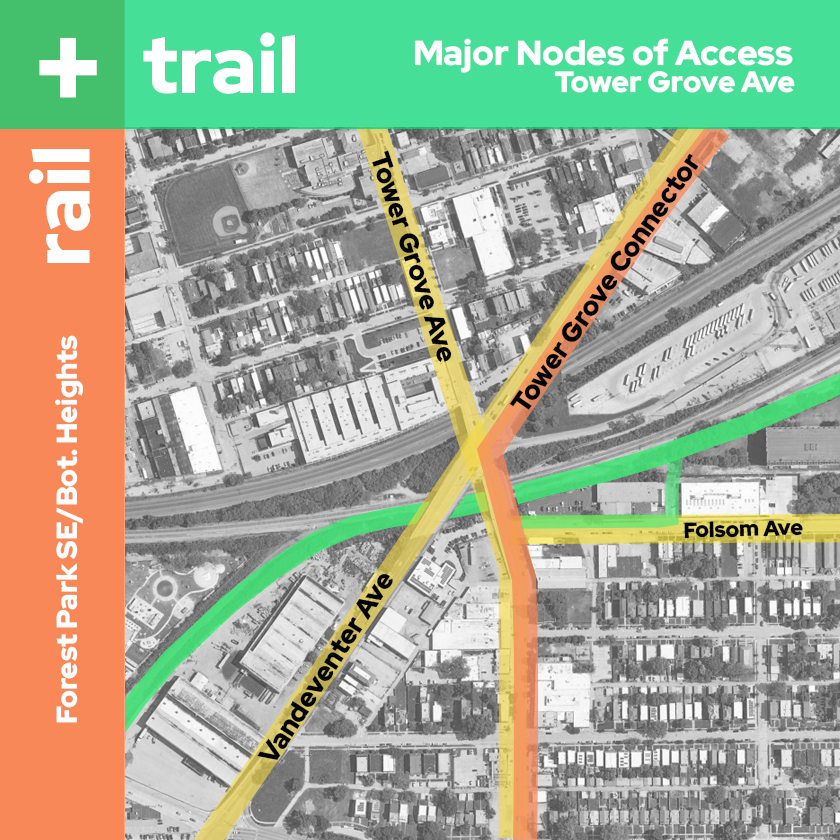
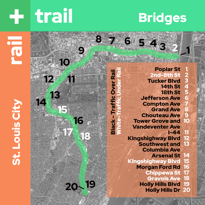
Fifteen minutes or so into our ride we approach the viaduct that carries traffic over the rail at Tower Grove and Vandeventer and an access opens to the left that cuts by City Garden Montessori School and onto Folsom Ave in the Botanical Heights Neighborhood. A parking lane on Folsom converted to a protected bike lane leads to Tower Grove Ave and the Tower Grove Connector. That could take us north through FPSE and the Grove all the way to Cortex where it links up with the Brickline or South to Tower Grove Park. As we go under the viaduct you ask me how many bridges are on this trail. It’s 20. Most take traffic over the rail, but a few take it under.
Tower Grove Connector to Fyler Bike Park
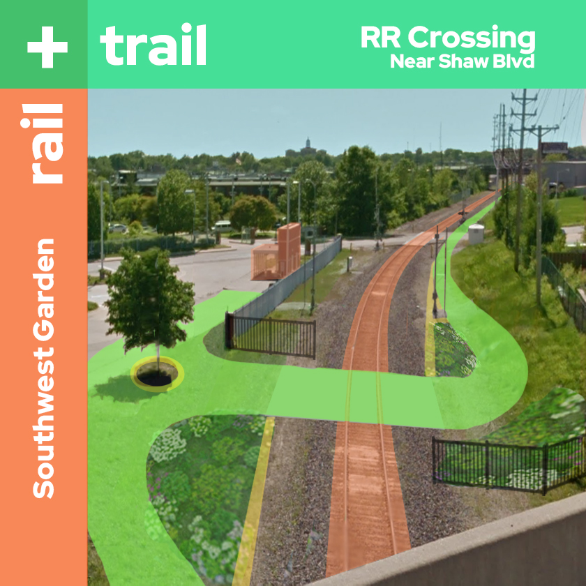
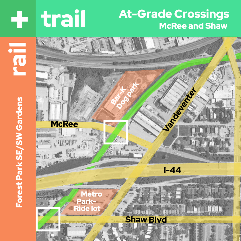
We veer southward and notice Bar-K Dog Park on our right. You look back to the trail and then notice it: The first at-grade crossing at McRee Ave. It’s scary but signalized. We stop and let traffic pass and then take our turn. We hear the roar of traffic overhead as we go under I-44, and then come upon a connection to Metro’s Park-Ride lot at MOBOT on our left and an RR crossing on the right. You ask “Did we just ride all the way from The Arch to the Botanical Gardens and cross traffic only once?”
Bike docks here could hold our bikes if we wanted to stop at the gardens. This would also be a pretty good place to take a bus, or access the trail by driving. Traffic arms are open at the crossing so we cross the tracks to the west side which will be the only time we cross them. You ask if trains even come this way. I tell you Amtrak sends one train a day through here Northbound around 6am and Southbound around 7pm on the Texas Eagle line. Freight trains use it about as often as far as I can tell. We cross at-grade again at Shaw Blvd, roughly halfway to our destination at Carondelet Park, and head south into the densely residential South City.
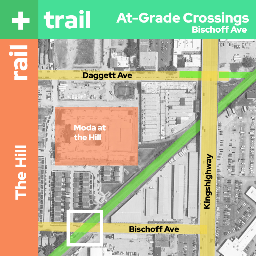
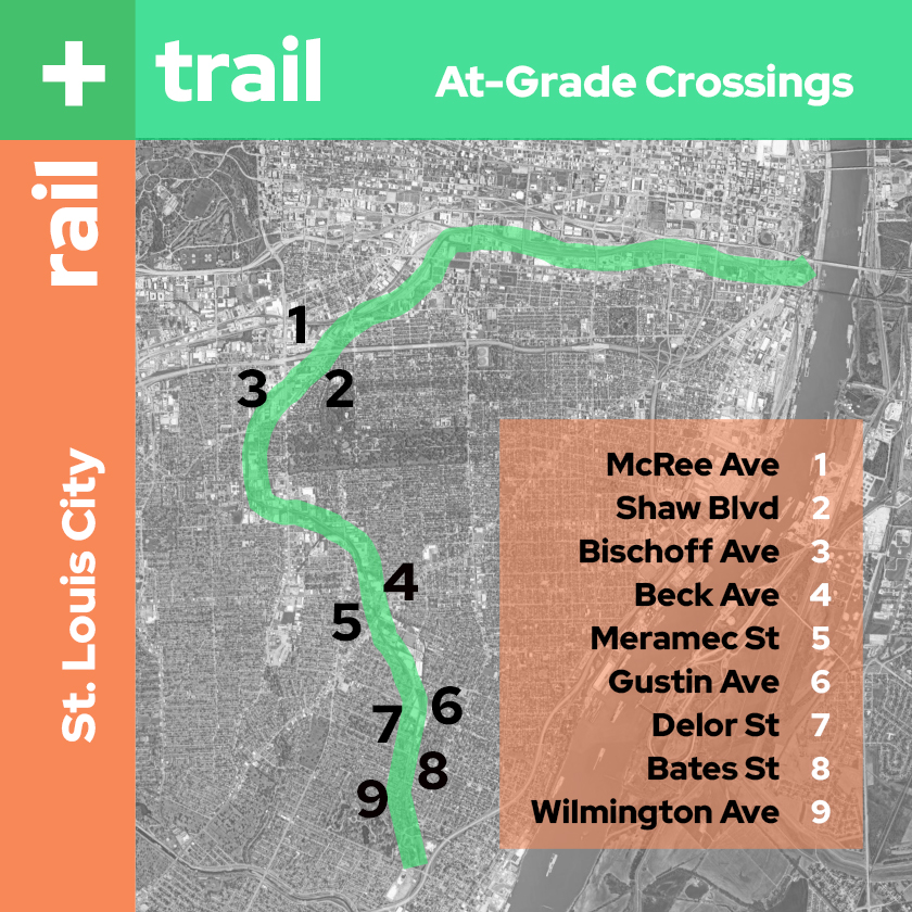
Just before going under Kingshighway, an access on the right leads to Daggett Ave that can take us into the heart of The Hill Neighborhood and all its great restaurants near the new Moda residential complex, and newly renovated law offices at the old Magic Chef Factory. We cross under Kingshighway and come to another at-grade crossing at Bischoff. You ask if there will be many more of these. I tell you there are 9 total on our way to Carondelet Park, and that this is the last one for a few miles.
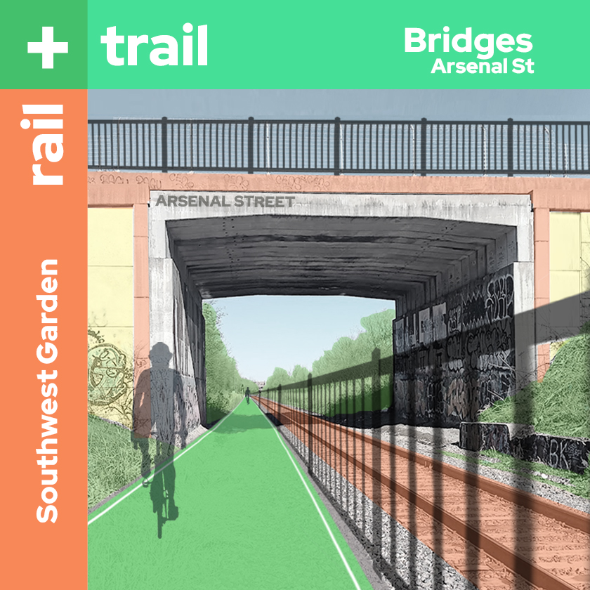
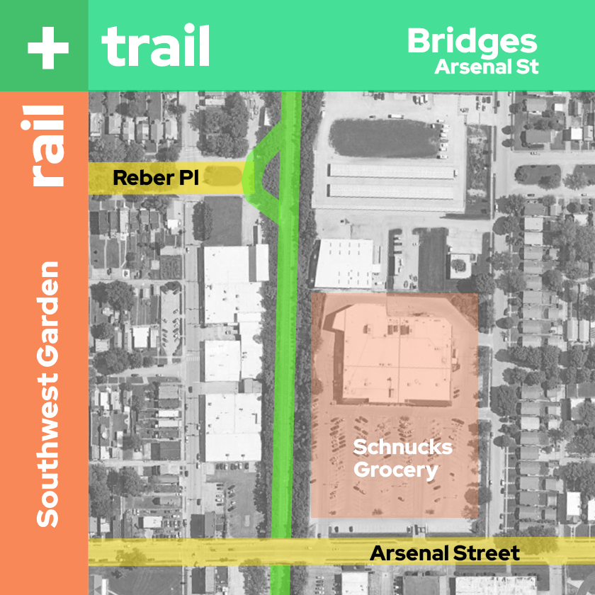
We leave the Hill, crossing under the bridge at Southwest Ave and enter Southwest Garden. An access ramp leads up to Reber Place where we can enter the neighborhood and get to Sublette Park. This would also be a good place to access the Schnucks Grocery on Arsenal St. We pass under another bridge at Arsenal and keep heading south.
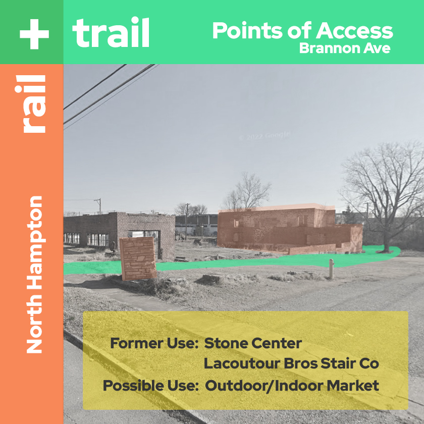
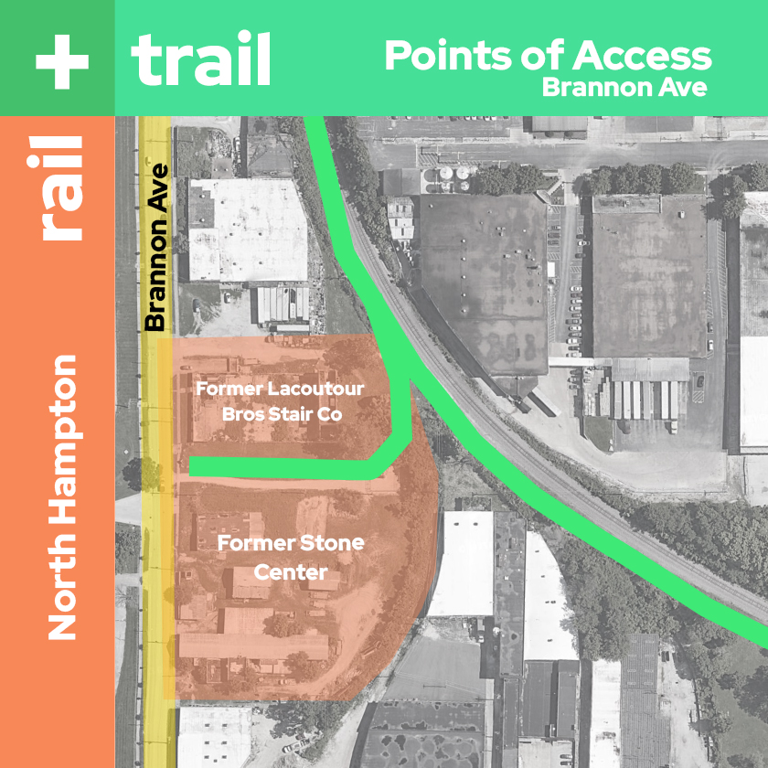
Just past the bridge we find another point of access at the former Stone Center in North Hampton now an indoor/outdoor market and events space for the neighborhood and an access to the trail. We could exit here and go to the South City YMCA, Tilles Park, or one of many schools in the area.
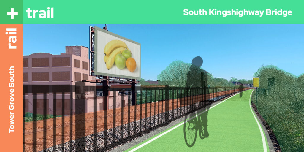
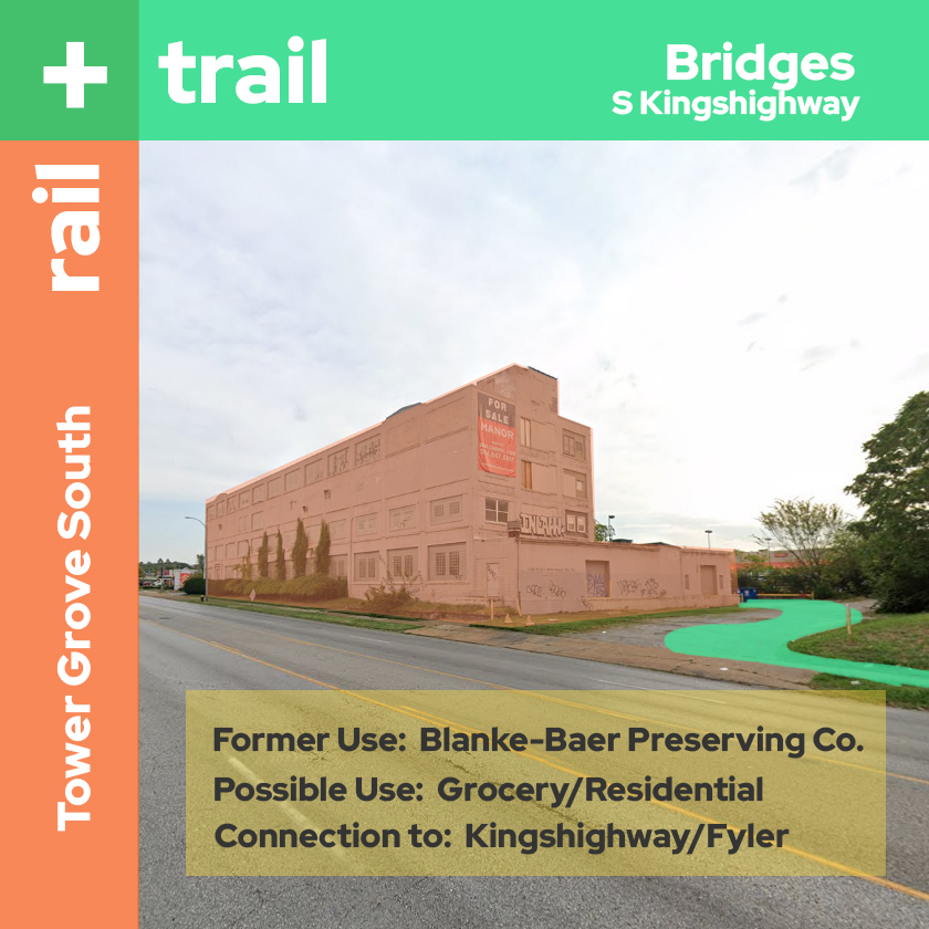
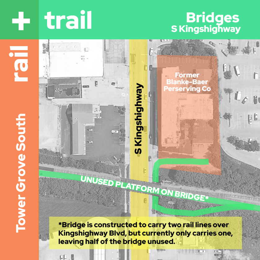
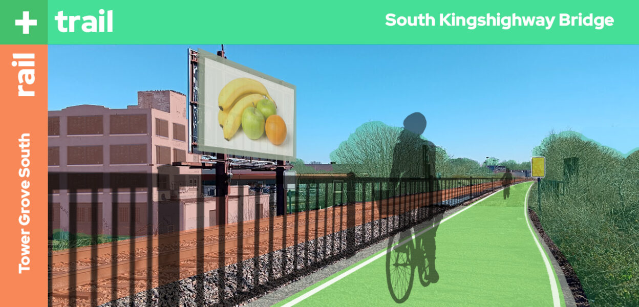
Rounding the corner we see the South Kingshighway rail bridge where the trail uses the previously unused south platform. This takes us safely over the busy traffic of Kingshighway into the Tower Grove South Neighborhood. The former industrial building on our left adjacent to the Home Depot parking lot has been converted to a grocery with residential above. We could access South Kingshighway on bike from here, but we both know that’s a death sentence.
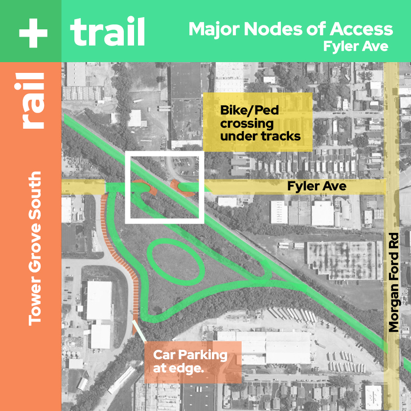
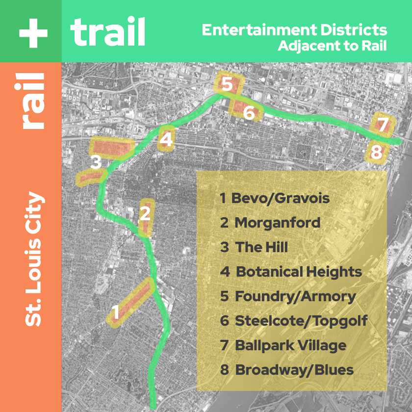
Soon we can make out a greenspace through the trees on our right. A break in the trees reveals a bicycle oriented park on 8 acres that was long ago a home to a concrete plant. We take this detour and follow a path through the park to Fyler Ave where there is a short tunnel beneath the rail reconnecting Flyer east and west of the tracks for bikes and pedestrians. You notice we are only a block away from the southern end of the growing Morgan Ford entertainment district. I rattle off a list of other such districts that are adjacent to this corridor while we loop around and get back on the trail.
Fyler Bike Park to Carondelet Park
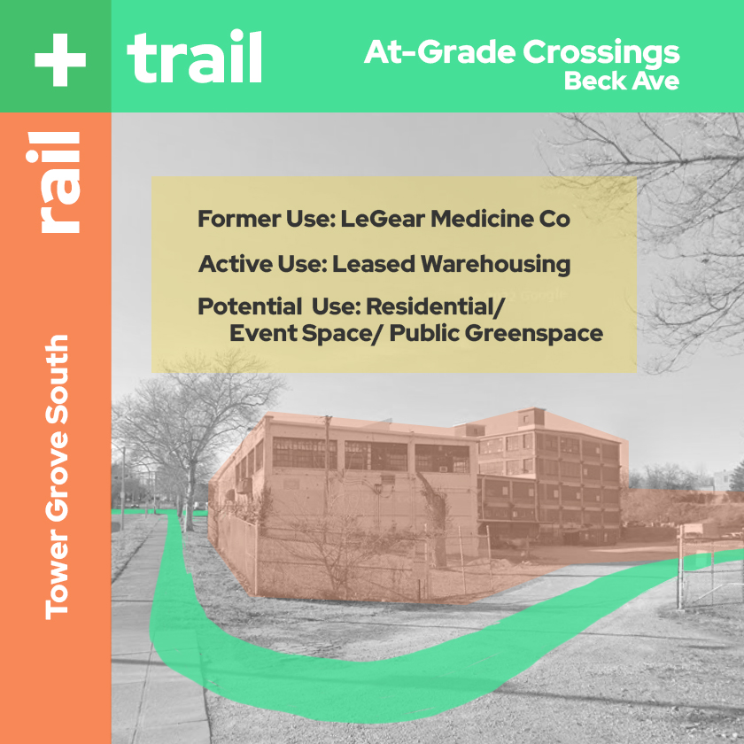
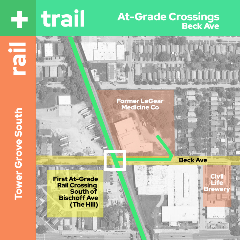
Continuing south we come upon our first at-grade crossing south of the Hill at Beck Ave. The historic former industrial building at Beck Ave has been converted into a residential building with a broad lawn. Less than a block away I point out the outdoor beer garden and brewery Civil Life at the southern end of Tower Grove South. Maybe on our way back?
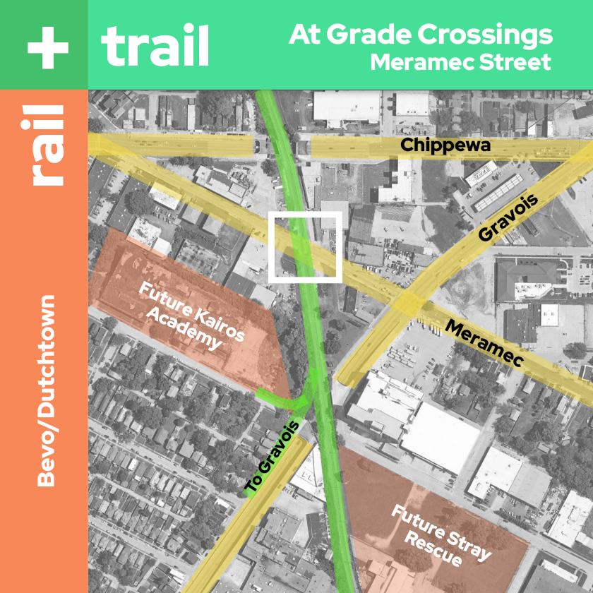
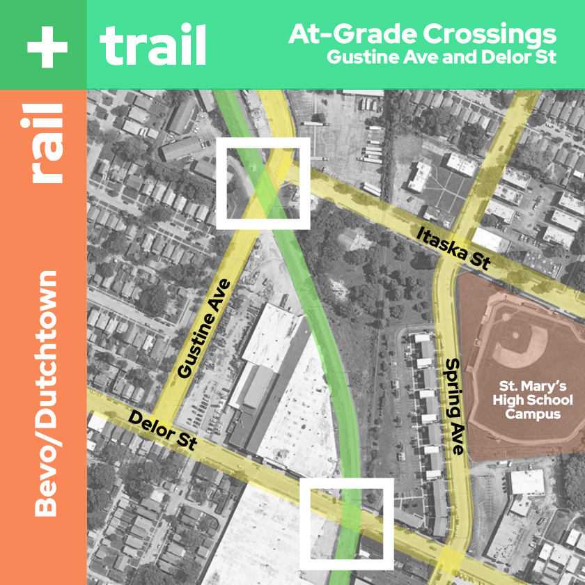
From there we cross a bridge over Chippewa, cross Meramec at-grade, and then over Gravois where two spurs lead directly to the site of the new Kairos Academy School and down onto the bike lanes of the Bevo dining and entertainment district on Gravois. Moving on, we pass the Stray Rescue’s new campus on the left before approaching more at-grade crossings at Gustine and Delor adjacent to the St. Mary’s High School campus off Grand that could take us into Bevo or Dutchtown.
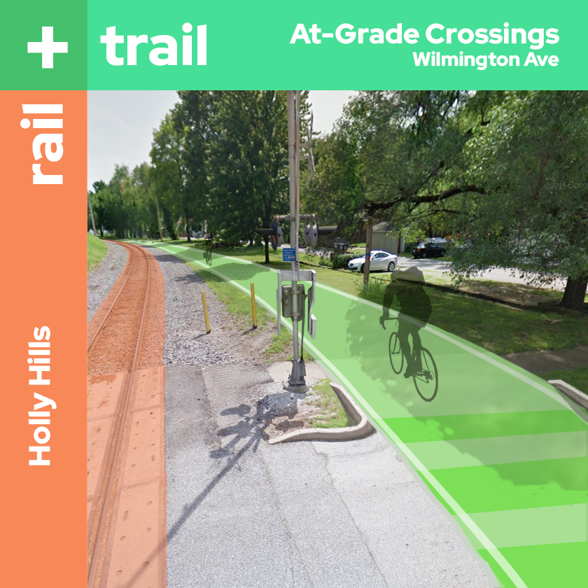
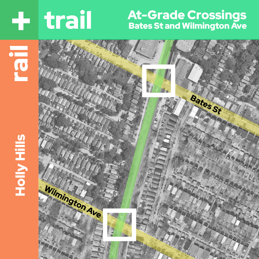
Crossing Bates we leave the last Industrial buildings (some active, some vacant, some transitioning) and the trail runs through the greener residential subdivisions of Holly Hills crossing at-grade one final time at Wilmington before we make it to our destination.
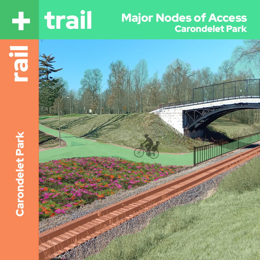
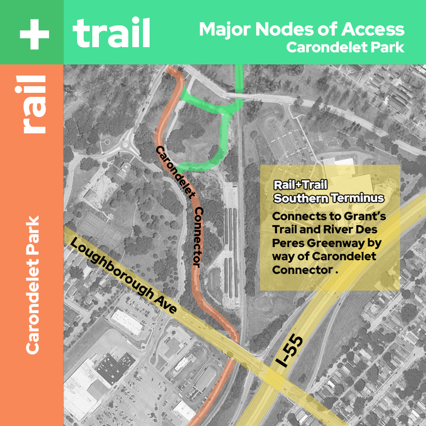
Passing under the bridges at Holly Hills Blvd and Holly Hills Dr we emerge, finally, from the rail corridor into Carondelet Park–10 miles and probably less than an hour from our starting point at the Arch. We stop at the connection to the Carondelet Connector, drink some water, and take in the beautiful scenery of the park. “Where from here?” you ask.
I tell you the Carondelet Connector will take us to the River Des Peres Greenway. Five miles up that trail and we could catch Metrolink at the Shrewsbury stop and take that right back to the Arch if we like–or take it further through the connector trails and go all the way to Forest Park and the Brickline. A short jog east on the trail instead, and we can ride along the river to Jefferson Barracks Park. We could also take the Grant’s Trail and ride another 10 miles through Affton and Grant’s Farm to Kirkwood. But we’ve done enough riding for right now. We dock our bikes here, stretch our legs, and take off walking the trails of Carondelet Park.
The Future is Multimodal
Recently I happened upon a new STL-based urbanism podcast “Overarching.” The show’s creators released an episode earlier this month where they discuss their dream Metrolink line which also happens to run along the Oak Hill corridor (find their discussion here around the 45 minute mark). There certainly is room for both (Light Rail+Trail) if the corridor could be had from Union Pacific. While railroads like U.P. are notorious for hanging onto their tracks, they also own the active former Iron Mountain line that runs south from the Arch and meets back up with the Oak Hill line in Carondelet south of the park, making the Oak Hill line potentially redundant.
Among the many ideas moving forward concerning how the city may use the money from the Rams settlement is one for “Protected Bike Lanes and Bicycle Network”. St. Louisans can go here to vote on which ideas they like best.
STL’s many planned bike facilities projects that include protected lanes for cyclists are a must. But where there are cars, there is danger. Trails and greenways that can take bikes and pedestrians out of conflict with drivers entirely are a way to get timid cyclists like myself and cyclists that have lost faith in drivers back on our bikes. Rare is the opportunity to do that in an urban context that connects so many residential, business, entertainment, and tourism areas and could help us adaptively reuse so many historic buildings and vacant or underutilized lots. As St. Louis updates our Transportation and Mobility and Strategic Land Use Plans we have a chance to think big on a future that’s not just about cars.
