
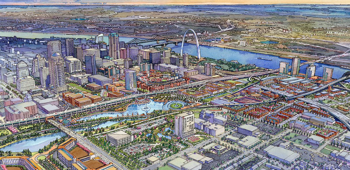
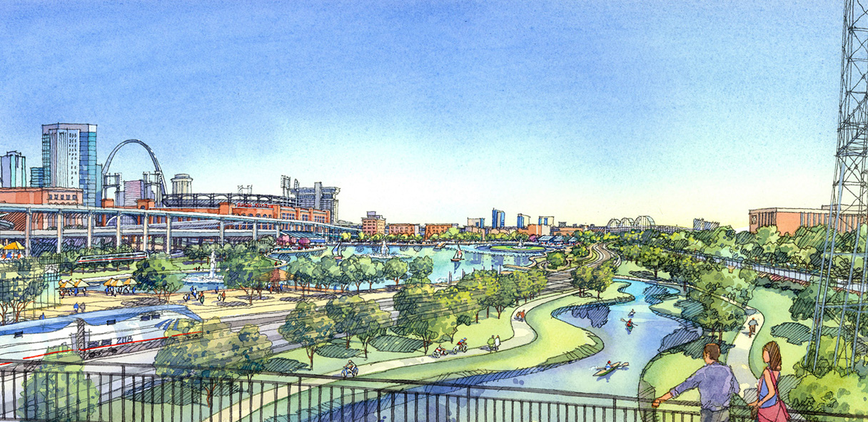
Twenty-Four years ago St. Louis based real estate development firm McCormack Baron (now McCormack Baron Salazar) released a plan to transform the Mill Creek railyard valley near downtown. The plan included two lakes, urban wetlands, bike trails, office, retail, and residential development within a 195-acre footprint running south of Interstate 64 along the rail corridor. Like many plans from its era, it sought to create a technology district that would create thousands of jobs for St. Louisans, alongside billions in investment and development over a 25 year period.
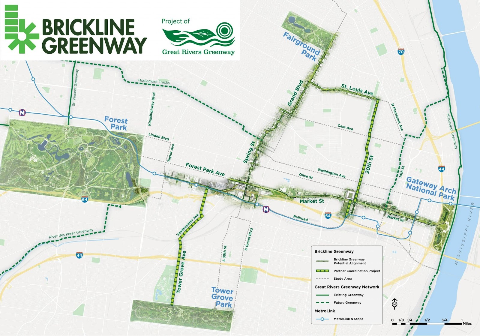
Nearly 25 years later, most of that dream remains unrealized. In the years since (and thanks in large part to its influence) Great Rivers Greenways has emerged as St. Louis’ prime player in creating green urban infrastructure, and much of the early zeal for what was originally billed as a Chouteau Lake and Greenway, has transformed through numerous plans into the Brickline Greenway, an expansive and ambitious plan to link many of St. Louis’ cherished institutions like Forest Park, The Gateway Arch, Tower Grove Park, and Fairgrounds Park, with urban bike and pedestrian infrastructure that nonetheless avoids the rail valley.
Even so, thanks in part to new developments in Midtown like IKEA and City Foundry, as well as long existing light and heavy commuter rail infrastructure, proximity to SLU, the popularity of the Grove district and numerous other factors, retail and residential development and redevelopment are either planned, in construction, or complete along the rail valley and at the South Riverfront.
With this in mind–and while taking into account the crisis of bike and pedestrian injuries and fatalities, planned bike infrastructure connecting GRGs emergent Brickline to the region-wide trail system, and MoDOT’s planned restructuring of I-64 interchanges between Kingshighway and Jefferson (There is an open house Jan 18th) –I want to take a look back at this influential plan to discuss what it may still hold for St. Louis.
Chouteau Lake and Greenway Plan
If a formalized plan existed for the Chouteau Lake and Greenway, outside of the detailed maps and renderings that remain (either on McCormack Baron Salazar’s site, or through some iffy internet digging), that plan is no longer readily available to the public. The goals of the plan here then must be inferred from the images themselves (a little digging unearthed this slideshow) and from the descriptions that remain on MBS’s website.
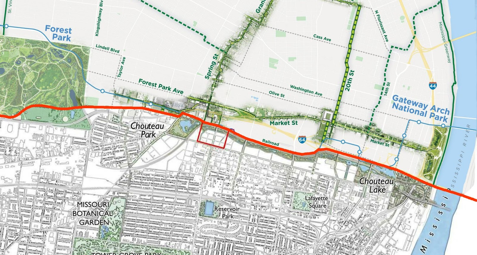
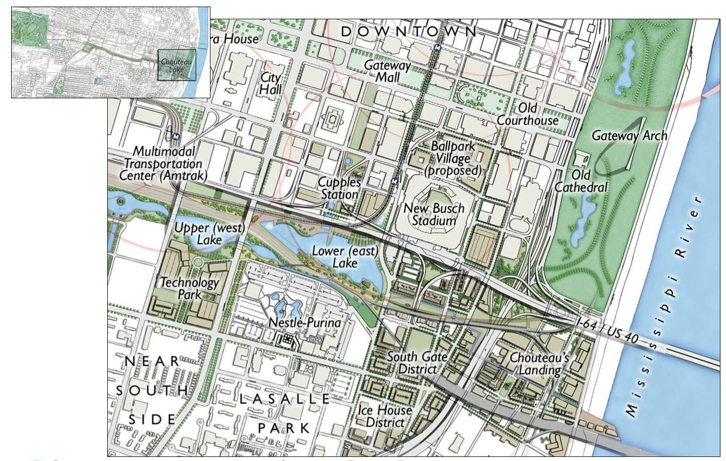
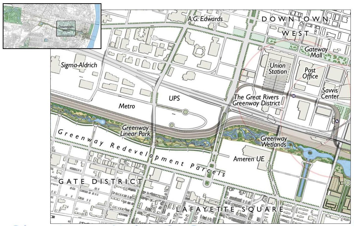
The focus area of the plan has 8th street at its east, I-64 at its north, Chouteau Ave to its south and Vandeventer Ave at its west. At its east end two lakes south of Downtown between 8th and 14th rest between rail infrastructure, park space, and housing and office development.
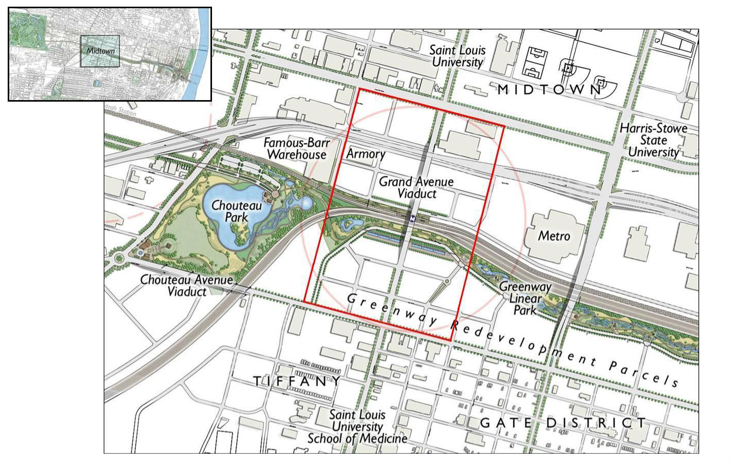
From 14th street west, a long corridor of wetlands and linear parks with bike and pedestrian infrastructure snake west to Vandeventer on the south edge of the rail line (consolidated on the northside of the valley) to create nearly 3 miles of continuous greenway. At the south side of the valley, the plan marks space for redevelopment.
At its western end it imagines a large Chouteau Park with its own lake and walking paths. Additionally, it imagines bike corridors west to Forest Park along Clayton Ave, and south to Tower Grove Park along Vandeventer and Tower Grove.
The plan could be said to have three main objectives: Economic Stimulation , Environmental Restoration, and Remediation of Disconnection. Each could be said to contain a number of key goals with predicted outcomes.
Stimulate Economic Development
- Develop tech-friendly office infrastructure and engage with current businesses within project footprint (Ameren, Ralston Purina) – project estimates 7 billion in investment and “tens of thousands” of jobs.
- Develop residential directly along urban lake and greenway –project estimates 8k-10k residential units in its greater 1,950 acres “impact area.”
Environmental Restoration
- Restore or remake some portion of the historic Chouteau’s Pond which once existed in this context and create parklands and wetlands along a corridor to the west of the lake(s) which will reduce stress on sewer system by gathering storm water runoff into a wetlands that replace impervious surfaces and beautify an otherwise blighted industrial zone.
Remediate Disconnection
- Connect nearby areas to the focus area by way of bike and pedestrian connections and greenways toward increased use of transit options and bike and ped infrastructure in the core of the city.
- Build across the footprint of the focus area to reconnect downtown with neighborhoods to the south and vice versa, and connect to Chouteau’s Landing.
Critical Lens
The Chouteau Lake plan was an exciting prospect that clearly inspired many in St. Louis to get to work creating a more bike, pedestrian, and environmentally friendly corridor. Though the Chouteau Lake plan has in many ways transformed by degrees into the Brickline Greenway, the two plans no longer have a great deal in common and do not necessarily address the same challenges or functions. After some 24 years, the Chouteau Lake plan deserves re-evaluation both separately and in addition to the Brickline’s planned improvements. Decades later, the challenges that have kept it in check should be re-evaluated, and its advantages should be reconsidered in the context of a quarter-century’s developments. Instead of a formal critique (of an aging plan that is apparently missing a formal description), I will focus on these challenges and advantages here.
Challenges
A large portion of the project footprint is occupied by a large surface parking lot south of Ballpark Village and the Ballpark and Cupples Station Lofts. That portion of the area appears to be owned by Great Rivers Greenway, making a substantial portion of the footprint available to such a project, at least in theory, and accounts for most of what would be the plan’s easternmost lake. However, a portion just as large is still occupied by Union Pacific’s railyard just to the west.
The accepted reason for the project’s demise appears to be the railyard’s right-of-way. United Pacific appeared to be unwilling to part with their tracks. However, it doesn’t seem to be that simple. Early on in the process, way back in 2001, Stephen Mulvihill, MBS’s then vice president, stated that United Pacific was on board with intention to reduce their tracks in the area to three. It may in fact be that this is no longer the case (if so I’m unable to find record of their saying as much.) Perhaps the railroad is unwilling to incur the cost of removing or relocating tracks, or unwilling to endure construction related setbacks. These are related obstacles which to my understanding don’t constitute a “no”, but instead an “if”.
But if rail lines are the project’s biggest obstacle, they are also perhaps its greatest advantage. Because of the right-of-way of the rail lines in the valley, no auto traffic roads cross it between the river and Macklind Ave. Instead, numerous bridges or viaducts take traffic over the valley between its north and south side. This advantage suggests one of the area’s other great opportunities–a traffic free bike and pedestrian corridor.
Imagining a Traffic Free Corridor.
Imagine you’re a resident, if you’re not already, of one of the many new apartment buildings going up in the Grove neighborhood, or in developments in Midtown near City Foundry, Steelcote Square or Edwin, or even in an imagined Chouteau Lake District. You like to ride your bike, and it’s a short ride, perhaps, at auto-traffic grade to a ramp that leads down into a rail valley where dedicated bike and ped lanes entirely free of traffic crossings will take you to retail amenities down in the valley itself as well as to a large destination park just south of Downtown. You take the trail along the rail, then along a wetland greenway. You hang out in the park beside a lake that reflects the nearby trees and the skyscrapers beyond. You do whatever shopping you need to do and return to your apartment on your bike or perhaps a rideshare bike and while you must navigate the many cycles, pedestrians, and probably scooters along the path, you never have to worry if cars on the road see you or indeed care at all about your wellbeing.
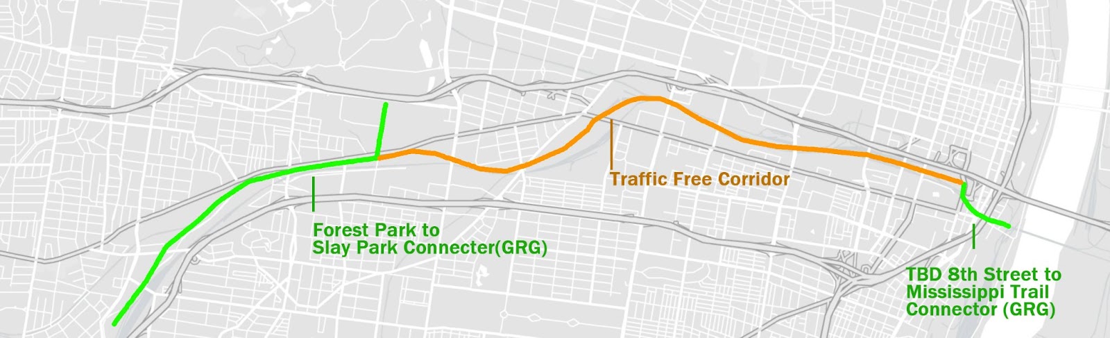
At this imagined corridor’s eastern end it connects to the Riverfront Trail with GRGs planned connector starting at 8th Street (in the proposed Gateway South neighborhood) taking you to the riverfront and points north. At its western end it connects to GRG’s planned Slay Park to Forest Park Connector, which connects with River Des Peres Greenway and points south all the way to Carondelet Park, all trails with little traffic crossing.
A Safer Alternative
Critics have pointed out that dedicated trailways such as this take people away from the amenities they want, which exist along at grade streets. To some extent the newest designs of the Brickline (above) bear out this criticism and endeavor to make room for bike and ped access along and across automobile lanes. It’s a valid criticism perhaps, but with the rate of automobile related bike and ped injuries and fatalities in the city, an alternative ought to be offered. If we can bring amenities to dedicated pedestrian and bike infrastructure, and connect it to a growing housing and retail market along a traffic free corridor, I would wager this would create its own virtuous cycle (no pun intended) of continued development. Side benefit for the preservationists–building infrastructure along rail means unused buildings once used for shipping and warehousing are ripe for conversion into housing or other adaptive reuse. Rail-to-trail means warehouses-to-homes.
A Plan Ahead of its Time
These ideas aren’t entirely new, some version of this exists in the many plans created for GRGs Chouteau Greenway Design Competition–the crux at which the long dormant project stopped being about the rail valley, and became about bike infrastructure in the city proper and connections to a clamoring southside, and equitable connections for a hopefully rebounding northside. I’m excited to see these projects happening, but they don’t address the valley much at all. Brickline additions aside, the promise of the 1999 plan remains in the valley and along the rail corridor.
If this promise is to be considered, the apparent mission drift from Chouteau Greenway to Brickline Greenway needs to be acknowledged so that the growing opportunities of the original Chouteau Lake and Greenway plan aren’t disregarded in the meantime. If the plan’s rail challenge is possible to overcome, it’s worth asking what there may be to gain.
This is especially timely now as MoDOT is soon releasing planning options for how I-64 will interface with the city between Kingshighway and Jefferson Blvds. When considering these options, we should be wondering how they might affect the possibility of a Chouteau Lake District, a dedicated bike and ped way, and all the advantages that this might bring, and not focus merely on Midtown’s exciting developments, and the Brickline’s path. Choosing the wrong one could mean denying this underutilized area the potential outlined in this inspiring and ahead of its time plan, and the infrastructure that could help transform it.
