In January of 2015 Great Rivers Greenway began work on a plan to redevelop the North Riverfront. Because the Rams NFL ownership was threatening to leave St. Louis unless a new stadium was in their future, GRG and urban design firm Forum included an alternative plan to incorporate a new stadium along the riverfront. That July, the plan was released to the public, and the stadium, the possibility of the city paying for it, and the Ram’s future in STL became the focal point of public discussion around redeveloping the North Riverfront. As we all know, even as early January of 2016 it was clear the Rams would be leaving St. Louis. While there’s no doubt the inclusion of the stadium and the loss of the Rams put a black mark on GRG’s ambitious plan, it has remained the best document around which developing the NRF can be discussed.
Somewhat surprisingly, St. Louis City and County won a $790M 2021 settlement against the NFL for improprieties concerning the team’s move. As the city and county decide how they will divvy the roughly $500M after attorney fees, it seems timely to take a look back at that North Riverfront Plan and discuss what still works, what doesn’t, what’s missing, and what has changed in the intervening seven years.
Revisiting GRG’s 2015 Plan
The plan presents Nine strategies for developing the North Riverfront (NRF):
- 1 Engage the River
- 2 Connect to the Central Riverfront (Arch Grounds)
- 3 Enhance Viewshed (create views of river, arch grounds, city skyline)
- 4 Extend the Green Network
- 5 Leverage our New Front Door (Musial Bridge)
- 6 Strengthen the Street Grid
- 7 Link to Public Transit
- 8 Catalyze Existing Building Fabric
- 9 Harness the Energy of the River
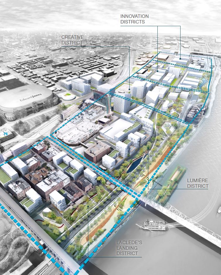
To this end, the plan creates 4 distinct districts–(working south to north) Laclede’s Landing District, Lumiere Casino (now Horseshoe St. Louis) District, Creative District, and an Innovation District composed of two smaller districts, within the broader 180 acre North Riverfront District (roughly twice as large as the arch grounds) which, collectively, are bordered by Eads Bridge at the South, Stan Bridge at the North, Hwy 44 at the West, and the river at the East. An open space park runs along the entirety of the project on the eastern side and is described in an Open Space Plan. The plan also includes a Riverfront + Stadium option in which the stadium and its parking occupy the entirety of the two northernmost “Creative” and “Innovation” districts. I would suggest reading it yourself, if you haven’t already. It can be found here.
Critical Lens
I want to preface by saying this is quite an inspiring plan overall, one that addresses a number of daunting challenges any plan for the NRF would face. It is precisely because it is the best thing going, that I think it is worth addressing in greater detail, if only as a reminder of the NRF’s potential as other parts of the city see an uptick in development
My modest critique favors the historic, the environmental, and the civic. I have little to criticize in the way of the proposed park spaces, only that they be slightly larger and better oriented to take advantage of the river. My reimagining of the plan seeks to re-align key spaces, particularly in the “Innovation District,” toward civic use in line with the NRF’s connection to the Gateway Arch, and to better address the challenges and opportunities of the flood wall at this location.
With that in mind I want to discuss with specific examples:
- What in the plan could be improved?
- What’s best about the plan?
- What’s missing?
- What is already there?
- What has changed in 7 years?
What in the plan could be improved?
Specificity. Reliance on buzzwords as ideas e.g. “collaboration park” “innovation district” “creativity lofts” instead of proposing specific intentional uses. This particular criticism has a couple fronts. First, people want and need concrete ideas of what would happen in any given space to consider–this is partly why the stadium became such a focal point of the plan in 2015. Secondly, on the civic front, while these names buzz with cool digital utopianism, they reorient the ideas around the spaces back toward private industrial/office use. This is particularly true of the…
Innovation District. The innovation district in particular (and to a lesser extent the Creative District) seems less purposefully conceived. Framing this space as “innovative” essentially feels like a call to tech industry giants like Amazon to occupy the space, or perhaps more realistically, signaling development for smaller scale tech incubation. The Amazon ship has of course sailed and tech incubation is happening elsewhere in the city. Additionally, lack of available office space is not a problem downtown currently has. Perhaps more importantly, working from the arch grounds, this district becomes the terminus of the plan, and thus needs to be a destination that will attract people across the entirety of the project. A tech industry hub instead walls it off.
Too much focus on office/residential and not enough on parks/ tourism. While there is room for both, the focus on parks and tourism should take precedence. Major highways send visitors through the area. The Gateway Arch attracts them to stop. Those visitors need a reason to stay at the riverfront. The city should utilize as much of this space as possible toward expanding and enhancing this destination. Parks and destinations will in turn attract residential and retail development along its western edge. Additionally, those developments should be pushed back west of 1st Street, creating a larger and more continuous open space park. Existing vacant buildings within the footprint of the park should be adapted for civic use. Buildings and businesses already active within this footprint, should of course be respected.
Not enough access to the river. The plan seeks to offer access to the riverfront, but it never fully addresses the problem of the flood wall. From Carr St. north, the flood wall obstructs views and access. The plan smartly reorients the space back inward in the Creative District where access is fully restricted by the Ashley Energy building, but then never addresses it going north. A better plan would address these problems more fully.
What’s best about the plan?
Riverfront Park. With little exception, the open spaces conceived in the plan are pretty thrilling. While they aren’t fully fleshed out, the renderings appear to offer a complex network of walking paths, natural spaces, and structures with an appropriate human scale (as opposed to the arch grounds, it must be said). They also appear to transition smoothly in the southernmost districts to the riverfront where you will find a…
Barge Park and Boat Launch. The idea of interchangeable barges as parks and restaurants is a perfect reuse of existing machinery, a cool historical reference point, and a way to get out into the river space. If successful it would be a catalyst for new business, and a unique destination that would bring in outside folks. The plan suggests that similar barges from cities like Minneapolis or New Orleans could swap out with our own locals, creating connections with other great cities along the river. Others have recently pointed out that St. Louis needs a marina. That would appear to fit well into this plan.
Mounds. Mounds are just plain cool, but also they can be a symbolic counterpoint to the arch and its questionable memorializing. The plan locates several former Mississipian mound sites along the riverfront, and suggests a mound park near some of those sites beneath the MLK bridge, and a larger mound near the northern terminus.
River Research Center. A river research center is suggested in the Creative District. While it seems a bit out of place where it has been positioned, a cultural institution which studies and interprets the river seems like a no-brainer in this context.
Parking lots to garages. The current state of this entire area is a mess of parking lots. Strategically placed garages that stay off the riverfront itself would be needed to ensure people can access the space.
What’s missing?
A worthy use for the Cotton Belt Depot. Stabilizing and converting this building as a destination and transforming the space between it and the river should be a high priority. Perhaps its highest and most appropriate use would be to transform it into an institution that interprets the cultural and literal/geographic landscape where it finds itself.
Riverfront greenspace south of the Arch Grounds, from Chouteau to Poplar St. The riverfront drive and its adjoining bike lanes start here. It should be a welcoming space that leads north across the arch grounds and through the NRF to the Riverfront Trail and vice-versa. Additionally, precious little separates this space from the railyard that runs east/west the length of the city. A dedicated bike trail that links up with the Brickline Greenway near Grand Ave could help connect cyclists in South City to the riverfront smoother than the Brickline itself, which is currently planned to run down Market St (As a timid cyclist, this would make all the difference for me).
Displacing Homeless Camps. The plan doesn’t contain a housing plan for, or even much mention of, those that would be displaced by development. Homeless camps frequently occur at the Cotton Belt Building and the Riverfront Pavilion east of Lumiere (Horseshoe), and a number of other sites along the riverfront. Any humane plan will include a housing plan for those displaced by the creation of the park.
Artica. This scrappy yearly festival is currently the biggest thing that happens on the NRF north of Laclede’s Landing. It’s become a St. Louis institution, and any plan should try and incorporate the festival’s needs.
What is already there?
Rootwad Park. A Bob Cassily Original. It’s located where O’Fallon St. meets the flood wall on the north side of the Ashley building. It’s an iconic little sculpture park with a short climb to a view over the flood wall. It’s also the entrance to the..
Riverfront Trail. A massive bike trail that runs from the NRF along the east side of the flood wall north all the way across the Chain of Rocks Bridge and connects to several other bike trails on both sides of the river.
Vessel Park. This newer small greenspace is under MLK bridge and consists of a sculptural skeletal boat resting atop a small mound. It’s a great addition and points to the fact that any riverfront park is going to need to be peppered with some cool sculptures.
Katherine Ward Burg Garden. This is GRG’s first small park, and a step towards realizing the NRF plan. It’s located just to the north of Eades and east of First Street at the Metrolink Laclede’s Landing stop. It is meant to welcome those coming to the NRF by foot from the arch grounds or by train. It has an aesthetic cohesive with the NRF plan drawings, and so feels like a first demonstration. It is set to open soon.
Peper Lofts. Renovated residential lofts in the historic Christian Peper Tobacco Building located at the northwest corner of Lucas and 1st. Currently leasing and offering cool views of the Arch grounds.
What’s changed in 7 years?
The Rams left, but MLS soccer is coming. The new Centene Stadium in downtown west is nearing completion. Its connection to the Gateway Mall, a proposed Metrolink line, the Brickline Greenway, and a thoughtful monument to the former Mill Creek Valley neighborhood where it resides seem poised to ensure it is a success. Studium fever, at least in the near term, seems sated.
Major office and residential development is happening elsewhere. Areas near forest park like Clayton and CWE are seeing a boom in new construction. Some renovating of historic buildings in Downtown West like the Butler Brothers Building is following stadium construction. Downtown east of Tucker is seeing little happening–partly because…
Remote work is making dedicated office space less desirable. Another funny thing happened since the NRF plan dropped 7 years ago. Among other things, the pandemic has changed the geography of work life. This has only exacerbated what was already a declining office economy in Downtown St. Louis. We don’t need more offices, if anything we need more tenants for what we have.
City Arch River is complete. The project to better connect the arch grounds to Downtown St. Louis and renovate the adjoining museum is complete. For now it has garnered the dubious designation of Gateway Arch National Park. The city is slowly becoming better connected, thanks in part to the…
The Brickline Greenway is coming together. Another of GRG’s major projects is coming together to help make St. Louis a more hospitable city to cycling and walking, and a more connected city north to south and east to west.
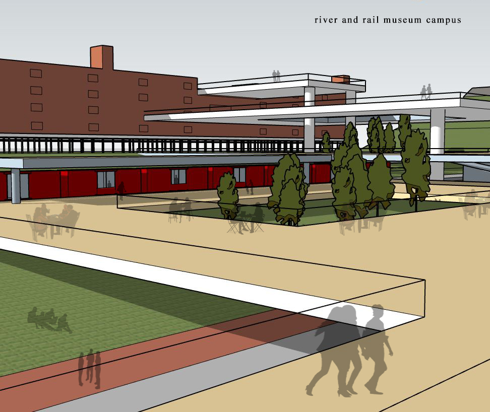
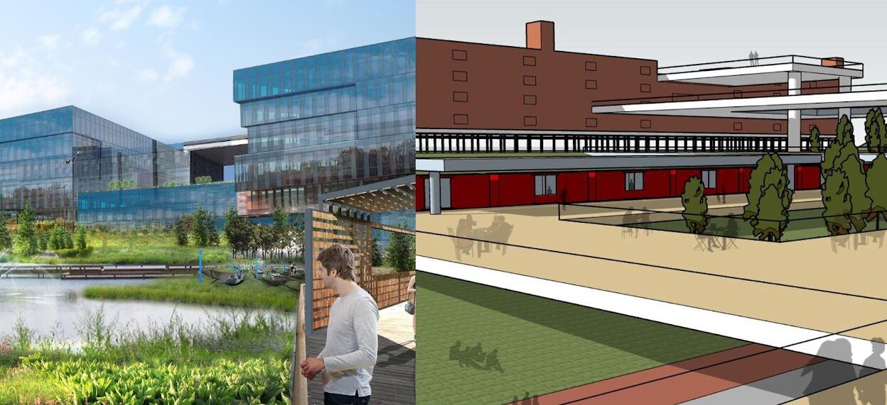
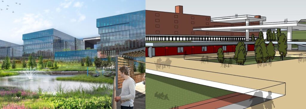
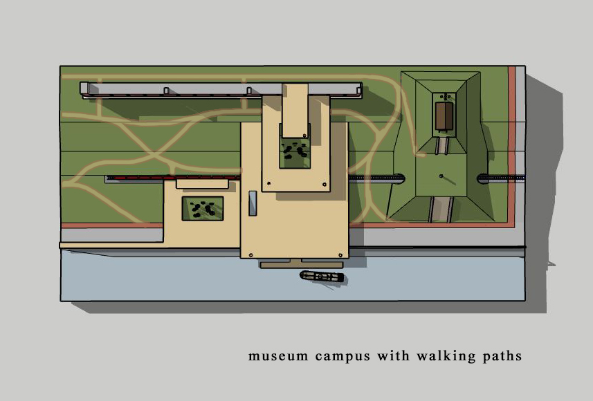
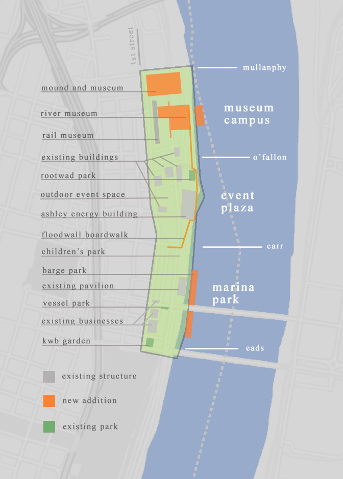
Reimagining GRG’s Innovation District as a Museum Campus
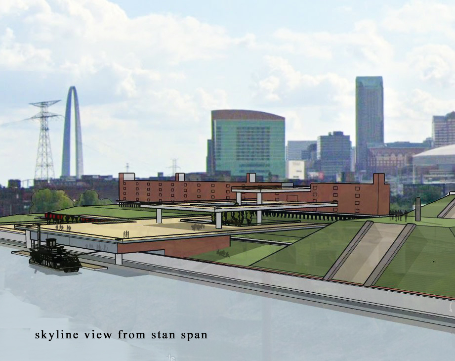
Instead of an office park, what if the Cotton Belt Depot and the adjoining areas were a museum campus that interpreted the riverfront’s history as a “river and rail” industrial hub, in addition to paying tribute to the pre-Columbian history of the site with a large Mississippian mound.
The museum could incorporate structures to reinstate access and views to the river beyond the flood wall. It could orient the rail spur that currently exists here to provide exhibits for the museum and rail cars could be converted to kitchens for an open air cafeteria.
At the northern edge, a mound could separate the site from current industrial use just to the north, while creating more river views and avoiding blocking the view of the “stan span”. A river museum located under a large viewing platform that stretches out over the flood wall could allow up close views of the river, and access to the riverfront where floating river exhibits could be located. These spaces could connect to a boardwalk that runs along the flood wall back to the open riverfront to the south, while avoiding obstructing the Riverfront Trail. Open spaces on the platforms and lawn could incorporate tree canopy with sculptural industrial objects in keeping with the historical and industrial theme of the campus.
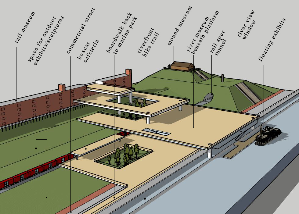
While it is true that similar institutions already exist in the Greater St. Louis area, including the National Transportation Museum, the Cahokia Mound State Historic Site, and the Missouri History Museum, a site on the riverfront could serve as a nexus of these cherished institutions, bringing together their collective knowledge into the context of a symbolic and literal post-industrial landscape. It could likewise serve future industrial innovation by maintaining a lab and related programming.
Additionally, an updated plan could reorient thinking about the spaces east of 1st street separately from the possible residential and office uses to the west, if only to ensure we don’t lose sight of park opportunities, waiting for residential/office development to happen.
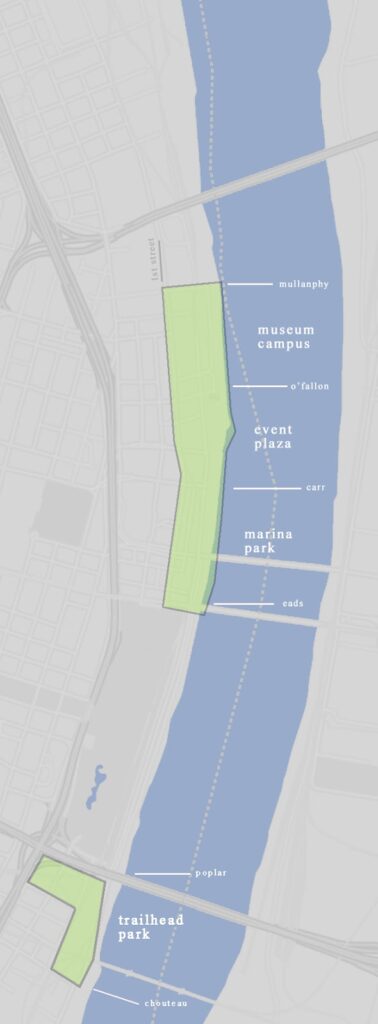
South of the museum campus, in the Creative District, would be the event plaza. The uses in this area would remain similar to those outlined in the plan. The Ashley energy building forces the orientation here back inward, and as the plan suggests this building creates a cool backdrop for concerts and festivals, Additionally, the several other historical structures here divide this area and the adjoining museum campus creating a “natural” barrier. These large structures could house many other large and small scale events.
South of the event plaza, in the Lumiere and Laclede’s Landing districts would be the marina park. Again little about the plan would change here except pushing residential and office development back beyond 1st Street unless it already exists in this footprint.
While technically it would be considered the south riverfront, I would add one more element to this plan, which would be creating a trailhead park in the unoccupied space directly south of the arch grounds where the bike lanes which cross north through the arch grounds and NRF begin, and consider connecting bike paths along the rail corridor back to Brickline additions.
We think of ourselves as a great river city, and yet our public spaces and institutions along the river itself are few and far between. As our reliance on the river has dwindled, so has the riverfront. Because the river has historically created opportunities for industry, the riverfront itself has become an industrial ruin. It is up to us to acknowledge, understand, and interpret this important history, not simply repeat it.
