Over the last month, five people have been hit and killed while walking on St. Louis streets. Two hit and run fatalities along Grand Ave (one on S. Grand, and another on N. Grand), a fatality along Hall Street, another on Martin Luther King, and the fatality of a 17-year old on Chippewa. These tragedies have sparked conversation from residents, business districts, neighborhood associations, advocacy groups, and others – all focused on the same question: How can our elected officials and city government address this continuing plague of traffic violence?
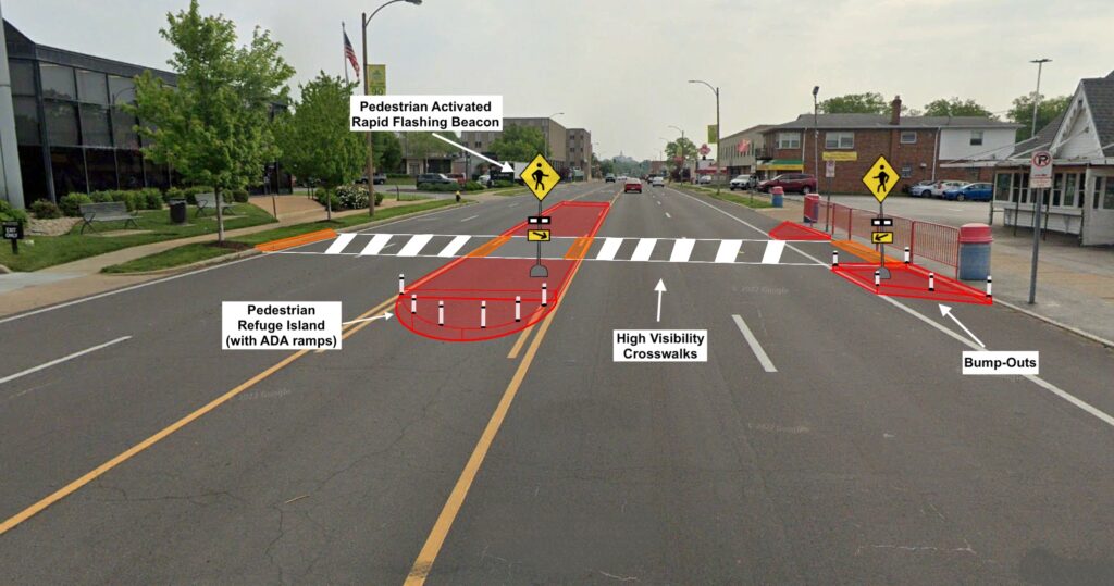
In the wake of the crash on Chippewa, Trailnet proposed enhanced pedestrian safety measures in front of Ted Drewes which will hopefully be installed within six months. The current plan is to install a median (most likely in the form of a pedestrian refuge island) with new crosswalks in front of the St. Louis landmark. While this type of single solution infrastructure may help reduce crashes at this singular location, the City still lacks a comprehensive, City-wide approach to addressing traffic violence. We need a systematic approach to stopping crashes and fatalities before they happen and creating a network and culture of people-friendly streets that welcome people to walk, bike, and use public transit.
Addressing the issue of traffic violence is extremely complex as there are many factors that affect different types of crashes. It would be nearly impossible to outline every solution to addressing traffic violence. This article, and subsequent articles in the “Moving Forward” series, will emphasize several solutions local, state, and federal governments can implement. This article will focus on “Redesigning Our City ”, which will assess how transportation infrastructure and urban design can decrease traffic violence in the St. Louis region. The next piece will cover “Personal Accountability”, which will cover drivers education, traffic enforcement, and legal actions of negligent driving. The last piece will cover “Systematic Solutions”, which will dive deeper into regional approaches to traffic violence and other preventative measures.
The Data
The first step to improving safety for people walking is looking at the data. By looking at location, type of street, speed limit, and other factors of fatal pedestrian crashes for 2022, the similarities paint an obvious picture. It is evident the most dangerous streets for people walking in St. Louis are wide, high speed, arterial streets. Of 12 total pedestrian fatalities so far in 2022, 11 fatalities have occurred on arterials.
| Crash | Street | Type of Street | Speed Limit | Number of Lanes | Total Lane Width |
| 1 | Chippewa | Arterial | 30 MPH | 3 lanes | 30 ft |
| 2 | Goodfellow | Arterial | 30 MPH | 2 lanes | 20 ft |
| 3 | Washington | Arterial | 25 MPH | 5 lanes | 50 ft |
| 4 | Walton | Local | 25 MPH | 2 lanes | 20 ft |
| 5 | Tucker | Arterial | 35 MPH | 6 lanes | 70 ft |
| 6 | Broadway | Arterial | 35 MPH | 3 lanes | 50 ft |
| 7 | Chippewa | Arterial | 30 MPH | 5 lanes | 56 ft |
| 8 | Grand | Arterial | 25 MPH | 3 lanes | 50 ft |
| 9 | Grand | Arterial | 35 MPH | 4 lanes | 50 ft |
| 10 | Chippewa | Arterial | 30 MPH | 5 lanes | 56 ft |
| 11 | Hall | Arterial | 45 MPH | 5 lanes | 60 ft |
| 12 | MLK | Arterial | 30 MPH | 3 lanes | 50 ft |
Historic crash data also supports that high speed, multi-lane, arterials are where a majority of pedestrian crashes occur. The data also support streets like Grand, Chippewa, Kingshighway, Broadway, Natural Bridge, and others continue to be an issue for the City year after year.
- In 2020 & 2021, 69% of pedestrian fatalities (27/39) and 63% (294/464) of total pedestrian crashes occurred on arterial streets.
- In 2020 & 2021, 1 out of every 5 pedestrian crashes occurred on either Grand, Kingshighway, or Natural Bridge. Those 3 streets account for 0.5% of St. Louis lane miles.
- Since 2017, 9 streets (Broadway, Grand, Kingshighway, Chippewa, Union, Natural Bridge, MLK, Lindell, and Gravois) have accounted for 40% of total pedestrian crashes and 46% of pedestrian fatalities, yet only accounting for 1.5% of St. Louis’ total lane miles.
The crash trends on arterials is not only specific to St. Louis. Smart Growth America and the National Association of Transportation Officials (NACTO) have reported that nationwide “60 percent of all 2020 deaths occurred on non-interstate arterial highways” and in urban areas “that number grows to between 64 and 67 percent, even though this type of road only makes up 15 percent of all roads”.
Redesigning Our City
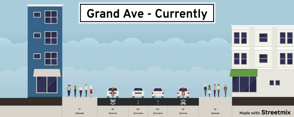
It is no mystery that cities throughout the United States, especially St. Louis, have been redesigned and developed for automobiles. The advent of the motor vehicle and interstate highway system has largely changed how our cities look and function. St. Louis infrastructure was planned and built for over a million people, but steady population loss over decades has changed St. Louis into a vastly overbuilt landscape with a wide and often underutilized street network. These wide streets are partially at fault for the rise in traffic violence we’ve seen in the City of St. Louis. Multi-lane (3 – 5 lane) arterial streets encourage people to drive at fast speeds, easily at 5 to 10 MPH above the posted speed limit.
It will take years to reverse this pattern on all of our streets, but on some high crash corridors (Grand, Kingshighway, etc) we can make major improvements to redesign those streets into corridors that 1) prioritize people who walk, bike, and use public transit (“Streets for People”), and 2) encourage safer driving conditions (“Traffic Calmed Streets”).
| “Streets for People” | “Traffic Calming Streets” |
| Everyday destinations along the street(grocery stores, dining, healthcare, etc) | Overbuilt streets with low traffic volumes |
| High counts of people walking and biking | Streets with adjacent land uses with low turning/traffic movements |
| Several MetroBus and MetroLink connections | Streets with long, uninterrupted stretches, not a lot of traffic lights and stop signs to impede speeding traffic |
| Streets along High Density areas | Low volume or lack of bus service |
| Examples: Manchester, Grand, Kingshighway | Low walking/biking traffic |
| Examples: Broadway, Germania, Hall |
Streets for People
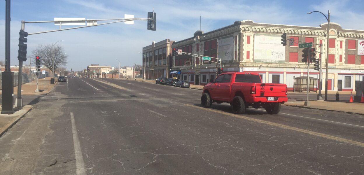
St. Louis has several areas that attract people to dine, play, and spend time. However, a lot of those areas aren’t comfortable and inviting to walk, bike, or take public transit to because they are often dominated by wide travel lanes and excessive on-street parking. Streets like Grand, Gravois, Kingshighway, and Manchester all have numerous high profile St. Louis destinations along them, yet year after year are some of the most dangerous places for people to walk and bike. It is time to start designing these streets for people and not for cars to speed through.
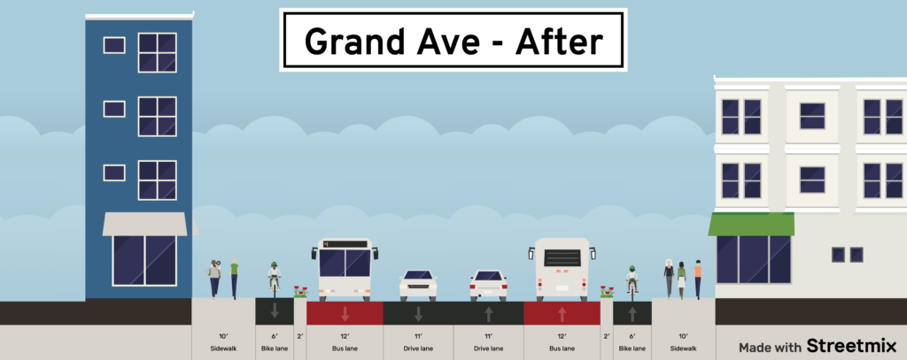
Reducing and reusing existing travel & parking lanes for other non-vehicular travel modes is a universal solution to prioritizing St. Louis streets that move people who walk, bike, and take public transit. By repurposing underutilized travel & parking lanes into Bus Rapid Transit lanes, protected bike lanes, and wider sidewalks would create streets that encourage people to walk, bike, and use public transit instead of driving. NextSTL contributor Tony Nipert wrote an article about “Considering BRT on Kingshighway”, a completely plausible solution that could be applied to high-use MetroBus routes on streets like Grand, S Broadway, and Chippewa.
The possibilities to redesign and reprioritize Grand Avenue are limitless. Grand is arguably St. Louis’ most important street. Along Grand there are:
- 3 major business/shopping/entertainment districts
- St. Louis University
- Fairground, Tower Grove, and Carondelet Park
- Red and Blue Line MetroLink connection
- The 70 Grand – the region’s highest ridership MetroBus route
- A major medical center
Currently, Grand is known as a place with one of the most dangerous intersections in America and a place where people are now afraid to walk and bike near because they are afraid they could lose their life from a speeding car. Grand is long overdue for a redesign. Removing travel and parking lanes in some areas and reusing those spaces for MetroBus lanes, wide sidewalks, and protected bike facilities would drastically transform Grand into a corridor that’s safe and inviting for everybody. By designing streets that are safe and inviting for people, there’s also vast potential to drive economic growth, attract new businesses, and create thriving business districts.
While many of these corridors are in desperate need of upgrade, several of the corridors where pedestrian fatalities have occurred do have future plans to implement bike and pedestrian enhancements. Tucker Blvd and S. Broadway have funding allocated to build protected cycle tracks, both planned for construction in 2023.
Traffic Calmed Streets
There is also great design potential to change St. Louis high crash corridors through enhanced traffic calming infrastructure. These streets, compared to the suggestions made in the “Streets for People” section, would be more focused on creating calm streets that encourage cars to slow down. These are streets that maybe have less bus traffic, fewer pedestrian destinations, and fewer pedestrian crashes, but are still high crash corridors for other modes. Examples of streets that could use major traffic calming improvements include N. Broadway, Hall, Germania, N. Florissant, and Martin Luther King Blvd.
The main example of this type of enhancement we have in the City of St. Louis is Natural Bridge Ave. Prior to the project, Natural Bridge was one of the most deadly corridors for people walking, biking, and driving. Since improvements were made in late 2020, total crashes (across all modes) decreased by 45%, and crashes resulting in a personal injury or fatality reduced by 65% along the corridor. The reduction in crashes should be viewed as a massive success for the region, and the City of St. Louis and other stakeholders should look to implement similar projects on the streets mentioned above.
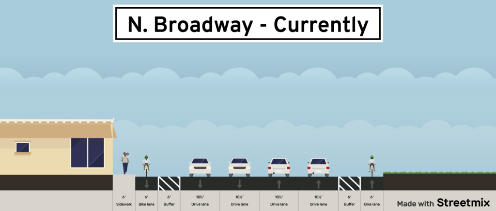
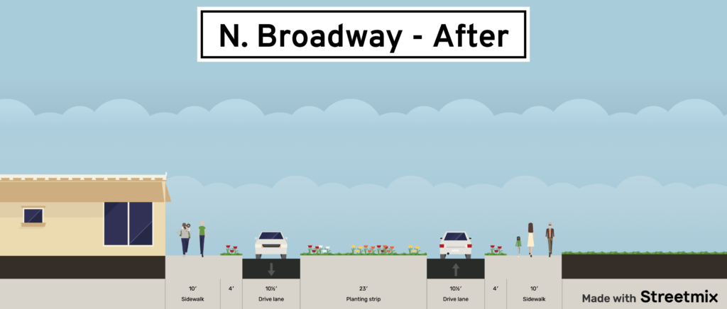
Wide arterials with low turning traffic (onto side streets) are optimal candidates for this type of infrastructure improvements. For example, N. Broadway (Carrie Ave to Switzer Ave) is a long 1.5 mile stretch, which consists of 4 travel lanes and a buffered bike lane. This section of Broadway is a racetrack, where I’ve often seen drivers pass other drivers by using the bike lanes and even the opposite travel lane. With the low daily traffic counts and the lack of turning movements to adjacent streets (2 entrances to Bellefontaine Cemetery on the west and heavy industrial usage on the east), a reduction of lanes along Broadway is warranted. By narrowing the lanes to as small as possible (often 10 – 10.5ft) and filling in the remaining space with new sidewalks, medians (with enhanced crossings), and landscaping this section of Broadway has the potential to transform into a calm street.
Hall Street, Germania Ave, and countless other streets across St. Louis share similarities with N. Broadway. Streets with 4+ total lanes and adjacent land uses that are not high traffic streets should be immediately considered for traffic calming improvements, regardless of their crash history. For context, there’s only been one traffic fatality along Germania since 2018, but due the streets wide lanes and lack of signalized intersection make it conducive for speeding and the potential for a fatal crash is high. This type of proactive and preventative analysis is needed on every single St. Louis street. By accounting for characteristics like road width, number of lanes, adjacent land uses, underutilized bike infrastructure, and other factors we can accurately design and construct streets that meet the travel demand and create safe driving conditions.
As of August 28th, 12 people have been killed while walking in St. Louis. This is one more fatality than at this time in 2021. If this trend continues across the City, there is a possibility for pedestrian fatalities to increase in the City of St. Louis for the 5th year in a row. It does not have to be this way. St. Louis streets are well past due for a redesign.
These dangerous, arterial streets are often the connection to grocery stores, schools, libraries, parks, restaurants, and other basic amenities. When poorly designed, these streets dissect our neighborhoods, making basic connections to important destinations, a life or death task. There is great potential to make safety improvements for people who walk, bike, drive, and take public transit. Now is the time to make our streets safe, comfortable, and inviting for all. Now is the time to make our streets about people, not cars.
Footnote: This article is Part 1 of a series that looks at improving traffic safety and reducing traffic violence in the City of St. Louis. Part 2: “Personal Accountability” will be released in early September and Part 3: “A Systemic Approach” will be released in Mid-September.
