A major overhaul of one of St. Louis’s high-crash roads cut the number of deadly crashes, improved pedestrian safety, but still has a long way to go. A year-long overhaul of Natural Bridge Avenue in St. Louis City has led to a 65% decrease in injuries and deaths but raises other questions about road safety across the city and region.
According to Trailnet’s 2021 Crash Report, Natural Bridge and a handful of other streets in St. Louis are responsible for a disproportionate number of crashes involving people who walk, bike, and drive. Since 2017, nine roads (Broadway/7th, Chippewa, MLK Drive, Gravois, Grand, Kingshighway, Lindell, Union, and Natural Bridge) are responsible for 40% of all pedestrian crashes and 46% of all pedestrian articles.
Background
If you have walked or biked near Fairground Park, taken the 4-Natural Bridge MetroBus, or driven down Natural Bridge recently, you’ve probably noticed something different about Natural Bridge. The conversation about modifying Natural Bridge began back in 2017 when the Missouri Department of Transportation (MODOT) and local city leaders conducted a safety audit of the thoroughfare. In the audit they found two big takeaways 1) Natural Bridge had “a crash rate higher than the state average for similarly traveled roadways, with some sections of the road being significantly higher”1 and 2) crashes were caused by several factors including excessive speeding and drivers changing lanes improperly.
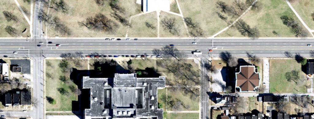
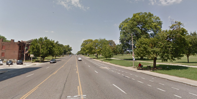
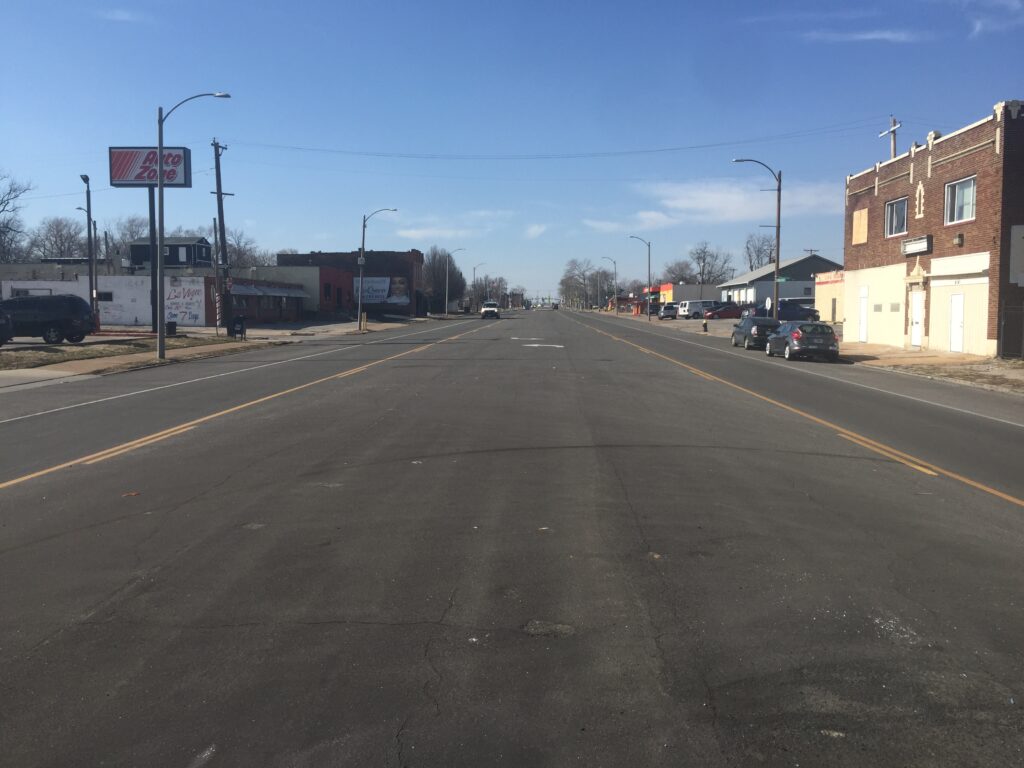
The expansive design and width of Natural Bridge backed up these takeaways. Before construction in summer 2020, Natural Bridge was a sea of asphalt, a majority of which was dedicated to the movement and parking of cars. Near Fairground Park, Natural Bridge reached up to 85 feet wide, which for comparison, the three-lane sections of Interstate 70 and 64 are around 72 feet wide (36 ft in each direction). Drastic roadway changes needed to be made to cut down on high injury crashes.
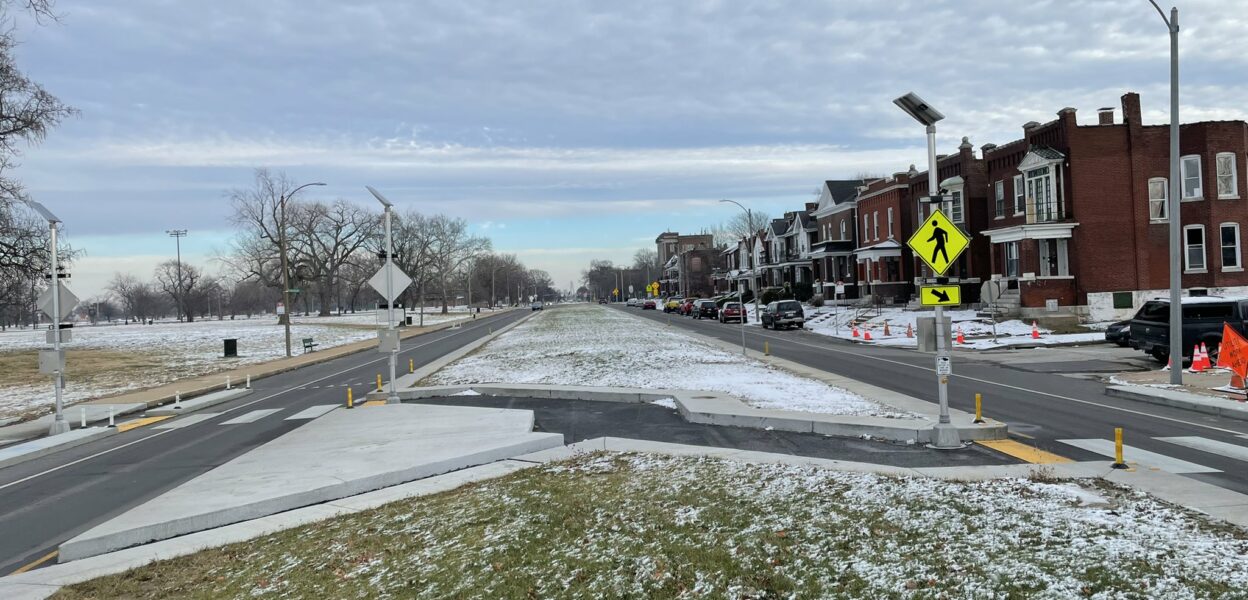
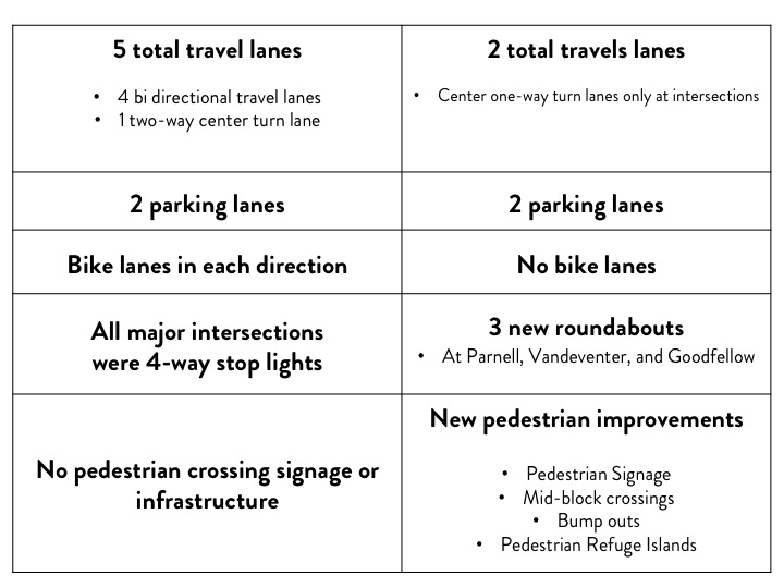
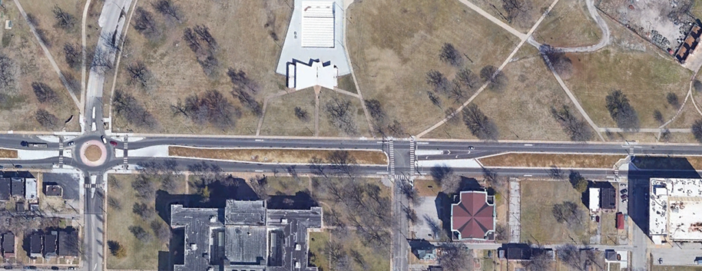
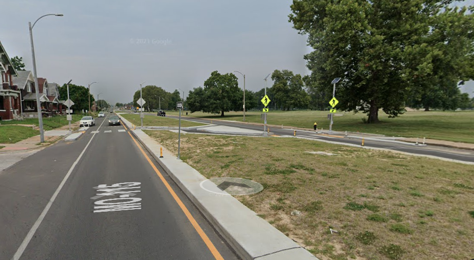
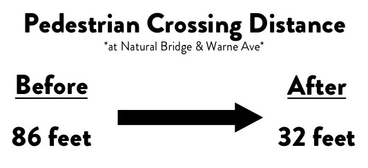
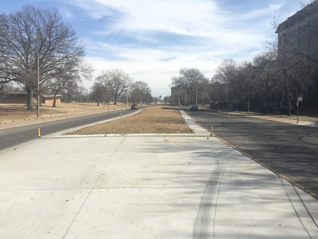
Since construction was completed in November 2020, Natural Bridge looks completely different. Specifically from Marcus Ave to Parnell St, Natural Bridge now only has 1 travel lane in each direction with dedicated turning lanes at intersections. The width of the road remains the same, but the space allocated for cars has been cut in half (approx. 44 ft for travel and parking lanes). A majority of that space has been taken up by long concrete medians occupying the space where the center turn lanes used to be. The project also converted 4-way intersections at Parnell, Vandeventer, and Goodfellow into roundabouts, added mid-block pedestrian crossings with refuge islands, and concrete bump-outs to create a shorter crossing distance.
Data
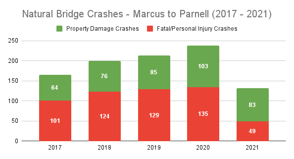
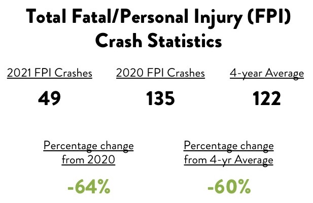
Because of this project’s magnitude and previous high crash statistics, I thought it would be interesting to analyze the number of crashes along Natural Bridge, specifically where MODOT made the improvements (Marcus to Parnell, and at the Goodfellow intersection). Below are several fascinating figures regarding crash rates along Natural Bridge since 2017. If you are interested in learning more about my methodology it is at the bottom of the article.
Room for Improvement
It should be noted that even though crash rates did drop from 2020 to 2021, there are still aspects of the Natural Bridge project that fall short of a success in my opinion. In some places, the center turn lanes are extremely wide, specifically by the Advanced Auto Parts where the center turn lane is approximately 33 feet wide. Compared to the average width of the center two-way turn lane, which is typically 10 – 14 feet wide, this turn lane can cause turning confusion and is just generally unnecessary.
While the concrete median helps reduce speeding by narrowing the travel lanes and space dedicated for cars, many residents I’ve spoken to feel that the large concrete medians and scarce grass are a letdown. Looking down Natural Bridge, the medians are desolate and harsh to the eye. Several rows of colorful plants or even trees would brighten up the section of the roadway. Planting trees and other landscaping would provide greater shade which in turn could encourage more people to walk and could force cars to slow down even more2.
Even with the significant decrease in the total number of crashes in 2021, there were still some conditions where crashes increased. In 2021, at the intersections of Natural Bridge/Vandeventer and Natural Bridge/Parnell, the total number of crashes increased from 2020 and were higher than the 4-year average. These two intersections were two of the three intersections (along with Natural Bridge/Goodfellow) that transitioned from a 4-way intersection to a roundabout. I don’t think this increase is particularly surprising. This Natural Bridge project is really the first large corridor reconstruction project in the City of St. Louis since the South Grand Road Diet project in 2015 and the Forest Park Parkway reconstruction in 2017. The transformative roadway changes, especially with the roundabouts, will take more than a year for people driving to get used to. Coupled with the fact that Missouri does not require driver’s education to obtain a driver’s license only piles on to potential driving issues. Drivers education is where people would get an education and real-life experience on how to properly navigate through a roundabout.
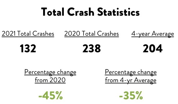
I’m not the only person to admit that the Natural Bridge project isn’t perfect. However, the decreases in crash numbers especially crashes resulting in a personal injury or fatality exhibit how the project is meeting its goal to reduce crashes along the corridor. If the crash trends continue to decrease year after year, our elected officials and governmental staff should look to implement projects similar in design on roads like Grand, Union, Broadway, Kingshighway, and other high crash corridors across the City of St. Louis.
Methodology
For all crash analyses, I pull vehicular, pedestrian, and bicycle crash data from the Missouri Statewide Traffic Accident Records System (STARS), which is managed by the Missouri State Highway Patrol. This data source allows people to see when and where different types of crashes occurred as well as particular crash characteristics. It should be noted that all of the numbers and percentages you see in the article are the number of people affected by a crash, not the number of crashes that were reported.
All of the data for this article was compiled during a specific time frame. Because the Natural Bridge project was finished in November of 2020 I only looked at crash data from the beginning of each year to October 31st of each respective year. Comparing crash statistics from the entire year would be somewhat misleading since Natural Bridge looked entirely different for the last two months of 2020.
