A couple comments to Mark Groth’s Heal the Grid a Forest Park Southeast Success Story suggested that St. Louis’s street blockages enhanced walkanility. Let’s take a deep dive.
#Healthegrid isn’t just about the blockages
While street blockages are the most prevalent, the grid has been injured in other ways. By highways, superblocks, and parking. Like the superblock for the Millennium hotel complex downtown which keeps Clark St from reaching Memorial or the convention center now expanding further severing the neighborhood to the north from downtown. There’s the SLU High, Science Center, SLCC swath of interruptions of Berthold Ave. A few blocks of The Hill are severed from the rest by I-44. The highways did some of the worst damage, severing places like McRee Town from Shaw and Benton Park and Soulard. Now we see them as separate places when before they were knitted together by many walkable connections.
Those make you go way out of your way no matter whether you’re in a car or not. These are especially detrimental to walkability and bikeablility due to the extra time it takes to go around and often force use of a stroad which are all that worse since car traffic is funneled onto them and kept on them longer than otherwise necessary by the injuries to the grid. The exacerbated flooding of the stroads also is a determent to transit as waiting for a bus is rendered more miserable by the extra traffic, and the bus gets impeded more often by the traffic. Then there’s a few blockages that not only block vehicles in the street, but the sidewalks too. Clara at Delmar was that way until recently (see Exclusion City: #Healthegrid).
Then there are injuries that encourage driving. A five point interchange was a great opportunity to make a place for people, but no, the priority was to move more vehicles quickly on Union and Page and provide parking. We’ve seen the intersection further deteriorate as human-scaled buildings were lost reducing friction encouraging dangerous driving.
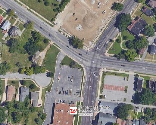
An epitome blockage
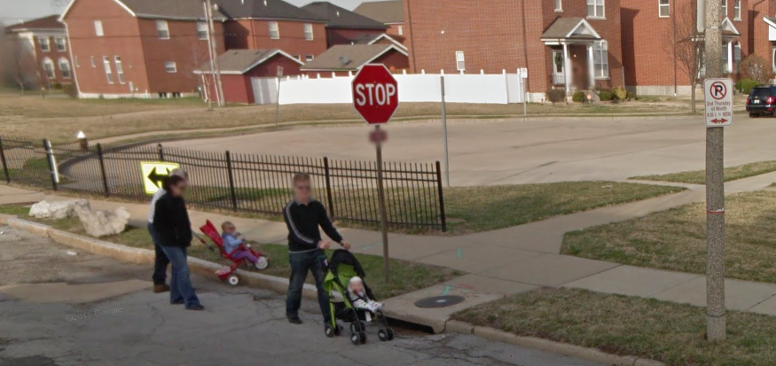
I added this image from Google Streetview to Mark’s article. I used it in my Cost of a Cul-de-sac article. Check it out for a rundown on how the land productivity forgone for the cul-de-sac was ill-advised. In terms of walkability the takeaway is that with all the spending and assumed liability for the pavement and fencing, they failed to put the littlest things for walkability- a curb cut for those folks to take their stroller up to the sidewalk and a marked crosswalk. Nor is there a pavement-level opening for cyclists. Also the three potential houses (or a corner business) foregone for the cul-de-sac means three households located somewhere else, further spreading out the city. Things further away are a determent to walkability.
A commenter’s point about the photo was, see people are walking, the blockage helped walkability. They missed that they were in the street exposed to traffic without a marked crosswalk, putting up with the lack of a curb cut. It seemed to me walkability and connecting the part of the neighborhood behind the fence to the part to the west was not top of mind when designing this infrastructure, rather it was to separate places, not transportation modes.
Impact on on conflict points
A commenter claimed the blockage enhances walkability by removing a person-vehicle conflict point. Fair point. At this blockage vehicles cannot pass so a conflict point is eliminated. This intersection doesn’t operate in a vacuum though. Let’s zoom out.
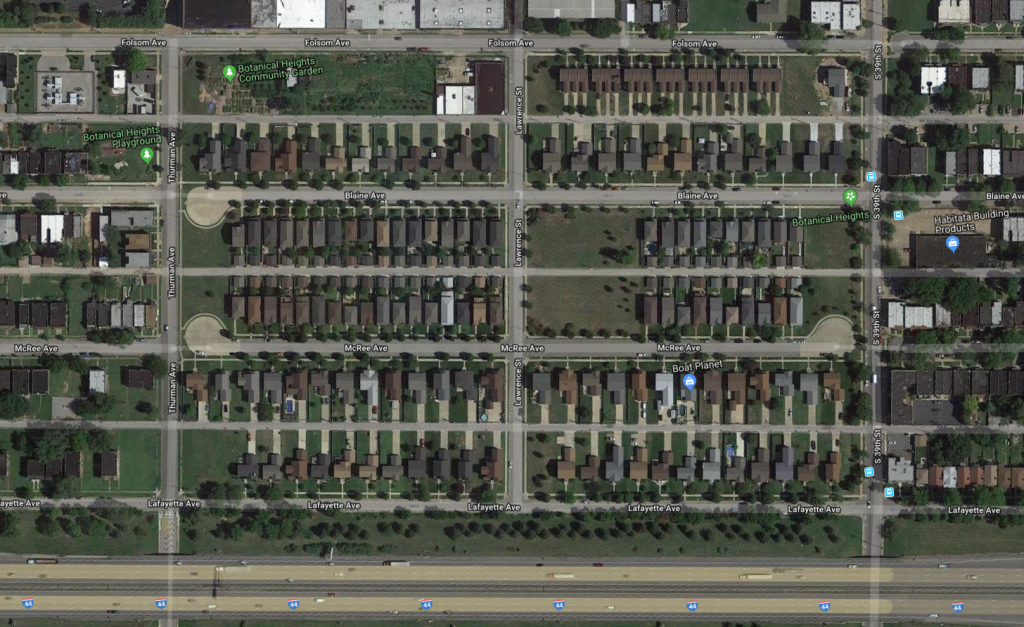
While the west end of the block has zero person-vehicle conflicts, since any trip originating or ending on that block can only enter via the other end of the block, conflicts at the east end are doubled.
Let’s consider some trips to the 4000 block of McRee.

A local trip from the southwest has five conflict points.
Oopsies, Lafayette is one-way westbound. Due to the highway’s damage to the city, Lafayette serves as a frontage road with a > 20 foot luxury lane to encourage high speeds. Let’s count again.
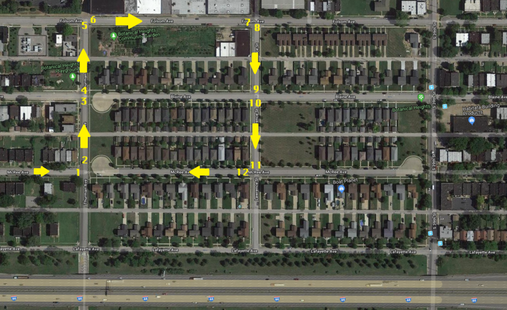
Twelve conflict points
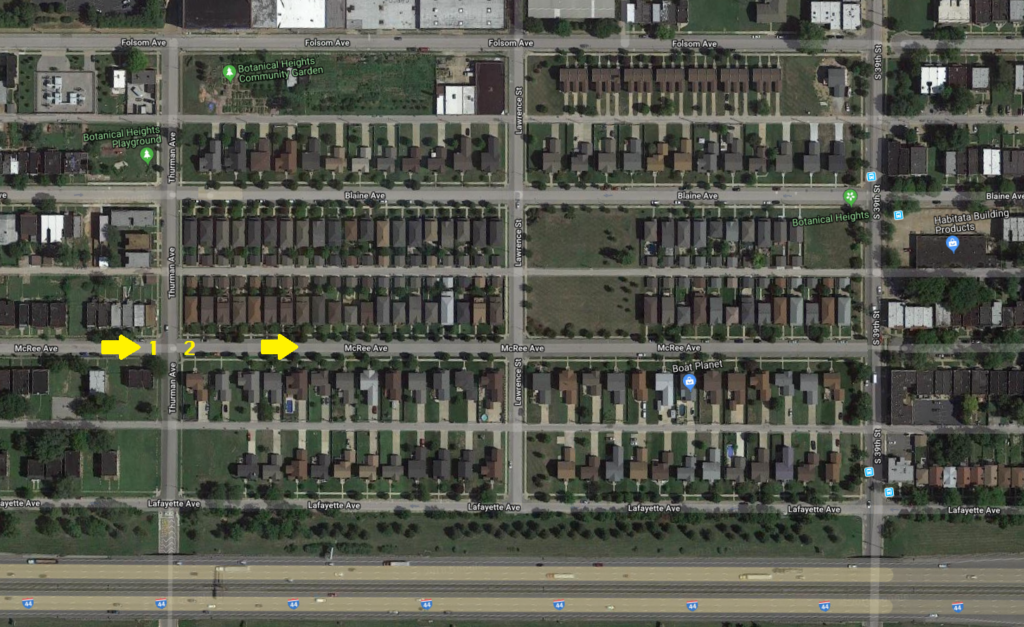
A trip without the blockage has two conflict points. A net increase of ten.
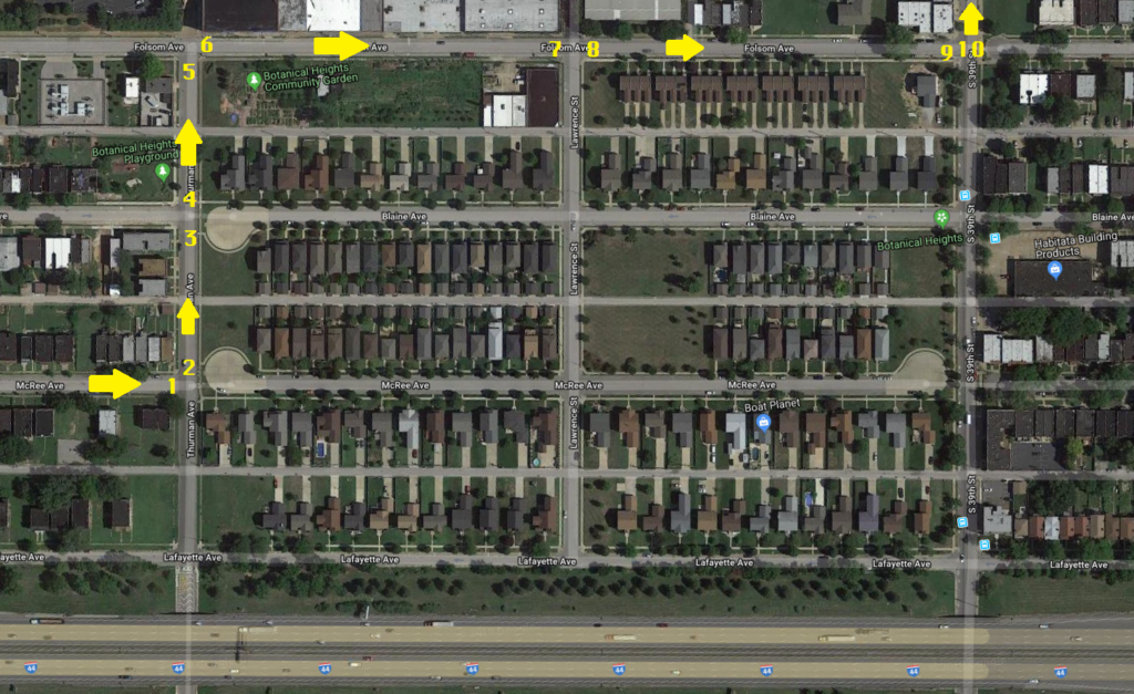
A trip from the northwest has two more conflict points due to the blockage. Encouraging the use of Folsom is not great considering there’s a school on the north side.
For local trips, the blockage has added to the number of conflicts and shifted them to other blocks. You’ll see shifting negative externalities from driving elsewhere is a common outcome (feature?) of street blockages. Too bad for the folks on Folsom.
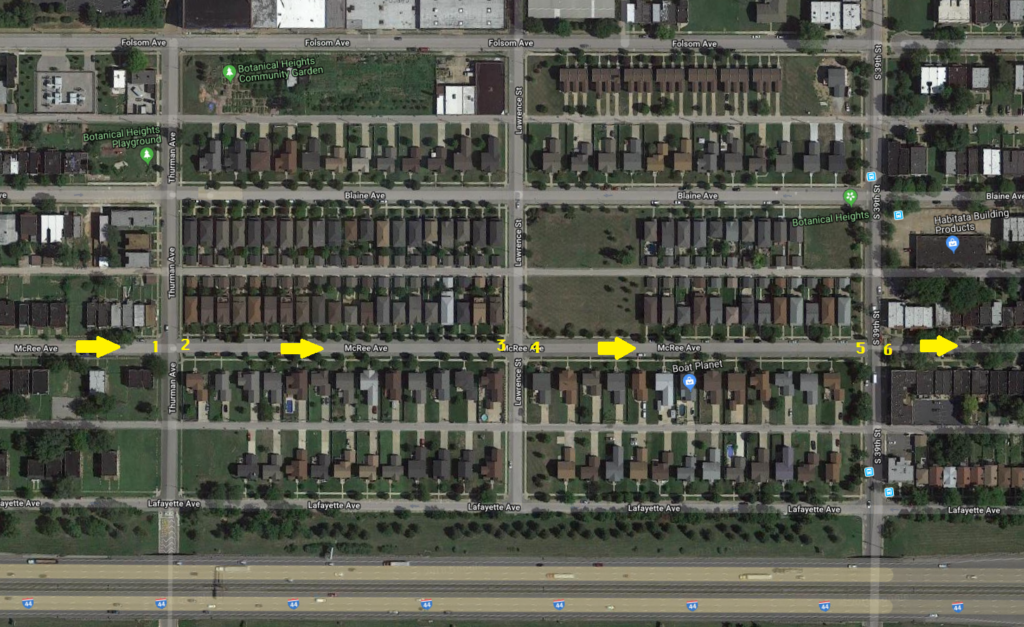
Through trips are eliminated so person-vehicle conflicts from that type of trip are eliminated at both ends of the block. Let’s count the conflict points for a trip starting on the 4100 block of McRee towards the northeast to get some Cap’n D’s.
There are ten conflict points. Without the blockage there are also ten conflict points a wash, but the blockage shifts them. Too bad for the folks on Folsom. Suck it up!
Let’s get some Starbucks at their convenient drive-thru at Grand and Sidney. The circuitous route you have to take- Thurman, Folsom, 39th, Park, Spring Park, Grand is 16 conflict points versus 9 for am open McRee. Or you could head west and double-back via I-44, or take the alley between McRee and Lafayette to take 39th south. Shifting, adding conflicts, adding left turns lengthening trips.
Noteworthy is that not all conflict points see the same amount of pedestrian traffic, to be fair.
In these cases the blockage added or shifted traffic to the 4100 block of Folsom. Instead of speeding down McRee, drivers can speed down Folsom. Too bad for the folks on Folsom. Again shifting the negative externalities from driving elsewhere. It’s a Prisoner’s Dilemma game. There is temptation to block a street for those on the street when it would be better overall not to block any, at least in terms of minimizing conflict points (or VMT as I’ll get into next).
Also noteworthy is that the cul-de-sacs (by occupying space that could have had buildings close to the street) remove friction for northbound drivers on Thurman rendering a higher rate of speed more comfortable.
Impact on Vehicle Miles Travelled (VMT)
The blockage adds to vehicle miles travelled to trips. At least 2,000 feet in the case of the local trip from the southwest. This adds to all the negatives of VMT- more noise, air pollution, particulates, crashes, fuel expenses, vehicle maintenance and depreciation, etc. And the extra length is on other blocks, again shifting negative externalities elsewhere. If a driver misses their sometimes only way to access where they’re going, it would add even more VMT.
Impact on number of car trips
Does the blockage discourage car trips by making driving more cumbersome? That could make up for the additional conflict points and VMT. For local trips to/from the west of the block, it adds 2,000 feet or 350 feet depending on the direction. Is that enough to elicit a mode switch? Certainly not if those distances are a small fraction of the trip. For very short trips? Maybe, though by removing friction on Thurman trips to the west by bike or foot are more tenuous. And for anyone to the west thinking of going to points east on foot or wheel, the blockage and fence say this is a different place, not for you.
I could see it for the trip to Starbucks. The thing is you have to deal with Grand stroad, and the Starbucks is auto-oriented (certainly not the worst granted). Points further south on Grand? The frequency of the Grand bus helps the calculus. Opt for a café closer reached via foot or bike? Now we’re talking.
Traffic calming backfire
The extra unexpected distance and confusion due to the blockages may contribute to road rage and speeding.
Follow through on the other things that enhance walkability and bikeability
If we want to enhance walkability, bikeability, and transit utility in our city, we have to do all the things. Lots of blockages enacted in an ad hoc un-coordinated way is far from adequate as we know from our everyday experiences. Even where there are blockages, our streets still say “this is for vehicles.” We need streets that say “vehicles tread lightly.” We need traffic calming techniques of all sorts. Narrower lanes. Traffic circles. Raised crosswalks. Raised intersections. Mid-block crosswalks. Curb bump outs. Shared spaces. Fewer lanes. Less parking and less subsidized parking at destinations. Transit priority. Bus lanes. Higher transit frequency. And the most fundamental- things closer together so trips by foot, bike, or transit are practical. In other words, don’t waste land on a gas station at Grand and Lafayette. Instead put multiple things so neighbors in Tiffany and Botanical Heights have places they can walk and bike to to accomplishes some of life’s tasks. Fewer trips by car and fewer miles driven makes a city better for everyone, including those driving.
StlToday – Pedestrian killed in hit-and-run crash in St. Louis, police say
Not Just Bikes shows us walkable and bikeable places and how they work. Check out these videos, especially the one on how driving is great.
