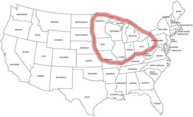

In a large way, our perception of place is set in opposition to other places. In this case, the Midwest ends in my mind where some other place begins. Centered more or less on my home state of Indiana, the Midwest ends at the Great Plains, the South, the Appalachians (more or less) and Canada. It would seem the most significant difference between this and what many people are drawing as part of the interactive survey My Midwest is that they don’t seem to recognize the Great Plains as a distinct region.
The map offered by respondents varies according to how much time individuals have spent in the Midwest. Basically, the more time one has spent in the region, the more defined the Midwest appears. The region is less likely to reach up to Idaho or include Denver, it appears. So where is the Midwest to you? Feel free to download the blank map below and add your idea of the Midwest in the comments.

The Atlantic Cities recently had a write up on the mapping survey. The Boston Society of Architects is presenting an exhibit titled Reinvention in the Urban Midwest curated by Sasaki Associates, a Boston area architecture and design firm. A number of Washington University educated architects have held leadership positions at the firm over time and Sasaki recently produced a visioning plan for Clayton, MO, a prosperous inner-ring St. Louis suburb. The interactive survey is meant to help understand just where people imagine the boundaries of the Midwest are drawn.
From the Reinvention of the Urban Midwest:
Last year, one in 10 people who moved to Massachusetts were from the Midwest. These more than 12,000 arrivals are enough to populate Boston’s Beacon Hill; yet, to many New Englanders, the Midwest is an indeterminate place somewhere between here and California. What is the Midwest, really, and why does it matter here in the land of the Pilgrims, Fenway Park, and triple-deckers?
The upcoming exhibition Reinvention in the Urban Midwest, curated by Sasaki Associates, will focus on current forms of reinvention in the urban Midwest and explore the drivers for such a recurrent phenomenon: global competition, cultural shifts, dwindling resources, and the acute need for greater resilience.
In addition, the exhibition will investigate what the Midwest really means outside its topographical boundaries and why that should matter to us. MyMidwest, an interactive, map-based survey through which visitors can share what they consider to be the physical boundaries of the Midwest, will gather the collective consciousness associated with the Midwest in New England. This tool is available online for those wanting to play now!
A selection of Sasaki’s vast work in the Midwest will be on display, including the Chicago Riverwalk; Midtown Detroit TechTown District Plan; The Tomorrow Plan in Des Moines, Iowa; University of Nebraska–Lincoln Masterplan in Lincoln, Nebraska; and The Ohio State University Park–Stradley Hall in Columbus, Ohio.

__________________
More maps 07/21/13
The discussion here, on Twitter and with other over the past view days has been interesting. There’s still no right or wrong answer, but a variety of plausible definitions have been presented. There are surely many more, but here are a few more:
For some, including myself, the Midwest is somewhat synonymous with the Big Ten athletic conference (shown below in orange). Adding Penn State in the 1993 pushed the confernce into central Pennsylvania and now Nebraska is in, with the states of Maryland and New Jersey coming soon:

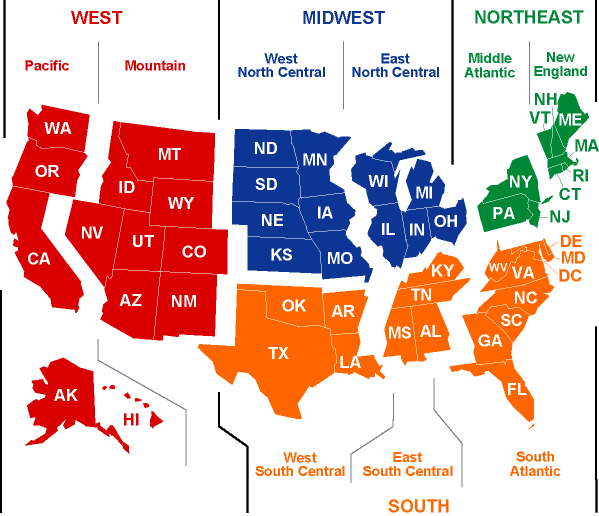
A number of maps split the states into just four regions and then subdivides those. Here, the Midwest is split into east and west, basically following the Mississippi River:
Others use nine regions and do not use “Midwest” at all:

Time zones help divide regions for some. Until 2006, Indiana spent half of each year in the Eastern and Central Time Zones. The metro regions around Chicago and Evansville remain on central time:
The major river systems of the nation tie together large portions of the middle states and help define the Midwest. The Ohio, Missouri, Mississippi, Wabash and others have historically connected the region culturally and commercially:

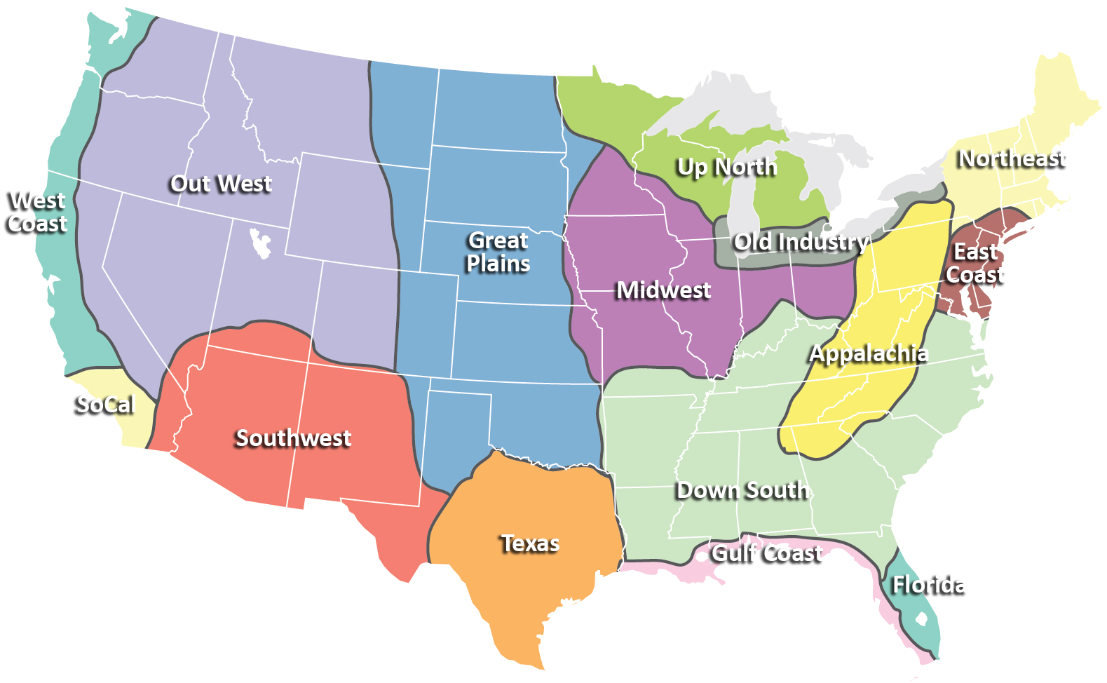
The following map gets into more detail, but may best define the regions of the nation as they are used colloquially:
And still others use “Great Lakes Region” to define what others refer to as the Midwest or East North Central states. Using “Great Lakes Region” creates more clearly defined borders with others regions such as the Great Plains and Mid-Atlantic states.

Many regions are defined by physiographic divisions. While the nation’s landscape hasn’t divided and defined distinct cultures to the extent that occurred prior to the Industrial Revolution and advances in transportation, terrain still plays a part in understanding regional borders:

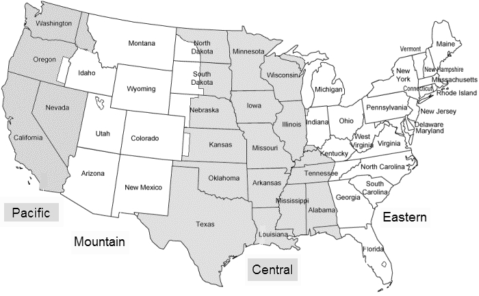
As few as four regions are used by some:

Here, six regions used and the Northern Plains and Great Lakes states are defined as the Midwest:

Many tourist guides define the regions of the United States as done below. The eleven regions are distinct and easily understood as varying in culture and topography. The Midwest is shown in blue:
Then there’s language that can help define the Midwest and other regions. Here, “soda”, “pop” and “coke” are mapped by usage at the county level. Clearly the Northeast, South and Midwest out to the Northwest are distinct:

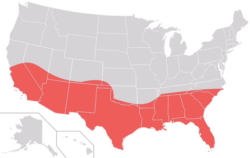
Lastly, some define the Midwest as largely encompassing the Rust Belt. The labels are different by nature and the difference is made clear when considering a region such as the Sun Belt (below), which by most definitions spans the nation from the Southeast, across the South and to the Southwest:
The Rust Belt can be defined against the Farm Belt and other regions. While covering much of what is understood to be the Midwest, the Rust Belt isn’t generally understood to extend west of central Illinois (though St. Louis is sometimes represented as an island of the Rust Belt):

