It's hard to avoid the anticipated cost of this project, though it serves no purpose to dwell on it. The previous number kicked around was $300M, a high enough price tag to make some skeptical. The $578M estimate is much more realistic given the scope and size of this project. It's an exciting number for those who want to see continued investment in downtown and the park.
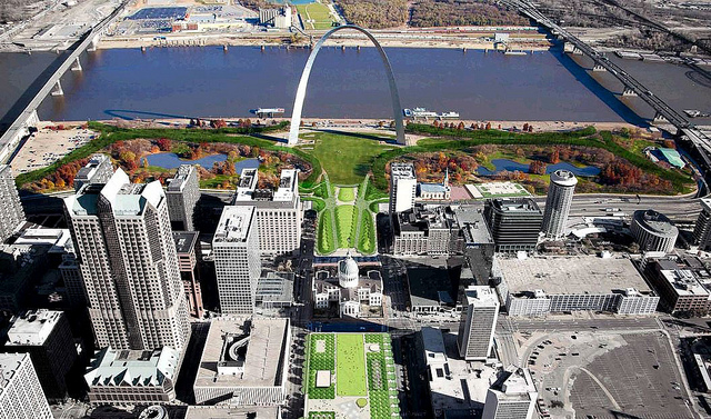
So what's changed since September 2010? The Kiener Plaza plan was reconsidered, as was Smith Square, which is now contiguous with the Arch grounds with a one-block lid crossing Interstate 70 and three-blocks of Memorial Drive is removed. A gondola is in, and may be funded with bonds as a revenue-generating amenity. The south and west parking garages are out and the focus will be to direct visitors to existing, underutilized downtown parking. The beer garden and ice skating rink may move to Kiener Plaza and the north trainspotting feature looks to be replaced by a more open rail line trench, allowing train viewing. The illuminated flood gauges in the river are apparently gone. The avian research center on the east side is delayed until 2016 when a new Illinois Route 3 will be completed. Click here for the full review of the MVVA original winning design. Complete revision public presentation is below.

{MVVA Arch grounds site plan 2011}

{MVVA Arch grounds site plan 2010}

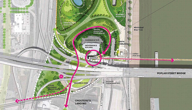
{Behnisch submission site plan showing gondola route}
The gondola proposed as an element of the MVVA plan parallels the Poplar Street Bridge. It can be seen at the very bottom of the MVVA 2011 site plan above. Once across the river, the gondola route turns nearly 90 degrees and lands near the existing Gateway Geyser. The route is no more than 50 feet from the PSB and will rise just above the highway, giving riders incomparable views of the Arch and cross-river traffic. The views will surely be amazing, but possibly less so than the proposed Behnisch route that would offer a more direct view of the Arch and city. Landing on the east side, visitors will find a 100,000 sq. ft. pavilion ready for a picnic at the Gateway Geyser.

{gondola profile}

{gondola route}

{south end keeps the maintenance facility and gets a gondola station}

{a pavilion will frame the Gateway Geyser}

{MVVA revised vision for Kiener Plaza}
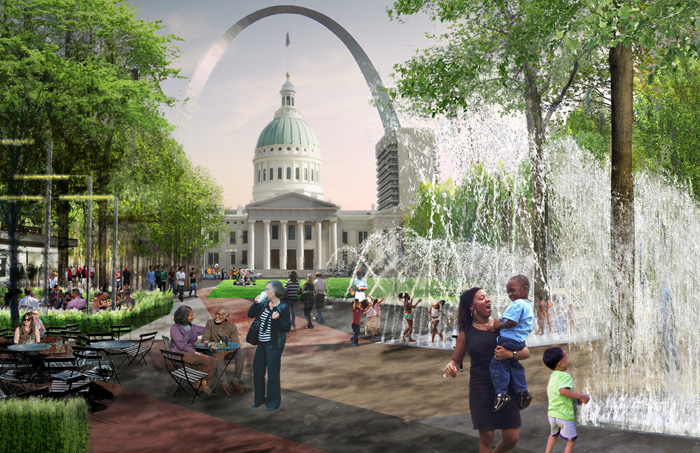
Kiener Plaza was relatively plain in the winning MVVA design. That's changed. The updated design seeks to continue on the success of City Garden and offer more activity, more movement, providing a setting for people to linger and enjoy. With The summer beer garden and winter ice rink have been moved here from the Arch grounds south end. A four-season carousel has been added, as well as a substantial water and restaurant. This is the third food service addition (Museum of Westward Expansion, Cathedral Square).

{MVVA revised vision for Kiener Plaza}

{MVVA 2010 Kiener Plaza design}
The plan for a Cathedral Square, a small pedestrian plaza facing the Old Cathedral and restaurant and banquet facility helping to frame the square is still in. The design team has apparently met with the Archdiocese of St. Louis and has its approval to move forward, albeit with some significant changes. Unfortunately, the new Cathedral square is half the size of the original design and the pavilion appears to have shrunk significantly as well. This is still a place I look forward to visiting, but a little less so now.

{Cathedral Square from MVVA – 2010 plan left, revision right}
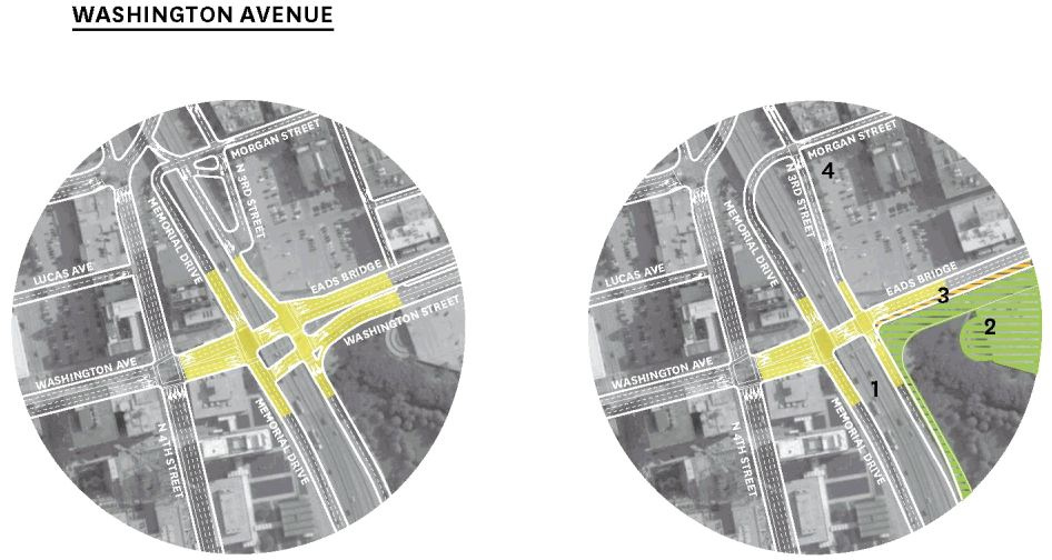
The winning design left Memorial Drive in place. The revised plan calls for one block (Market to Chestnut) to be removed west of the I-70 trench and three blocks (Walnut to Pine) to be removed to the east. This means that drivers northbound on Memorial Drive south of the Gateway Mall must turn west onto Walnut Street. Southbound Memorial Drive traffic north of the Gateway Mall will be required to turn west onto Pine Street. Northbound Memorial Drive north of the Gateway Mall will be removed and a new exit ramp will lead to Washington Avenue and the Eads Bridge, connecting directly to Third Street and Laclede's Landing. A new entrance ramp off southbound Memorial Drive is added opposite this. With Memorial Avenue removed, Smith Square is redesigned and, like Kiener Plaza, appears much more inviting.

{MVVA proposed changes to existing streets}

{the new Washington Avenue-Memorial Drive intersection}
What does the removal of three blocks of Memorial Drive mean to the effort to remove I-70 in downtown St. Louis? The group City to River has shown how an urban boulevard can work with the MVVA designed lid. The boulevard simply takes the place of the Interstate in the trench, dipping under the lid, reconnecting the street grid where possible and eliminating the elevated lanes north of Washington Avenue.

{City to River boulevard with closed Memorial Drive}

{revised vision for Smith Square and museum entrance}

{2010 MVVA Smith Square and Memorial Drive design}
The redesigned Smith Square highlights the allees extended into the city and aims to visually connect the Arch grounds to the city. MVVA plans to plant approximately 12,000 native trees along the Gateway Mall and throughout the Arch grounds. This includes the replacement of the existing Ash trees in anticipation of the Emerald Ash Borer beetle.

{ramps will address ADA compliance and the train trench may be made more visible}

{design of interior park landscaping remains unchanged}
OVERALL PROJECT STATS:
- 16 acres of new Park space including: Kiener Plaza, Luther Ely Square, Washington avenue, North Gateway and the South Gateway surrounding the existing maintenance Facility.
- Over 25 acres of landscape improvements on the Arch Grounds.
- A least 50 acres of East Bank added as National Parks land and continuing to explore further potential land acquisitions for the East Bank Park.
- 12,500 Native Missouri and Illinois trees to be planted.
- 3.5 miles of new accessible pedestrian pathways creating universal access across the project area.
- Over 9 acres of new community oriented event space.
EAST BANK PARK:
- 100,000 SF pavilion area with shade canopy with animated fountain elements centered on the Gateway Geyser.
- 1 Mile long Gondola ride from the South end of the Arch grounds to the East Bank’s Malcolm W Martin Memorial Park. The Gondola cabins will be customized for the City Arch River project and special cabins will include glass floors for exciting views.
RIVERFRONT:
- Accessible and more event friendly waterfront between the Eads and Poplar Street Bridges (.7 miles)
- New bikeway connections at the north and south ends of the Arch Grounds & Riverfront.
THE MUSEUM:
- 50,000 SF of new museum and event space with a new glass façade entry opening facing Luther Ely Smith Square, bringing daylight underground and enhancing the terminus of the Gateway mall.
- Over 100,000 SF of existing Museum space will be renovated and include new exhibit space and increased public educational space.
THE NORTH GATEWAY:
- Replace a 4 acre parking garage with community oriented landscape. 20,000 SF Children’s Garden area.
CATHEDRAL PLAZA:
- 9,300 SF Restaurant / Pavilion with roof terrace.
LUTHER ELY SMITH SQUARE:
- Land bridge connection between the Arch grounds into the City over the I-70 highway trench. Removal of 75,000 SF of Memorial Drive. 3.5 acres of new landscape and plaza.
THE OLD COURTHOUSE:
- 13,000 SF of renovation for galleries and exhibits. New ADA access.
KIENER PLAZA:
- 9,000 SF interactive water feature and Children’s Play area
- 32’ diameter Carousel
- 6,500 SF Concession & Performance buildings
City Arch River 2015 – MVVA Update Public Presentation 01-26-11


