
This is the fourth of five full reviews of the Framing a Modern Masterpiece: City + Arch + River design competition submissions. Each review focuses specifically at treatment of Kiener Plaza, the Old Courthouse, I-70/Memorial Drive, the Museum of Westward Expansion, the Old Cathedral, the Arch grounds north and south ends, the riverfront, cross-river connections and the east side as well as overall feasibility and overall excitement. Each of the five final design full narratives can be viewed on nextSTL here.
______________________________
Kiener Plaza
The plaza is flattened, but gains motion at the same time. The initial impression is dominated by artist Jaume Plensa’s “Whispering Leaves.” The largest leaf would house a cafe, others may have water falling from their upper edge. The leaves themselves are comprised of letters which would appear as an open lattice from any distance, the distinct letters blending together.
The leaves would bring welcome visual interest, placing more sculpture on the Gateway Mall and providing some continuity with City Garden. The artist predictably uses many metaphors to explain the leaves, “Every leaf is different and unique, but together they make a tree, like people making a community.” I can see the leaves becoming a landmark, but I can also see them becoming dated in a decade or so.
The other nice decision made with Kiener is to include wide tree-lined walkways on the edges by narrowing Market and Chestnut. One can walk straight down the axis of the Mall, but the leaves, varied surface treatment and irregular shape of the lawn should pull people to explore Kiener in a new way.

Old Courthouse
A “two museum” experience is how SOM describes their plan, and more than any other design team, they appear to have taken the time to plan a purposeful integration of the Old Courthouse into the park. In addition to making the entire building ADA accessible, they offer to open more of the building to the public, restore interiors to 1862 and focus exhibits on how this site become the “test of the American idea.”
Reading the SOM design narrative makes the re-imagined Courthouse seem like an obvious development. That’s what good design does. It would seem that other teams have missed a clear and natural way to pull the Arch grounds into the city, or at the very least, they missed an opportunity to more fully explain a higher use for the Courthouse in the context of the larger park. This highlights one recurring theme of the SOM vision, placing more programmed activity at the periphery of the park to serve as activators of space as well as effective gateways to the Arch and river.
I-70/Memorial Drive
Very similar to MVVA, SOM more or less leaves the existing Memorial Drive in place. Both plans offer lids just under 700 ft., the limit after which considerations such as security and ventilation make the cost prohibitive. But instead of making the land between north and southbound lanes a green, but unwelcome space, SOM flies in a “magic carpet.” They have taken the concept of a flat lid and peeled back the ends, folding them over at each to create space for a cafe and information center.
The magic carpet is an innovative way to activate this island between lanes and something that Boston’s Atlantic Avenue (site of the Big Dig), with even more space between roads, could learn from. SOM also plans for the future removal of I-70 downtown. Dedicating a couple pages to the concept and its benefit, the design narrative spells out their support, stating, “the design team supports the efforts put forth by City to River in advocating for the removal of I-70 between Cass Avenue and the Poplar Street Bridge, and its subsequent replacement with an at-grade signature boulevard to better connect the city to the river.
The rough rendering showing I-70 removed and a split Memorial Drive basically leaves this substantial space between north and southbound lanes to be planned later. This is a design that should be further refined and it appears that SOM may have under-designed this area in anticipation of future changes. Compared to all but the MVVA proposal, the design here feels temporary. Even the magic carpet first reminded me of a Band-Aid. A more permanent change offered is to make nearly all city streets two-way, “Don’t close streets, just narrow them,” the proposal states.

Museum of Western Expansion
The expansion of the museum is less dramatic. The curved glass entrance near Memorial Drive and facing the Old Courthouse is purposely invisible from the Arch and the rest of the grounds. This is a good plan in the sense that it provides the least disruption in the landscape (SOM happily disrupts the landscape elsewhere), but it seems a more prominent entrance may help direct people from the west, south and north toward what will be the central, most dominant point of entry to the park and best entrance to the museum.
Perhaps the museum isn’t as radically different because SOM sees an increased mission for the Old Courthouse and attractions at the north and south ends of the park. Two sweeping ramps outline the new exhibit space, with one serving as an entrance ramp and the other an exit. The design would provide a much more open experience than currently exists, but with no skylights and a purposely understated entrance, the new space even appears dark in the renderings. It’s almost as if the new space was meant to reflect the current space. That seems like a bad idea.
The interesting and unique touch here is the inclusion of a “Gateway Arch Center”, dedicated to the history of the built environment that has existed on the site. SOM states, “The idea is to enthrall visitors already absorbed by urban and industrial design and engineering, and provide an accessible set of experiences for those who might not normally be interested.” That’s easy to like and seems appropriate for an urban National Park. Live video feeds of the Arch above (why not put in a skylight?) and various models of the Arch will focus on the artistry of the incredible structure itself, building anticipation and appreciation of the experience ascending the Arch.
Old Cathedral
Given the attention to detail and re-purposing of local resources (Old Courthouse, MacArthur Bridge, Cargill site, etc.), it’s disappointing that SOM did not offer a design that incorporates and highlights the Old Cathedral.
North end
SOM keeps Washington Avenue in place as an important connector to our river. This is important because Washington Avenue is the only street that connects the central city west of Memorial Drive to the waterfront. Serving as the city’s commercial Main Street, a visitor should be able to drive down Washington Avenue and have direct access to the Arch grounds. By every other route, a visitor must make multiple turns to reach parking, or, importantly, a better understanding of the lay of the land.
While other teams have considered how to locate outdoor activities on the north and south ends, SOM went the extra step and rethought the purpose and format of this desired activity. They’ve introduced sculpted landscapes that improve access, preserve views, creating new entrances to the park that have the potential to eclipse that of the visitor entering from the Gateway Mall. This is a significant achievement.
Not only do they accommodate buses with a drop-off turnaround, and parking, there is also space for a bike rental station, a public auditorium and conference center as well as exhibition space and a restaurant. The sculpted terraces are artful in their own right, but the central terrace provides a striking moment as it reaches over Washington Avenue and touches the Eads Bridge halfway between 1st and 2nd Streets, providing access to the promenade and bike path on the bridge. It’s one of the few moments of truly inspired design in the competition.
The North end plan envisions an “orientation hub” giving visitors a sense of the monument’s place in the city and region. Specifically, they propose a large (~40x40ft) scale model of downtown St. Louis. It’s rather simple, but an element that is sure to be popular and educational. A visitor could learn more about the development of the city and also locate their hotel and next destination, City Museum, Busch Stadium, the Peabody Opera House?

South end
“100% Park and 100% Village.” It’s an awful PR line, but at the same time a perfectly apt description of SOM’s vision for the South end. It’s also a good enough idea that despite the elegant design of SOM’s North end, I find myself wondering if it could be re-imagined the same way. The area mimics the flowing physical landscape of the Arch grounds and offers an urban street grid.
As with the North end, the proposal here introduces far more programmable space than any other design. This provides for a dynamic and unexpected entrance for visitors and builds in consistent activity in the form of employees, classrooms, volunteer center and more. Included in the design are a visitor and learning resource center, auditorium, cafeteria, exhibition space, assembly/sports hall, library archives and NPS office and maintenance space. Activity extends beneath the Poplar Street Bridge with basketball courts, a soccer field, hockey rink and skate park.
While other teams envision activities here (see ice skating rink, natural amphitheater for movies, etc.), SOM prescribes a multi-dimensional active “village” with facilities that will see routine public use. Along with MVVA’s Cathedral Square, if built, this area would be common stop on my visits to the Arch.

Riverfront
Lenor K. Sullivan Drive is closed in this proposal as well. SOM raises the promenade six feet to reduce flooding by 30% (another two feet would cut the risk another 10%), creating a more reliable setting for festivals and other activities. The proposed redesign is more functional, but it’s also quite generic. With “scalloped seating terraces”, more like big steps one can sit on, along the length of the riverfront, the design introduces casual seating, but nothing that embraces the history of the St. Louis riverfront like extending the cobblestone wharf towards the park. The nice touch here is the addition of three rows of shade trees on the promenade with a break only for the Grand Stairs. This makes the riverfront a true promenade as the shade would welcome visitors to stroll the length of the park.
SOM reaches a little in their plan for activating the riverfront as well, envisioning a floating pool in the Mississippi. The plan states that the floating pavilion, “captures a fragment of the Mississippi and tames its currents and cleans its waters to make it accessible for the urban life in the form of a public pool.” SOM says they can employ “inexpensive filtering technology” to make this happen. This could be a huge attraction and in terms of adding an amenity to downtown living it could be big. Where does someone downtown who wants to swim laps go? Of course it would at times be an overcrowded tourist draw as well as likely being closed due to flooding for a few weeks a year. As with other tempting floating attractions, this may be best left on the drawing board.
Cross-river connections
The Eads and MacArthur serve as bike and pedestrian connections between the east and west sides. The Eads gets the half-and-half treatment, reducing car traffic to two lanes and giving the south side to bicycles and walkers. A ferry service to the East side is offered as well. The design does go one step further and plans for new and better access to the Eads deck on each side of the river.
SOM isn’t the only team to see the MacArthur Bridge as an important connection (Behnisch gave it a mention as well), but they are the only team to include a rendering and statement as to how this might work. The rendering more or less is a take off on the High Line in New York City with native vegetation, a paved portion and what looks like a boardwalk. Here again, SOM spells out connections, including a 7th Street bridge ramp entrance.
Ultimately, I think a new pedestrian bridge that obscures the Poplar Street Bridge from the north (MVVA and Weiss-Manfredi) is the best solution as such a bridge would visually complete the larger Arch grounds, giving a visitor the Arch, Eads Bridge, pedestrian bridge and the new elements on the East side to view. And a bridge connecting directly to the Arch grounds is much more likely to be used by visitors who would be able to see exactly where it leaves and lands. That said, the MacArthur should absolutely be re-purposed and SOM recognizes this.
I’m not convinced that a ferry service connecting the two riverbanks works well, although it would serve a particular segment of Arch visitors. Maybe something more than simply crossing the river would help, crossing under the Eads and possibly the PSB and MacArthur would add some excitement and opportunity for education, more similar to a tour boat exploring the Golden Gate, or the architectural boat tours of Chicago.
East side
More than any other design team, the focus on the East side is the built environment. In this case, the built environment spans some 1,200 years. While PWP places a single, large conical mount on the Arch axis on the East side, SOM introduces a “mound park”, a series of seven mounds of varied size and position, clustered together on the southern part of the park. Walkways, at times elevated and at times on the ground circle the mounds in irregular ovals, offering a variety of ways to navigate the restored wetland area. Although the renderings show visitors on each of the larger mounds, it’s unclear how accessible each would be from the paths.
For anyone who has seen the renderings, the mounds aren’t the most noticeable element in this plan. Four giant heads (think Easter Island) approximately 100 feet high emerge from four of the larger mounds. The detail provided about the heads themselves states the sculptures, titled “Mississippi Soul”, “reflect the spirit of empowering women, hope and optimism.” Given precedents for the heads include “Buddha, Easter Island, Angkor and faces in the surface of Mars planet, etc., etc.” This seems to be a poor fit for celebrating the Mississippian Native American Culture. The heads give visitors something to visit, something to see from the opposite shore, but I can’t decide if giant heads emerging from fake Native American mounds produce positive curiosity or simply a sense of weirdness.
The central, if understated, addition to the East side is an 11,000 seat amphitheater with 4,000 permanent seats. Billed as a “permanent home for music and celebration” and a possible summer home to the St. Louis Symphony Orchestra, the venue would provide an incomparable backdrop to any performance. In general, I don’t like the idea of a performance venue that would sit silent often. A purpose-built venue of this size could fill a niche, but concerts and other events are much better suited to the west side, where concert goers can eat downtown and add to the vibrancy of the city.
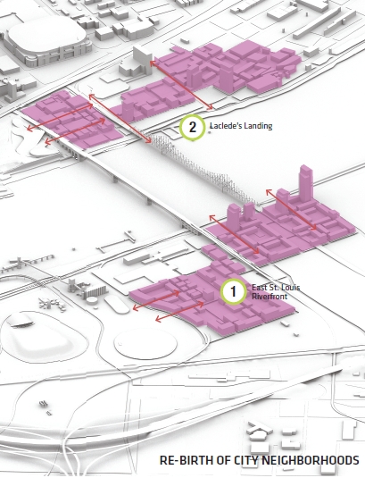
After all that, SOM isn’t done with the East side. The design team envisions the “re-birth of city neighborhoods.” The idea is that the land surrounding the landing of the Eads Bridge (and MetroLink station) could become an urban neighborhood, one with incredible views of the Eads, Arch and city. This is a post-2015 vision and shows SOM spent time thinking through the economic development opportunities presented by redevelopment of the park. They also spend some time re-imagining the Cargill plan, labeling it the “Cargill Center for Sustainable Cities and Rivers” and rendering a concept for the existing structure showing an aquarium and and exhibit space focused on “riverine ecology” and “urban design.”

Feasibility
The SOM plan appears to successfully blend artistry with significant development. The signature moments, “whispering leaves”, the “magic carpet”, direct Eads access, mounds, giant heads and amphitheater all seem very reasonable. The re-purposing of the MacArthur may be more challenging, but should be realistic. The swimming pool? Who knows. The north and south ends are big endeavors, but not overly-ambitious given the project timeline. The big goals, removing I-70, re-purposing the Cargill silos and creating a neighborhood on the East riverfront are aspirational and would serve as longer-term goals.
Excitement
The museum is understated, the central Arch grounds see little change, but there’s a lot to be excited about in the north and south ends and use of the MacArthur Bridge. The smaller elements do not stand up and shout to be recognized, but each one adds style and function to a visit, the Eads access is unexpected and memorable, the model of the city isn’t an entirely new idea, but is welcome, changes at the Old Courthouse would reintroduce an exciting building to even locals. The plan offers contextual excitement. With the Arch as the focus of the visitor experience, perhaps thats the excitement we should seek.
