
 If road builders were your physician, you would cough and get a lung transplant. This is what's about to happen in south central St. Louis County the South County Connector study rolls on. The 1957 concept of an inner-ring Interstate simply won't die. The idea that we must build highways to connect all Interstates, parkways to connect all highways and arterial roads to connect all parkways is more difficult to kill than an army of zombies. We continue to build for 20 years ago and by the time planning and building catches up with reality, we will have overbuilt our infrastructure once again, destroying part of our civic fabric in the process, which once gone, cannot be reclaimed.
The question at hand is how many homes is it worth for a relatively small, defined area of South County to save a few minutes getting to Clayton, or shopping centers in Brentwood and Richmond Heights? St. Louis County lost population from 2000-2010. It's time to rethink projects set in motion 50 years ago. Access to County government is cited as once reason to build more and larger roads. Yet this is becoming less of an issue all the time. One quick example: one can challenge assessed property value in St. Louis County online in approximately five minutes – no need for a $200M roadway project. Times change, trends and needs change, unfortunately road projects seem to lurk long enough to climb the funding ladder and eventually get built, independent of changing factors or community needs.
Major highway projects have been proposed to connect this area with Clayton, I-44 and I-64 on a regular basis since the concept emerged in 1957. Each time, residents have successfully rallied in opposition. It appears residents remain well-versed in what's coming their way. From a recent KMOX news story: "(The vacant Deer Creek shopping center) would be the better area," said a Shrewsbury resident concerned about a highway cutting his city in half. That said, he added, "it seems like the County is saying "let's spend some money."" Well said.
So who is on the other side of this equation? "Those in the path this time are weary while Clayton commuters say "bring it on"," is the simple explanation offered by a KMOV news story. As reported in the Post-Dispatch coverage of the issue, St. Louis County Officials claim that those living in the southernmost portions of the County suffer "very poor" access to the commercial and governmental core of the region. How is this defined and who will be listened to this time around?
A 1997 study concluded that Brentwood, Big Bend, Hanley and Laclede Station roads would continue to serve as north-south arterial corridors. It also recommended extending MetroLink within the corridor. The Blue Line now runs to just south of I-44 in this area. Another study in the early 2000s recommended a number of solutions, including traffic signal coordination, minor and major improvements to existing roads and possible roadway realignments. A study examining options for adding a full Interstate interchange for Shrewsbury at I-44 was completed in 2004. A new interchange is now included in the East-West Gateway long term infrastructure plan at an estimated cost of $74M.
The Hanley Road corridor study was also complete in 2004. The study recommended reconfiguring the Manchester Road intersection at Hanley. The "Michigan Left" intersection planning is nearly completion and would cost $50M to complete. nextSTL noted at the time a preliminary design was released, that $50M could provide free Metro transit access to everyone in the St. Louis region (Mass Transit for All v. One New Intersection).
Nearly every local news story regarding the project noted that even if the project is approved, that further study will take two years and that there is currently no money allocated for the project. This is an all-too-common statement that seems intended to misdirect those concerned about development. Sure, your house may be bulldozed, but approving this plan doesn't guarantee that it will happen soon. Instead, why isn't the local news stating that if citizens want to get involved, the time is now and only now? How many times must the region hear, "don't worry, nothing we're doing is final," before we understand the need to be involved in the process from start to finish.
What is the stated purpose of the ongoing study and possible roadway project? The following are listed as under "Purpose and Need" on the project website: Improving roadway connectivity, Reducing congestion in the study area, Increasing roadway capacity, Considering the needs of bicyclists and pedestrians.
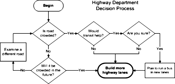
Are any of these actual needs? Why not, "Reduce travel time from Shrewsbury to Clayton by five minutes."? That would tell us what we're getting from the project and facilitate a discussion regarding the balancing of a concrete need with the physical impact and cost of the project. And no matter what is said, bicycles and pedestrians are not even a minor motivating factor in this project. That's not how road projects are designed and built. This flowchart likely comes nearest to how we make road-building decisions in this country (via greatergreaterwashington.org):
So what is the study studying? The alternatives listed are: No Build, Transportation System Management Options and Build Alternatives. Only, there are five build alternatives. The aim of the study is the decide what to build. For all the reasons already address, I would support the no-build option first. If federal money is burning a hole in our DOT pocket and road builders are twiddling their thumbs and something just must be built?
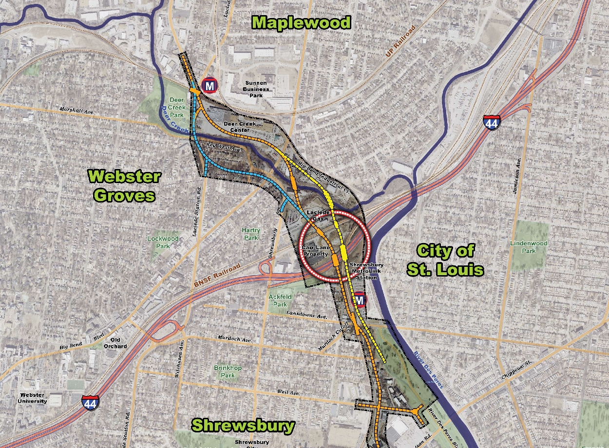
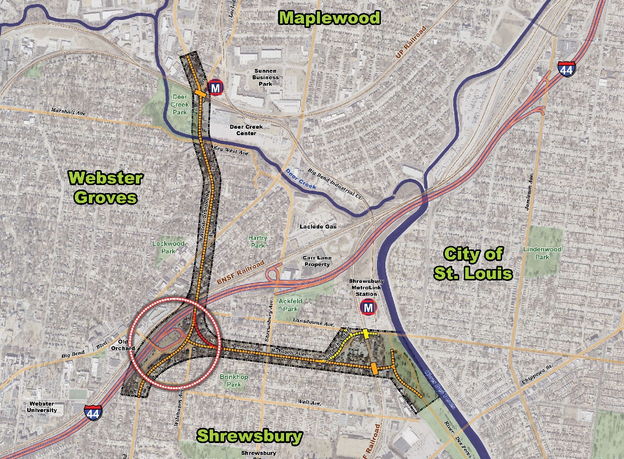
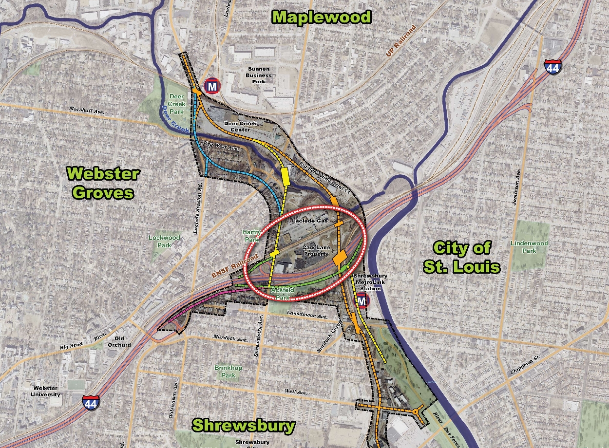
If something is to be built, the priority should be to avoid residential property impact, improve multi-modal transit access and create development opportunities on underutilized land. The River Des Peres Extension best achieves these goals. While several alternatives of the extension are presented, the best option is to extend River Des Peres Boulevard north, creating a full interchange at I-44, then crossing the Deer Creek before traversing the Big Bend Industrial Court and Deer Creek Center.
Opening these areas to development could be a big positive, but avoiding residential property and traffic impacts are the goal. Residents in the development area have successfully opposed the bulldozing and splitting of their communities in the past, let's hope the balance of building ever more for commuters and shoppers as the expense of residents can be titled in the right direction again for this project.
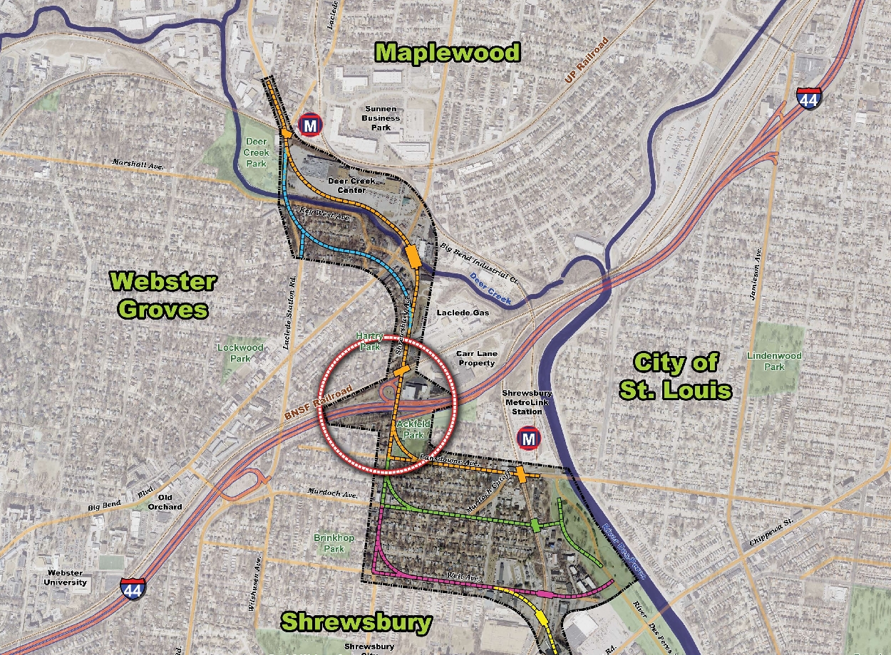
{River Des Peres options}
{Laclede Station Road options}
{South Outer Road options}
{Shrewsbury Avenue options}
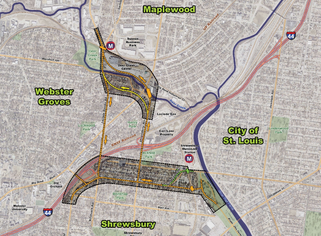
{local roads options}
