
WSP USA conducted a traffic calming study of the Skinker DeBaliviere neighborhood for the city’s Board of Public Service at the behest of Alders Clark-Hubbard and Navarro through ward capital funds. The WSP team carried out a community engagement process and examination of infrastructure to identify problem spots and make recommendations.
Goal: Improve walking and cycling conditions throughout the neighborhood or comfort, safety, accessibility and enjoyment. Balance vehicle circulation and parking needs with pedestrian and cyclist safety and accessibility. Promote walking and cycling as realistic and convenient modes of travel
Skinker DeBaliviere Neighborhood Plan


The study identified speeding, lack of stop sign compliance, poor connectivity and circulation due to street blockages (#Healthegridd), missing marked crosswalks, wide crosswalks, and poor lighting.


The recommended implementation outlines three phases to meet funding as it becomes available. Phase one projects could include speed humps in the middle of blocks, bike cut throughs in the angled street blockages on Rosedale, painting crosswalks and curb bump-outs.


Speed humps located mid-block along Waterman and some other blocks built in phase one could be upgraded to mid-block crosswalks later. Also painted crosswalks and curb bump outs at intersections could be upgraded to physical bump-outs and raised intersections.


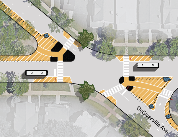
The biggest phase one project recommended is at the Waterman/Laurel/DeGiverville triangle. There is a lot of pavement that induces jaydriving there. The vision uses bump-outs and islands to reduce the space for vehicles and narrow crossings for pedestrians. DeGiverville would be one-wayed from Waterman to Laurel as it is on the 5800 block to reduce driver confusion. There is no crosswalk across Laurel, so there’s some more work to do on this design.

Phase three is maybe possibly looking into to considering the impacts of conceivably perhaps at least studying removing some of the street blockages.
These improvements, that should really be considered basic infrastructure all over the city, are most welcome. Of course the rub is funding. Due to the region being too spread out we’ve burdened ourselves with too much to take care of making it harder to do things like recommended in this plan. Imagine how much of these sorts of things that could be built for the cost of one fewer new highway interchange on the edge of the region. Funding will likely come from ward capital funds. Hopefully partners can chip in on some items such as the institutions and tax-incentivized developers in the area.
