A recent traffic study was completed on Hampton Avenue between Chippewa and Gravois.
Per St. Louis City: the purpose was to “determine the feasibility of reducing traffic lanes along Hampton Avenue between Chippewa Street and Gravois Avenue. The motivation for reducing lanes or implementing a “road diet” is a desire for Hampton Avenue to more effectively serve all users of the street, including pedestrians, cyclists, transit users, and motorists. Today, Hampton Avenue functions as an arterial street that prioritizes vehicle traffic over other modes. Hampton has two traffic lanes in each direction. Traffic signal cycles are long to accommodate through traffic. Many areas along the corridor lack adequate pedestrian and bicycle infrastructure.” (source)
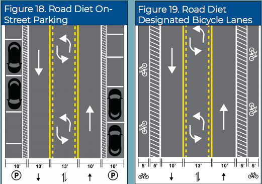
While I assume most readers who visit this site likely know what a “road diet” is, in this particular traffic study, the road diet reduces four lanes of traffic down to three, with one lane in each direction with a two-way center turn lane.
This lane reduction would enable a dedicated parking lane in high-traffic business areas or bike lanes in each direction with a buffer between cars and the bike lane.

I love seeing neighborhoods and the city in general addressing issues like streets, pedestrians, and business-friendly corridors.
And, I am one of those nerds who knows nothing about fluid dynamics, traffic engineering, urban planning, etc., but man do I love reading about it. I like trying to be a more educated driver, pedestrian and citizen.
Otherwise, living in one city your whole adult life can become boring.
And believe it or not, these reports tend to be written not as much for the learned/academic planner community, rather the common citizen since these studies tend to be funded by tax dollars and grants.
When I drive up and down Hampton I will now be hyper-aware of how things flow. The data shared herein and improvements outlined within this report will be in my mind on trips to and from Target and other frequented places in this part of town.
Hampton is a worthy test case for a road diet study, but Hampton is not unique to St. Louis as a cars-only street.
Jefferson, Grand, Kingshighway and Hampton might be the most common overly-wide north-south streets that cater only to the needs of cars. Pedestrians, neighbors and businesses are not part of the current equation.
But the list could go on and on. Tucker Boulevard (12th Street) downtown is extremely hard to cross on foot/bike.
Are streets have evolved into conduits to move car traffic as fast as possible and nothing else, but they don’t have to be that way forever.
South Grand between Arsenal and Utah recently had a road diet and it works extremely well. At first I wasn’t so sure, but now that I’ve educated myself and become accustomed to it, I’m a proponent.
Hence, this stretch of Grand has become the most civilized and a great example for urban retail/entertainment corridors in St. Louis. It won awards for its “Complete Streets” initiative, that sought to do exactly what can be done on stretches of Hampton Avenue.
Grand has the advantage of older, densely built mixed-use buildings compared to Hampton, but the concept is the same.
South Grand was even recognized as a “Great Place in America” from the American Planning Association following the road diet.
“Before the corridor’s renovations in 2015, South Grand Boulevard traffic averaged speeds of 42 miles an hour. Accidents averaged 80 per year. Recognizing the threat this throughway posed to the neighborhood residents and property and business owners of the South Grand Community Improvement District lobbied for the adoption of their “South Grand Boulevard: Great Streets Initiative” in 2011.
The city decided to run a 30+ day trial of the program with the goal of enhancing the appearance of the street, providing greater opportunities for economic development, and increasing pedestrian safety without compromising traffic efficiency. After finding that 73 percent of the public supported the alterations after the trial period, city officials decided to make the plan permanent. The rate of accidents has been greatly reduced while commercial activity has soared due to the road diet; the number of travel lanes and effective width of the road is reduced in order to achieve systemic improvements.
— http://southgrand.org/
Road diets are a proven measure to increase safety and make a street more multimodal.
Hampton Avenue is a great choice for a study like this. It is flanked by stable, high-density neighborhoods with lots of functional businesses.
First a little background on Hampton Avenue.
Hampton connects Forest Park at its norther terminus with Gravois at its southern terminus. The full stretch is right around five miles.
Per the St. Louis Street Index, “Hampton Avenue takes its name from an urban district in Middlesex County, England. The name first appeared on St. Louis maps in 1913 when the thoroughfare known as Sulphur Avenue between Bancroft and Loughborough was renamed Hampton. The section between Oakland and Manchester avenues was named Billon Avenue until 1921.”
I was thrilled to learn that a traffic study was conducted to evaluate possible changes to reduce car traffic, improve pedestrian/cycling connections and make the dense business districts more attractive/viable and part of the neighborhoods.
The October, 2020 study focused on the ~2.1 mile section of Hampton from Chippewa to Gravois, the southern section. Think Target to Willmore Park.
I poured over the Hampton Avenue Traffic Study report with my amateur eyes. The study was conducted in 2019, submitted to the St. Louis Board of Public Service in June, 2019. It was prepared by Lochmueller Group (St. Louis) and Engineering Design Source, Inc. (Chesterfield, MO). Public feedback was received and considered and now it is on the books.
Now will we DO anything about it?
When you think about a road diet, you can imagine who would be most against it: fast food chains. Their modus operandi is get in and get out ASAP. Dedicated curb cuts that allow as much traffic as possible to funnel through their drive thru lanes. That is it. Their business model is the opposite of the small, locally owned sit-down restaurants that want you to have a nice aesthetic experience as well as a good meal or drink.
The latter would clearly benefit from reducing a lane of traffic to include more convenient on-street parking or attractive sidewalk seating.
The study measured current traffic volumes and compared the current conditions to the road diet configuration. The counts were taken during rush hour in February and March, 2019, pre-COVID so it was legit.
Road diet studies also include assessments of the traffic operations, parking, and safety of signaled intersections. For this particular study, eight separate intersections were evaluated.
First some statistics I found interesting from the report:
- Hampton is ~55 feet wide
- There are five lanes from Chippewa to Lansdowne and mostly four lanes south of Lansdowne
- The daily traffic volume was 16,332 vehicles per day.
- The posted speed limit is 35 MPH; the 85th percentile speed (which is the speed at which 85 percent of the motoring public are traveling at or below) was 37.3 MPH. Only a small fraction were over 46 MPH between Delor and Itaska.
- There are ~500 on-street parking spaces. Usage was overall very low, peak usage was at lunch (~9% usage) and dinner time (~17% usage).
- Six of the seven signaled intersections are coordinated by the city to keep traffic flowing north/south.
- The Gravois and Hampton intersection is operated by MODOT.
- Sidewalks line both sides of Hampton. Yeah!
- Eight intersections have signaled pedestrian crossings
- Dedicated on-street bike lanes are marked on both sides of the street south of Robert Avenue. While the northbound on-street bike lane continues south to Gravois Avenue, the southbound lane is interrupted by on-street parking adjacent to Willmore Park and returns to a share-the-road configuration.
- Pedestrian volumes were characterized as modest while bicycle volumes were nominal (it was winter though).
- Bus service is provided at 30-minute headways throughout the day with additional service during peak periods. There are 11 southbound and nine northbound bus stops in the study area, none of which have covered shelters.
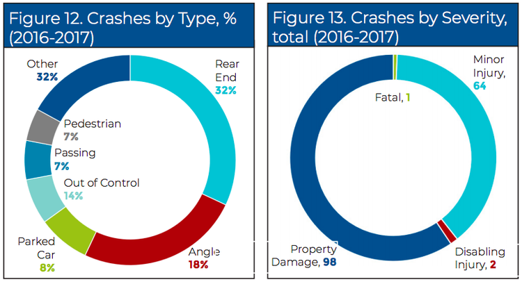
- Here’s the safety data:
While the firms that conducted the study do not make a recommendation for or against a road diet, they do offer some suggestions on what it would look like.
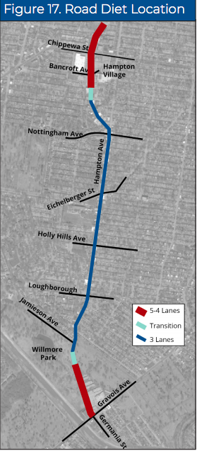
The road diet from 4 or 5 lanes down to 3 would essentially run from Landsdowne to Jamieson. This allows a “funnel” where more lanes are needed at Gravois and Hampton/Germania to the south and Chippewa and Hampton to the north. The latter is one of the busiest intersections in St. Louis.
The parking lane along Willmore Park was not in heavy use, so the recommendation would be to include dedicated bike lanes to mirror the other side of Hampton in this section.
Some intersections would be reconfigured to include short dedicated right-turn lanes. All signalized intersections would include physically raised curb bump outs to reduce intersection wideness, shortening pedestrian crossing distances.
I found the following interesting: “Intersection improvements to increase safety are merited at the Hampton Avenue and Jamieson Avenue independent of the “road diet” alternative. This intersection is excessively large and lacks any pedestrian crosswalks, despite adjoining residential and recreational (Willmore Park) uses. This intersection was the scene of 2 serious crashes (1 fatal and 1 with disabling injury) during the recent 2-year period. Recognizing funding limitations, the “road diet” alternative reduces the size of this intersection with painted pavement and a physical bollard or planter. The eastbound approach is reduced to 2 lanes (1 left-turn and 1 right-turn). Just a single lane departs the intersection in the westbound direction. Pedestrian crosswalks are provided across the west and north legs. Given the volume of traffic on Hampton Avenue and the absence of a traffic signal, a pedestrian refuge is added in the median of and rectangular rapid flashing beacons are provided to improve safety.”
Now for my opinion…we need a road diet project on-going at all times in St. Louis. Studies may be necessary and that great, but a project has to be underway at all times. We have to DO and not just study.
We need road diets north to south, east to west, all over the city. I commend the neighborhoods of St. Louis Hills, Southampton and Princeton Heights for taking this seriously.
We need to chip away at the over-engineered, over-wide roads all over the city. Look at the mess of Tucker Boulevard Downtown/Downtown West or Jefferson or Natural Bridge. Come on, these are too wide and dangerous.
Streetcars once shared many of these streets, so there was a reason they were built so wide, but those days are long gone. Our city streets need a diet.
Hampton is a great target for a road diet, but there will be naysayers. Count on it.
They will have grey hair. They will talk at the highest volume in the room. They will say Hampton is too crowded and a lane reduction is a preposterous idea. Yet, this study pointed out that industry professionals suggest that a street is a candidate for a 4-lane to 3-lane “road diet” if the average daily traffic volume does not exceed 20,000 vehicles per day. The daily traffic volume along Hampton Avenue was 16,332 which is well below that threshold.
There will be a faction that says “why Hampton, it’s too far gone”. It’s an auto-centric disaster, move to the older part of the city for this kind of work. I don’t buy that. These high-density neighborhoods are very stable and deserve a decent stretch of Hampton to shop, dine and hang out.
Bike lanes on this stretch would be welcomed as well.
There will be opinions that if you reduce a lane of traffic on Hampton, people will just move to the intra-neighborhood streets to avoid it. The published research data suggest that traffic diversion to parallel routes from road diet implementation only ranges from 2% to 15%. Not a big deal, and with the proliferation of speed humps in intra-neighborhood streets, speeding has been greatly reduced in recent years on neighborhood streets.
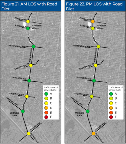
Intersection wait times will be largely unchanged, if not improved. The wait times at Eichelberger and Nottingham may be increased but for most signal cycles, all vehicles in queue would clear the intersection on a single green. Intersection “level of service” for the morning and evening peak hours with the “road diet” concept are shown below, all is flowing well as you can see, no problem intersections at either morning nor evening rush hours.
Again, the study showed that most intersection service times would be unchanged and some even improved, like the Loughborough one.
The relatively low speeds travelled today indicate that it would not be a drastic sacrifice to reduce traffic lanes. People are largely obeying the speed limits (between Delor and Itaska anyhow where speeds were measured).
We need more on-street parking, we need more protected bike lanes. I’m perfectly good with a 5 foot space between the bike and car lanes.
Parking along Hampton can be scary, very close to the traffic lanes and opening your door can be sketchy due to the bends in the road and the speeds traveled.
What about cost? Of course there will be public investment necessary to improve the area for residents and businesses. The cost estimate for the cheap/re-striping-only concept is $193,680. I say don’t stop there, go whole hog and the impact will be noticeable and permanent. The cost estimate of the full road diet concept is $916,301.
I see this as a righteous use of tax dollars as this part of the city is tremendously dense and the business landscape is varied and valuable to residents.
The impact would be high profile and welcoming to new residents who include walking and biking as priorities in where they will choose to live. If a small restaurant wants a walkable, less speedway-like view from the sidewalk, this will help.
In COVID times when going places has become impossible, riding a bike has become a metal health benefit for me personally and dedicated bike lanes, especially on Russell and Broadway have been great, but a 5 foot buffer between the car and bike lanes would bring me much personal confidence and an aire of safety.
I’d happily ride Hampton on the regular if this existed.
Today? Forget about it, no way am I riding a bike on Hampton.
Let’s make this happen, and then move on to the next target for a road diet. This can and should be a St. Louis priority.
St. Louis is known for “studies” that sit on a shelf because our doers are in far fewer numbers than the “consultants” and staid “politicians”.
We the people need to guide what we want our neighborhoods and streets to look like.
Do it!
