In 2009 the City of St. Louis released a plan to transform St. Louis’ Gateway Mall–the urban greenspace that now runs from the Gateway Arch west to 20th Street. The Gateway Mall, as it exists today, is the legacy of numerous plans and measures that date back to the City’s comprehensive plan of 1907 and run the course of the 20th century both in planning and execution.
Since 2009, a number of large-scale projects in and around the mall have been completed or are nearing completion including the Citygarden, CityArchRiver, a redesigned Kiener Plaza, a restored Soldiers Memorial, and a renovated Central Library and Union Station. Most recently the MLS stadium nearing completion has conceptually and legally (through an amendment to the master plan itself) oriented itself as the western terminus of the mall. Taking these developments into consideration, along with revived interest in other developments Downtown (and in the spirit of my other recent article), I want to revisit this ambitious plan and look at what works, what doesn’t, what’s missing, and what has changed in the intervening 13 years.
Revisting the St. Louis Gateway Mall Master Plan

The plan, begun in 2007 and completed in 2009, identifies 5 Challenges, and 4 Opportunities for the success of the mall, and attempts to meet them with 10 Structuring Elements.
Challenges (Their headings-my paraphrasing)
- Division– Instead of being a focus of Downtown, the mall tends to simply divide areas to the north and south.
- Blandness– The mall’s current state lacks identity and civic energy.
- Disconnection– Large roads divide portions of the mall and inhibit access to it.
- Non-destination– Limited uses and activities attract people to the mall.
- Discontinuity– The mall lacks a unifying theme.
Opportunities
- Centrality– The mall is a large existing greenspace in a major urban downtown environment, which is no small thing.
- Proximity and Context– The mall adjoins multiple and diverse urban areas, institutions, and transit, and can be a connector between them.
- Celebration– When in use, the mall is often used in the context of civic celebration and could better suit this role.
- Confluence of Events– A number of contemporary developments make a plan favorable and timely.
Structuring Elements
- Unifying the Mall– Creating a unifying “hallway” path along the entire length of the mall
- A Sustainable Park– A plan should make all reasonable efforts toward ecologically sustainable practices including renewable energy, stormwater capture, and protection of existing trees
- Art and Culture in the Mall– Installing sculptures and multimedia installations along the length of the mall
- Structures in the Mall– Creation of small pavilions, kiosks, and shade structures throughout
- Gardens in the Mall– Ornamental gardens with a focus on native species along the mall.
- Water in the Mall– Water channels, fountains, and water play areas along the entirely of the mall
- A Focus on Programming– Both attention given to utility infrastructure to make programs possible and intentional programming of the spaces once built out
- Activate Bordering Buildings– Create active use of spaces around bordering buildings, reorient entrances where possible, and use illumination of buildings to add interest.
- Connection to the Larger City and the Region– Expanding the scope to include connections to the mall such as highway, bike, and Metrolink access as well as strengthening connections to adjoining areas such the the Arch grounds
- Revise Vehicular Circulation around Mall– Removing parking along south edge of mall to create bike path. Add more parking along Chestnut
Toward these ends the plan’s major concept is a “hall-and-rooms” structure. A tree-lined walkway along the mall’s entire south edge is the hall which connects to 5 roughly equal sized rooms. East to west the rooms are: Kiener Plaza (Broadway to 8th), Citygarden (8th to 12th), Civic Room (12th to 15th), Neighborhood Room (15th to 18th), and Terminus (18th to 21st). All of these rooms are bordered by Market at the south and Chestnut at the north except the Civic Room which expands north to Pine between 12th and 15th, with one block expanding all the way to Olive between 13th and 14th. The plan can be read in its entirety here.
Critical Lens
In total, the plan presents an excellent direction for the Gateway Mall. The hall-and-rooms structure is well suited to appreciating the eclectic nature of the mall along its length, and the prescribed structuring elements provide a well articulated vision for helping the mall meet its long sought potential. My modest critique focuses on these structuring elements as a rubric by which to measure the plan’s initial design, changes that have already been made, and future possibilities.
Additionally, major challenges to a successful mall that the plan doesn’t quite address are- providing safe walkability along its length and to destinations north and south, facing the growing downtown homeless problem, and coming to terms with Gateway One/Peabody Plaza. Its major opportunity, as I see it, is connecting existing and emerging urban greenspaces and greenways and cultivating tourist appeal while creating and strengthening historic and civic identity.
With that in mind, what follows is a room by room analysis of the Gateway Mall followed by a reimagining of its most problematic block. I’ll start with Citygarden, but otherwise will work east to west as you might if you were a visitor venturing west from the Gateway Arch.

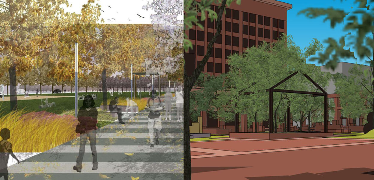
Citygarden– It is a vital asset to the master plan that was published alongside the completion of Citygarden. Glancing through the structuring elements from small structures, to sculptures and water features, to sustainable plants, it becomes clear that Nelson Byrd Woltz’s 2007 landscape design (above) is the essential document for St. Louis City and Gateway Foundation’s ambitious master plan. Thirteen years later, this wonderful urban park stands as a bold first step toward those ambitions. Citygarden’s exemplary hallway feature feels both its own space and an integral part of the park. Within the garden, thoughtful and dynamic elevations, plants, and building materials frame playful and energetic sculptures. It is my personal favorite place downtown, and its continued success speaks to the potential of the mall as a respite for citizens as well as a destination for visitors.

Redesigned Kiener Plaza– While Kiener has been redesigned (bearing no resemblance to the plan above) the results are less inspiring. In addition to not improving upon many of the structuring elements (there’s less water, less sculpture, fewer structures), it’s also not much to look at. The sunken May Amphitheater of the old Kiener gave it vertical character the new one lacks almost entirely. And while the new design seems to aspire to a flexibly programmable free-form space, it somehow achieves less programmability by its sheer ambiguity. In fact, the more likely justification for the redesign of Kiener can instead be found in the plan’s key themes. “The sunken design of the May Amphitheater, however, disconnects it from its surroundings. Because it is difficult to see into the plaza it is difficult to observe and police.” Thus Kiener eschews the plan’s structuring elements in favor of a “defensive design.” The result is predictably, even intentionally, less inviting.
Additionally, the vast expanse of bland gray digital-chic impermeable surface has the effect of destroying delineation of its boundaries, and creating a kind of vertigo as the color contrast of the checkered surface feels like a warped mirror image of the surrounding building facades. With its large grassy mound and smaller circuitous tree edging, it’s easy to see how it attempts to be a visual segue between the planned arching grass lawns of the coming CityArchRiver project, and the more private spaces of Citygarden.
In the end it’s ugly but serviceable. The new visitor’s center which opened this year is a welcome addition, and its design smartly mimics the parking garage directly to the north. While the open spaces seem daunting, there is a deceptively large amount of forested area, which improves with every growth season. The new Kiener does have its own less impressive section of hallway which trades consistency with the hall portion of Citygarden to create parking along its southern edge(against the suggestion of the plan.) Part of the hallway disconnect here is its separation from Citygarden by means of…
Peabody Plaza– While the newly redesigned Kiener is just a few years old, and will have to be tolerated for some time longer, Peabody plaza, now nearly 40 years old, needs to be reconsidered. The master plan takes Peabody as an inconvenient fact whereas I would like to just say– it’s time. Let us list its crimes: It denies views of both the mall and the Arch. It blocks views from the mall of perhaps the most architecturally significant building in St. Louis, the Wainwright Building. Its plaza on the southern half of the block, while having vertical character and some consistency with Citygarden, nonetheless impedes the flow of the hall to either side of it. It accomplishes none of the structuring elements of the master plan, and instead impedes them and the success of the mall with its very existence, which is itself the legacy of a complicated mess of compromises.
I do think some structure could be appropriate here, both to delineate the space between Citygarden and Kiener, and to provide more vertical character but it should be no more than two stories, it should seek to be a hybrid indoor/outdoor space, and to complement Wainwright and its surrounding blocks. As the value of the building continues to diminish, it becomes a more feasible investment on the part of the city and other interested parties to acquire it, tear it down, hold a parade to celebrate, and reimagine this entire block.
Serra Sculpture Park- The one remaining spot east of the Civil Courts building remains untouched since the 2009 master plan, and largely untouched since the sculpture’s, Richard Serra’s Twain, installation in 1981. A central walk path in Citygarden terminates at the sidewalk across the street and seems to suggest a direct line toward the sculpture which intentionally mimics the mast of a boat. The suggestion seems to be to choose the north or south route going west. However, most people simply avoid engaging with Twain altogether and stay on the sidewalk.
While the sculpture may seem to have a prohibiting look, that’s not Serra’s intention, whose more formal and forested design for the surrounding park would have helped create playful context, but has largely been ignored. Short of actually fulfilling Serra’s vision, more intentional paths leading from Citygarden’s central walk path would help animate this sculptural work, and the block itself –hopefully making it both a destination and meaningful forking path instead of denying it both.
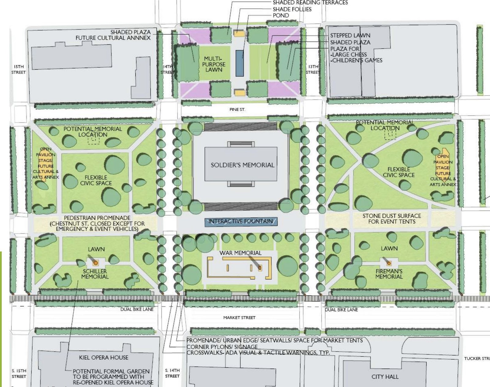
The Civic Room –That is– Soldiers Memorial and the 5 blocks of park space that ring it, remain mostly unchanged outside of the improvements that came with the renovation/restoration of the Soldiers Memorial, completed in 2020. New sidewalks now ring the memorial campus and this extends to sidewalks opposite the memorial to the east and west that feature large curbs for protected parking and street diets. The curb design here further solidifies available parking on the southern edge of the mall, and is likely the death knell for the idea of a bike lane on Market. This may be for the best, however, so long as bike traffic amenities continue to be improved on Chestnut, where a curb to separate the bike lane from one-way traffic is still needed.
The master plan calls for a different layout for the walk paths on each block that would be roughly symmetrical east to west. These imagined walk paths suggest places for small pavilions and new sculptural memorials, which seems like a timely opportunity to suggest more recent or culturally inclusive St. Louis heroes. The block between the memorial and Central Library contains more planned intentional features like a terraced lawn and a small pond. I welcome all of these changes so long as most of the beautiful mature trees in this room can be spared. Additionally, the relative lack of structures (both existing and planned) in the Civic Room as well as proximity to the memorial make this an ideal and appropriate spot to focus on ornamental gardens as suggested in the structuring elements.
Walkability
While we’re mentioning street diets, perhaps this is the best time to talk about walkability. Once upon a time, some of those major downtown streets like Market, Olive, and Tucker that flank and divide the mall weren’t so desperately wide. In the 20s and 30s the city actually widened them, destroying, and pushing back the facades of numerous buildings in the process. These extra-wide streets now create both a challenge and an opportunity. Here in the Civic room where the mall crosses Tucker and extends to Olive, this becomes most apparent. Tucker Blvd remains a daunting challenge if pedestrians and bikes want to continue east or west from either side along the mall. Market and Olive present similar challenges, say for someone coming south to the mall from Washington Ave, or fans approaching northward from Enterprise Center.
But, 100 years later, after highway systems have made these vast “stroads” obsolete, this widening also creates opportunities for amenities like bike lanes, parking, and much needed tree canopy along these routes, and these amenities needn’t compete with the current mall footprint, because all these streets (Tucker, Olive, Market) could and should be narrowed to make traversing them safer for our theoretical visitor, and for residents and employees of downtown.
“Street People”
And perhaps it’s most appropriate to intentionally discuss the downtown homeless population here, as this particular area is currently experiencing more problems related to homelessness. The plan, unfortunately, refers to them as “street people.” –
“Street people congregate in and around the Mall, especially in warmer months, partly because many services for this population are located nearby. Some people feel uncomfortable using the space because of the lack of activity and adequate lighting needed to create a safe atmosphere. No park design can solve the social issues surrounding street people; a broader solution is necessary. However, as has been proven in cities across the country, activities that attract a more diverse cross-section of users will contribute to the perception of safety and, in turn, attract more use.”
While this could be better stated, it’s not incorrect. The services referred to in the area include the Justice Center, The St. Patrick’s Center, Centenary Church, and the St. Louis Public Library (as well as the former New Life Evangelistic Center when the plan was published). This confluence of services and disservices make the Civic Room a place to be for people who don’t have another place to go. But creating more uninviting and defensive spaces is of course not the answer.
The continued failure of the city and region to meet this problem results in both difficult outcomes for the homeless themselves and somewhat appropriately, difficulties for a city attempting to raise its profile with both tourists and employers. As renovation and development is currently creating exceptional amounts of real estate in and near downtown, and ARPA funds expand the possibilities for permanent supportive housing, the City has an opportunity to use this momentum to give the homeless population a better place to be. Until then, perhaps here, in Poelker Park which faces City Hall, that population should remain most visible.

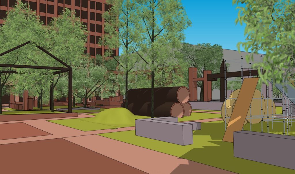
Neighborhood Room- This room gets its identity from its proximity to residential apartment buildings near it, most notably, the City View apartment complex to the north. Currently the renovation of the Butler Brothers Building to the northwest further anticipates this use. The plan calls for a dog run/park, play areas for children, small viewing mounds, and multi-use sports fields. Toward creating one contiguous park from 15th to 18th street it suggests closing/eliminating 17th street.
Losing 17th street across the mall is a no-brainer as it is currently confusingly aligned with Market and necessitates a traffic light. The only other thing this light serves is a small parking lot with about 20 spots, ironically next to a building with a large parking garage with access from 16th.
The other suggestions here seem appropriate for the space–playground, mounds, dog park, splash pads. The suggestion of sports amenities is a bit more difficult in this tight urban context unless a more intentional barrier could ring the space. The suggestion of softball in the space, outside of a batting cage, is laughable. Basketball, however, which could fit in this space, is most likely intentionally left out, and purposefully unannotated to avoid the inevitable basketball-court-debate.
It is also worth noting the neighborhood room’s utility to visitors of Union Station and the St. Louis Aquarium just to the west. The Aquarium, and the St. Louis Wheel tend to draw a lot of young visitors which would likewise be served well by a playground. Drawing visitors both young and old eastward from here (especially considering the new stadium and its parking just to the north) should be a priority.
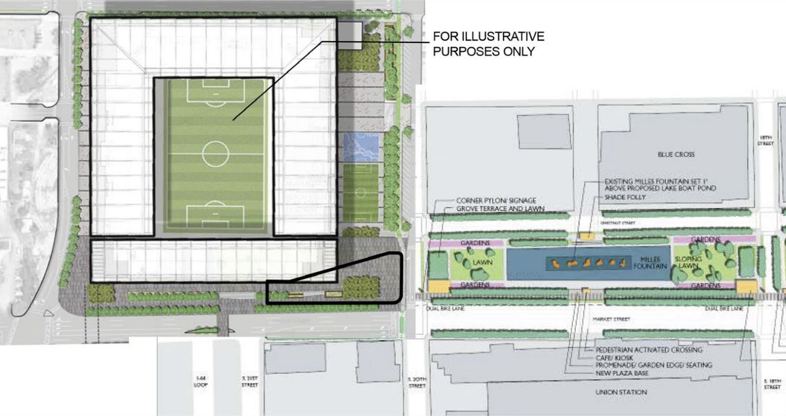
The Terminus – this room consists of Aloe Plaza–a two block plaza with a sculptural fountain, Meeting of the Waters, (originally titled the more descriptive Wedding of the Rivers, which was apparently too naughty for St. Louisans in the 30s?) on a raised terrace across from Union Station and what would have been another block of park west of 20th street that might have featured a large mound meant as the endpoint of the mall and a site for views back eastward.
As mentioned, the interests of the stadium resulted in an approved legal amendment to this part of the Master Plan in January of 2020. Now, the small section west of 20th is part of the plaza being built on the east and south sides of Centene Stadium. To the south, the stadium plan continues the hall design west to the edge of the Stadium campus at 22nd street. Along the eastern edge of the stadium a plaza/terrace extends 3 blocks north to south from Olive to Market and nearly a block east to west from 20th to 21st. Recently installed sculpture along this portion of the hallway references the history of Mill Creek Valley, a mostly Black historic St. Louis neighborhood, cleared for urban renewal, which included the footprint of the new stadium. This location is also the planned connection of the mall to GRG’s emerging Brickline Greenway. The Terminus plan suggests few other changes except some formalized gardens around the fountain, and a few shade pavilions.
While a large earthwork would have been an iconic addition, the new MLS stadium is bringing some much needed development attention to Downtown West. Additionally, the stadium itself seems well designed to the site, particularly where its roomy plaza connects to the mall. However, it’s still unclear from any of the plans I’ve seen just how the plaza’s Brickline bike path crosses 20th to continue along the mall. Pavilions, gardens, and perhaps more trees would be welcome additions to Aloe Plaza where its empty spaces lack the personality to frame the otherwise interesting excesses of the fountain.
A Keystone Plan
While major plans for the growing mall emerged throughout the 20th century as it grew eastward from Union Station, each with its own apparent unifying aesthetic, the mall we have today, in its 20-block totality is an eclectic mix of classical European architecture as well as modern, premodern, and postmodern American styles. It is instead a history of the entirety of the period in which it was conceived and built up to this moment.
As such, the 2009 plan understands itself less as a stylistic force for the mall but appropriately as a keystone that connects and finishes this emergent work. Today, the mall’s eclectic nature is very much still best served by the hall-and-rooms format of the 2009 plan. The hall promenade, meant to run along the south edge of the mall as a unifying portal to the many and disparate spaces and styles it connects, is the plan’s pivotal and most attainable goal. Each new space that is redesigned without direct reference to and alignment with Citygarden’s hall feature is a missed opportunity both to formally frame the emergent maximalism of the spaces, and to create a singular well defined feature to draw visitors into the mall and from one end to the other.
Interestingly, with its march eastward toward the river, that emergent effort left two buildings standing in its path–The Civil Courts building built in the 1920s and the Old Courthouse originally built in the 1840s. With the creation of the mall’s new terminus at Centene Stadium in the 2020s, the mall stretches westward neatly embodying a twenty decade timeline of expansion over 20 city blocks, one interrupted by three buildings each built a century apart–An embodiment of westward expansion the Gateway Arch merely signifies, sculpted in halting eastward strokes in the direction of Twain’s arrowhead.
At least, that would be the case were it not for Peabody Plaza. While the 2009 plan attempts to finish the work of the Gateway mall it accepts the mistake of Gateway One/Peabody as inalterable. Thirteen years later, after the amendment to the Terminus plan it is time to consider amending the plan again to reimagine the block between 7th and 8th Street.
Reimagining Peabody Plaza

The following designs were created in the spirit of adding views of the Gateway Arch and the Wainwright building, observing historic and civic identity, re-establishing the auditorium space lost with the redesign of Keiner, as well as respecting the hall-and-rooms structure and observing the structuring elements of the 2009 plan. Note: Peabody Plaza currently has a handful of tenants. I’m not advocating sweeping them out the door and knocking over their building tomorrow. These things take time. Even if they enjoy their space at Peabody, I hope they can agree it is a matter of civic importance to reimagine this space.
A Civic Park

The first, a civic park, takes inspiration from the Flag of St. Louis and from the confluence of rivers that in turn inspired it. From the two crosswalk entrances across 7th street, cascading fountains that take advantage of the natural slope of the block provide seating on either side and frame a stepped down auditorium space that faces a central stage pavilion. At the stage the two fountains merge into a curving stream that winds eastward toward an entrance at 8th street across from Citygarden’s central path.


Around this central feature, a winding path cuts through a second arched entrance off the hallway and allows for playful traversing of the park’s greenspace at the east end. Other, more informal spaces on the north and south ends provide tree canopy and additional seating facing the stage, and anticipate sculpture and programming.


An Industrial Monument


The second is a pyramidal monument with an interior museum space. Steps on the east and west sides provide access to a top platform for views just above the tree canopy where a central pedestal fountain would be noticeable from Kiener and points west. Similar fountains descend the structure and delineate space on the northern side for a large auditorium area and open stage, and an accessible ramp on the southern side off the tree-lined hallway plaza.


Situated centrally between the Old Courthouse and the Civil Courts, the fountains which could be cool in summer months and heated in winter to produce dynamic steaming “stacks” are meant to evoke the century of industrial history that occurred between the construction of those court buildings. A gallery space on the interior could interpret that history, and the block could potentially retain underground parking for the museum.


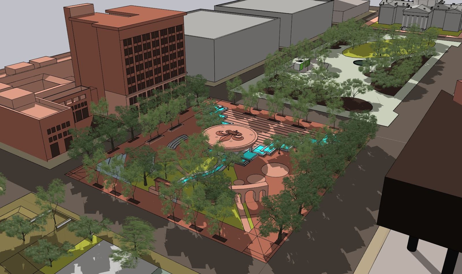
A Historical Ruin
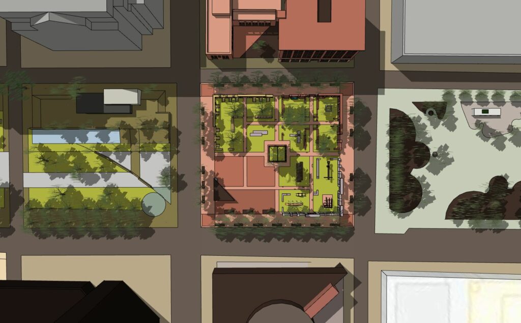
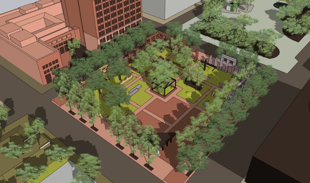
This third and final design, a built ruin, makes reference to the history of this block that was demolished to create the “half-mall”. Three ruined facades ringing three-quarters of the block and a smaller portico under a stage pavilion on the southwest corner evoke the four buildings which stood on this spot before demolition in the early 1980s.
At the southeast corner a ruined two-story base facade of the Buder Building frames the edges of a construction themed play area.

At the northeast corner a facade of the Lincoln Trust Building, adjacent to its contemporary Wainwright Building, frames a series of four tree-covered gardens in its H-shaped footprint, intended to create a more relaxed atmosphere.
At the northwest corner, in the L-shaped footprint of the Liggett Building, tree canopy shades stone outdoor dining tables along the facade’s street facing window openings.

At the southwest corner a stage pavilion hoisted up by a columnar ruin and steel I-beams faces an open programmable plaza space.


At the center a surreal steel outline of a house containing trees evokes even older histories of the site and visually continues the theme of the play area.
Original building art from some of these buildings, saved by the late preservationist Larry Giles and now housed in the collections of the National Building Arts Center, could possibly be reintroduced to the site among these built facades.
An Inter-generational Exquisite Corpse
The exquisite corpse of St. Louis history that is the Gateway Mall is closer to being a complete project than perhaps it ever had any right to be. That halting progress speaks to the fact that the mall is not one generation’s ambition, but somewhere in the perennial spirit of the city itself. Too much has been sacrificed in its name for it to now stand flawed or incomplete. The 2009 Gateway Mall Master Plan and its once (and future?) amendments are well equipped to see it through to that (at least for now) completion.
